Incorporated on October 15, 2003, the City of Maricopa has a rich history of agriculture and transportation. However, agriculture is currently giving way to rapid suburban expansion from the Phoenix metropolitan area as the Maricopa area transitions from a rural city to a suburban and urban community. The economy of the City, traditionally an agricultural center, is diversifying and currently heavily influenced by the residential and retail construction and real estate industries.
This General Plan provides the City with the blueprint for an enhanced economy, orderly growth and support of Maricopa's neighborhoods and desired community character. The Plan is intended to implement, and where necessary expand on the planning goals and strategies of the citizen-driven 2040 Vision Strategic Plan (adopted May 5, 2015). The Introduction Section contains guidance for using the General Plan document, identifies the basic assumptions for organizing Maricopa's planning principles, and provides direction for administering the plan.
Local History
 Maricopa has a long and rich history that dates back over 300 years. The first known historical reference to Maricopa is a 1694 journal entry by Father Eusebio Francisco Kino, describing an area that would become Maricopa Wells. He noted an established agricultural community populated by friendly Native Americans who were established traders.
During the Mid-1800s, while still part of Mexico, Maricopa Wells was a dependable source of water along the Gila Trail. It became an important and famous stage stop, offering food, water and care for travelers' animals, along the Butterfield Stage Line that stretched from San Antonio to San Diego.
The 1870s brought the railroad south of the wells. Phoenix was little more than a tiny village on the Salt River but growing political influence led to the building of a spur line from Maricopa to Phoenix. Maricopa became an important junction for two railroads, the Southern Pacific Railroad and the Maricopa & Phoenix Railroad (M&P), in July of 1887. Daily, hundreds of people could be seen waiting at the Maricopa Railroad Station, or one of the two hotels that paralleled the tracks, to board east-west trains or those heading for Tempe and Phoenix. Unfortunately, the M&P suffered difficulties from the beginning. Floods frequently washed out the line causing the trains to be a day to a week late. Eventually, a new railroad line was built from Picacho through Coolidge, Chandler, Mesa, Tempe and into Phoenix. Southern Pacific closed the M&P completely in 1935, and tore up the tracks that ran from Maricopa to Phoenix a few years later. Today's Maricopa Road (also known as State Route 347 and the John Wayne Parkway) lies over the top of the old rail bed.
Maricopa settled into a slower pace as rail traffic north was halted in 1935. Agricultural production had been consistent through time in Maricopa, creating a healthy farm economy. Maricopa has been one of the most productive farm communities in the state. Cotton, grains, fruit, vegetables, and beef thrive in this arid desert. Cotton was king during the 1950-60s. The streets were alive with cotton pickers from the Midwest and Mexico. In the 1970-80s hundreds of acres of farmland were sold to developers who subdivided it into 3 1/3 acre mini-farms which attracted large numbers of residents from all walks of life and occupations, bringing with them a dream for a better life and a desire to raise their children in the country.
Since the incorporation (October 2003), the City of Maricopa has become one of Arizona's fastest growing communities transforming from an agricultural community of under 2000 to a city of over 46,000 as of 2015. Most residents are employed in non-farming industries and commute to their places of employment in nearby Casa Grande or the greater Phoenix area. Maricopa has experienced a significant increase in home occupations, accounting for 60% of all businesses in the City as of 2015, and is also becoming a regional hotbed for the agritech industry as well as a “clean and green” industry hub. The City is home to a thriving cluster of local agritech businesses and research facilities, including the USDA Arid-Land Agricultural Research Center and the University of Arizona Maricopa Agricultural Center. On the renewable energy side, Pinal Energy opened the state's first ethanol plant in Maricopa in 2007 and Waste Management and Garick have partnered on a green waste to fuel project.
The City continues to grow steadily as noted by construction activity that has averaged 33 new residential homes every month over the past 3 years. Based on proximity to the Phoenix metropolitan area and the inevitable depletion of available land in the East Valley, Maricopa will likely continue to experience exponential growth.
Overview
The Maricopa General Plan is a general, long-range, comprehensive expression of the future vision of the City. The Plan implements the citizen-driven 2040 Vision Strategic Plan by providing specific focus on the vision goals and strategies and further detailing 15 year goals, objectives, and direction to guide public and private decisions related to growth and development of Maricopa and in the Maricopa Planning Area. The General Plan provides guidance to citizens regarding the physical development of the community, while giving property owners and developers a clear indication of policy directions affecting physical development. The Plan is a guide to City management, City departments, the Planning and Zoning Commission and City Council with specific regard to the City's future development proposals, Capital Improvement Program, the Council's Strategic Plan, and the annual City Budget.
The City of Maricopa General Plan is divided into three sections:
- Section I: Introduction contains guidance for using the General Plan document, identifies the basic assumptions for organizing Maricopa's planning principles, and provides direction for administering the plan.
- Section II: General Plan Elements are the subject matter components that provide a logical, comprehensive structure for planning the City. In Arizona, growing municipalities of over 50,000 in population are required to address a number of elements pertinent to sustainable growth and development of Cities and Towns.
- Section III: General Plan Implementation identifies the actions necessary to ensure that the policies and objectives of the Maricopa General Plan are carried out effectively. It highlights policy coordination with the City's 2040 Vision Strategic Plan, specific General Plan monitoring actions, and provides guidelines for land use decision-making.
The General Plan is intended to provide a framework for all of the interrelated functions of the City of Maricopa. The goals and policies in the General Plan are implemented through ordinances, regulations, ongoing procedures, recommendations from City boards, committees and commissions, and decisions made by the City Council. The General Plan is also carried out by private actions and initiatives in the community. Whether public or private, implementation of the General Plan takes many forms. Some of the most recognizable applications of the General Plan include the City's physical development, road expansions and roadway/transit planning, neighborhood revitalization projects, capital improvements, fiscal planning, budgeting and project funding, and recreation facilities.
The framework for the General Plan is regulated by the State of Arizona, which requires the General Plan to establish community-wide goals and development policies for a variety of topics. Every ten (10) years, the City is required to update its General Plan and send it to the Maricopa voters for ratification. The City is also required to render an annual report on the status of the General Plan and progress in its application.
Arizona State Statues require consistency between the adopted General Plan and all zoning regulations and rezoning actions. Applicants for such requests should refer to the whole document, as well as any adopted Functional (Master) Plan (Transportation Master Plan, etc) or Specific Area Plan, such as the Redevelopment Area Plan.
The General Plan is:
- an expression of the preferences of residents and property owners
- a statement of City policy designed to achieve the citizen's vision
- a framework for future plans and decision making
- a means of enhancing the quality of life of the citizens
- a legal requirement under Arizona State Law
The General Plan is not:
- a tool to promote special interests
- a rigid, unchanging or inflexible document
- a detailed policy or ordinance for specific properties or areas
- a Capital Improvement Plan
- a zoning map
What's New?
Planning Maricopa, which is the new title of the General Plan, updates the City of Maricopa General Plan 2006 to include new state requirements and reflect community, regional, and national changes that have occurred since the original plan was created. The following are some aspects of Planning Maricopa that are different from the 2006 General Plan:
- Nine new elements to comply with statutes for a population exceeding 50,000:
- Growth Element
- Housing Element
- Rehabilitation & Redevelopment Element
- Neighborhood Preservation & Revitalization Element
- Environmental Planning & Resource Conservation Element
- Water Resources Element
- Energy Element
- Safety Element
- Public Buildings (Facilities and Services) Element
- New vision statement and a logical reorganization of the General Plan Elements
- Focus on redevelopment, revitalization, and infill development to leverage existing public facilities and services to maximize existing resources.
- Significantly reduced population projections and growth rate
- New Growth Area + Employment Map
- Land Use Pattern for concentrated Village Centers serving groups of surrounding neighborhoods
- Emphasis on a multi-modal transportation system and relationship to land use decisions, public health, and an integrated economy.
- Updated Land Use Map incorporating Village Center areas and new Employment designations along planned transportation corridors in the Planning Area
- Updated Special Planning Area discussion
- Emphasis on open space connectivity
- Public Art (and Culture)Section
- Human Services initiatives
- Public communications initiatives
- Smart Cities Initiatives
- New Public Buildings Map
- Expanded Level of Services discussion
- Definition of General Plan Text Amendment criteria
- Expanded tools for carrying out the General Plan Implementation and annual progress reporting
What's NOT New?
- The broad concepts of the 2006 General Plan are still applicable
- Healthy single family housing lot inventory into 2030, need for housing diversity
- Redevelopment of the Heritage District as a vibrant mixed use activity center
- Regional transportation goals and coordination
- Balance between housing and jobs
- Need for increasing the retail sector and available commercial space
- Major and Minor General Plan Amendment criteria
Introduction - Section I
The Introduction Section explains the history, culture, and context of Maricopa from its origins as a supply stop for covered wagons and the railroad, through the City's incorporation in 2005. The Section outlines and explains the following topics and administrative functions:
- Preface
- How to Use the Plan
- Maricopa's Vision for the Future
- General Plan Purpose
- Planning Assumptions & Principles
- Plan Administration
- Statutory Plan Requirements
Vision Statement
The City of Maricopa is a family friendly, vibrant community that offers diverse opportunities in culture, technology, education, business, entrepreneurship, transportation, entertainment, and recreation for all ages. A close-knit community of committed leaders, engaged citizens, and diverse partners with pride in our history, and a shared vision for a prosperous future.
- 2040 Vision Strategic Plan(PDF, 2MB)
General Plan Elements - Section II
A. Growth Area Element
One of the primary functions of planning is to understand and accommodate various types of land use activities to achieve a sustainable balance of uses while enhancing assets and preserving resources. Land use activities need to be properly situated to ensure the health, safety, adequate public facilities, aesthetics, protection of property values and overall quality of life in the community. The purpose of this element is to link land use, transportation, facilities, and infrastructure with specific implementation tools such as zoning ordinances, strategic plans, the capital improvement program, etc. Sustainability is a core principle of Maricopa's growth management strategy to guide community growth in a manner that will enhance the lives of residents for generations to come.
The Growth Area Element organizes the City's growth strategy in the following segments:
- Commercial & Employment Growth
- Residential Growth
- Annexations
B. Land Use Element
The purpose of the Land Use Element is to guide development and re-development in an orderly manner and balance growth with preservation of the community's assets. The General Plan designates the location and extent of private (residential, commercial, industrial) and public (education, recreation, open space) land together with the density and intensity for land use categories. The aim is to foster growth in the Maricopa economy with thriving neighborhoods that are integrated with, and highly accessible to, good jobs, shopping, amenities and recreation.
The Land Use Element organizes the City's desired future land uses in the following sub-topics:
- Development Pattern
- Village Planning & Village Center Development Pattern
- Mixture of Uses
- Other Land Uses
- Land Use Plan
- Housing Element
- Redevelopment & Revitalization
- Heritage District Redevelopment Area
- Seven Ranches Area
- Saddleback Estates
- Special Planning Areas
- Estrella Gin Site
- Copper Sky Mixed Use
- City Center
- Arizona State Land Development
- Neighborhood Preservation & Revitalization
C. Environmental Planning & Resource Conservation Element
The Environmental Planning & Resource Conservation element of the General Plan describes City of Maricopa's efforts in the area of environmental sustainability and provides a framework for development that conserves resources to protect Maricopa's future. This element addresses protection of air and water quality, land resources, and promoting healthy communities. The policies and strategies in this element are largely broad-based with community-wide applicability. The discussion and strategies are also intended to complement and support those identified in other sections.
- Air Quality
- Floodways & Washes
- Energy Element
- Water Resource Element
- Water Supply, and;
- Waste Water
D. Safety Element
Maricopa's residents take comfort knowing they live in a safe community and where citizen involvement supports and upholds the value of safety and security in Maricopa. Maintaining a community in which all residents, businesses and visitors are safe requires the efficient and effective use of public safety resources and active citizen involvement in promoting safety and security in their own neighborhoods and community.
The Safety Element, in conjunction with the goals and policies of the Emergency Services section provide a framework to address the protection of the community from any risks associated with naturally occurring, human induced or national emergencies that could affect the City. Whether extreme climate, flooding, national disasters or even the handling and transportation of industrial chemicals, the City must be prepared to manage these risks through awareness and preparedness by way of adequate planning, staffing, training and infrastructure. There are two primary areas of real and perceived safety this element addresses: neighborhood safety and hazard mitigation and emergency preparedness. This element establishes the framework to ensure the City's ability to prevent or respond to threats to the community.
E. Circulation & Connectivity Element
Maricopa strives for an integrated, citywide, regional, and multi-modal transportation system that is safe, functional and integrated with smart city practices. The Circulation & Connectivity Element is intended to guide the development of a citywide multi-modal transportation system integrated with, and in support of the land use element. Over the next 20 years, travel in the Maricopa planning area will dramatically increase proportionately with anticipated population growth in the region. In support of sustainable growth and economic development, the City's circulation system will need to keep pace.
The Circulation and Connectivity Element serves as the City's General Plan transportation element and consists of the following sub-elements:
- Introduction
- Regional Connections & Roadways
- Pedestrian & Bicycle Circulation
- Transit
- Circulation Plan
F. Economic Development Element
The Economic Development Element provides guidance and direction for planning to establish a fully integrated municipal economy providing opportunity for residents to live, work and play. The citizens of Maricopa envision an economically prosperous, dynamic and sustainable community. One that offers a government structure that is welcoming and supportive of business and employment growth. Since incorporation, this vision has been one of the City's initial goals in an effort to ensure Maricopa is more than yet another bedroom community in Arizona. Jobs, revenue and financial stability contribute to a municipality's economic health. The Economic Development Element seeks to promote these attributes by planning for increased household incomes, improving the community's jobs-to- housing balance, and by attracting expanded retail, commercial and industrial business within the City of Maricopa's target sectors, as updated from time to time in the Strategic Plan for Economic Development.
This element provides the framework for establishing an integrated local economy and consists of the following sub-elements:
- Introduction
- Assets and Advantages
- Economic Challenges
- Employment Centers & Corridors
G. Parks, Recreation and Open Space Element
The Parks, Recreation and Open Space Element has been prepared to support the establishment of standards and levels of service criteria that lead to the creation of a full-service parks, recreation and open space system in Maricopa. Citizen preferences place high priority on developing and having adequate access to parks, recreation, leisure activities, community and cultural events and performing arts to serve the diverse community. The City has been playing ‘catch-up' in meeting the needs for large scale open spaces and regional recreation amenities. This Element identifies a comprehensive network of park, open space, trails, and recreational amenities according to the needs and standards for Maricopa.
- Introduction
- Community Services Department
- Achievements from Previous Planning Efforts
- Role of Private Development
- Parks, Recreation, Open Space and Trails Inventory
- Needs Analysis and Standards
- Open Space Plan
- General Open Space
- Public Health and Recreational Activity Opportunities
- Parks & Trails
- Neighborhood & HOA Parks
- Community, Village and Grand Parks
- Special Use Parks
- Paths and Trails – Paved and Unpaved
- Bicycle & Pedestrian Network
- Public Art
H. Public Buildings, Facilities and Services Element
Ensuring adequate public facilities and services demonstrate the City's commitment to orderly growth. Certain services, like water and wastewater utilities, are privately provided in Maricopa, highlighting the need for cooperative efforts in maintaining acceptable levels of service at reasonable costs. The availability of public services and facilities will enable Maricopa to meet its future population expectations, accelerate growth in desired areas of the community, and, if needed, the flexibility to constrain development where growth is not desired. Developer provided infrastructure, coordinated with the City's efforts (including Smart Cities Initiatives), is an important component of this Element.
- Public Buildings
- Public Services and Facilities
- Emergency Services
- Courts
- Community Services
- Human Services
- Solid Waste Collection and Disposal
- Flood Control
- Education Facilities
- Information Technology
- Communications
- Utility Services
- Water Services
- Wastewater Service
- Electric Service
- Natural Gas & Biofuels
- Telephone and High Speed Data
- Functional Plans
- Cost of Development Element
General Plan Implementation - Section III
The Implementation section identifies the actions necessary to ensure that the policies and objectives of the Maricopa General Plan are carried out effectively. The intent of this section is to explain the tools to implement the General Plan and to organize the listing of near-term implementation activities derived from the Goals, Objectives, and Policies within each Element and prioritize them for timely completion.
To ensure ongoing implementation of the Maricopa General Plan as an important, practical, up-to date, and consistent statement of City policy, the following implementation tools are utilized:
- The City Council Strategic Plan is reviewed and updated annually to include action-oriented policies to guide daily decision-making.
- Plan Monitoring for measuring performance and annual maintenance updates.
- Land Use & Development Decision Criteria to assist in evaluating proposed development projects and assure their consistency with General Plan principles.
- Implementation Work Program to organize the near-term implementation activities derived from the Goals, Objectives, and Policies within each element.
The Maricopa General Plan, the City's first update to the inaugural General Plan, represents a statement of what the public expects their City to become. It is driven by citizen input captured in the 2040 Vision Strategic Planning process, conforming to the letter and spirit of “Growing Smarter Plus” legislation established by the State of Arizona to guide municipal planning and growth management. The General Plan elements and compliance with statutory requirements are further explained in Subsection G.
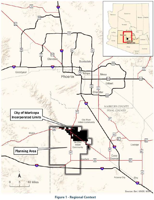
Planning Area expands the geographic base of Maricopa's influence well beyond the present City limits. Coordination with Pinal County, State and Federal governments and private landowners is a fundamental premise of the compatible, thoughtful development desired to provide for orderly growth and adequate provision of essential infrastructure and services. The Maricopa Planning Area includes approximately 233 square miles of western Pinal County ranging from the Gila River Indian Community on the north, the City of Casa Grande Planning Area on the east, Interstate 8 to the south and the Pinal/Maricopa county line on the west. Through wise use of municipal resources, the City hopes to exert a positive influence on growth and development issues under Pinal County's jurisdiction. A strong, cooperative relationship between the City and the County is crucial in implementing necessary growth management practices while facilitating healthy economic growth in western Pinal County.
The Maricopa General Plan is a general, long-range, comprehensive expression of the future vision of the City. The Plan implements the citizen-driven 2040 Vision Strategic Plan by providing specific focus on the vision goals and strategies and further detailing 15 year goals, objectives and direction to guide public and private decisions related to growth and development of the City of Maricopa and in the Maricopa Planning Area. The General Plan provides guidance to citizens regarding the physical development of the community, while giving property owners and developers a clear indication of policy directions affecting physical development. The Plan is a guide to City management, City departments, the Planning and Zoning Commission and City Council with specific regard to the City's future development proposals, Capital Improvement Program, the Council's Strategic Plan, and the annual City budget.
The City of Maricopa General Plan is divided into three sections, these are:
- Section I: Introduction
- Section II: General Plan Elements
- Section III: General Plan Implementation highlights policy coordination with the City's 2040 Vision Strategic Plan, specific General Plan monitoring actions, and provides guidelines for land use decision-making.
The General Plan is intended to provide a framework for all of the interrelated functions of the City of Maricopa. To define the General Plan we can say:
The General Plan is:
- an expression of the preferences of residents and property owners
- a statement of City policy designed to achieve the citizen's vision
- a framework for future decision making
- a means of enhancing the quality of life of the citizens
- a legal requirement under Arizona State Law
The General Plan is not:
- a tool to promote special interests
- a rigid, unchanging or inflexible document
- a detailed policy or ordinance for specific properties or areas
- a Capital Improvement Plan
- a zoning map
The Maricopa General Plan is intended as a guide. It summarizes the purpose of the Plan, goals and objectives to achieve the vision for future Maricopa and the required General Plan Elements for a community over 50,000 in population. All Elements are interrelated and intended to be considered collectively in public and private decision-making. Users are strongly urged not to rely on select, excerpted statements; but, rather, are encouraged to consider all the subject matter of the Maricopa General Plan as a whole.
Maricopa welcomes users of the Maricopa General Plan, and our City staff stands ready to assist in any way possible. Inquiries regarding the General Plan should be made to the City of Maricopa, 39700 W. Civic Center Plaza, Maricopa, Arizona 85138, phone (520) 568-9098.
Citizens of Maricopa have awareness that their community is growing very quickly, public services and facilities are working to keep up, commercial retail and employment related development is lagging behind the development of new neighborhoods. Understanding growth is a regional reality; the public wants to be sure that the future Maricopa is better, not just bigger. Retaining small City attributes of friendliness, respect for community heritage, family-oriented, safe neighborhoods and traditional civic events are important to most residents. Planning vision comes from thoughtful, enthusiastic public participation. The following statement is from the City's 2040 Vision Strategic Plan using the concepts and words of citizens to define the broad mission that will benefit all.
Our Vision for the Year 2040
The City of Maricopa is a family friendly, vibrant community that offers diverse opportunities in culture, technology, education, business, entrepreneurship, transportation, entertainment, and recreation for all ages. A close knit community of committed leaders, engaged citizens, and diverse partners with pride in our history, and a shared vision for a prosperous future.
- 2040 Vision Strategic Plan(PDF, 2MB)
 The primary purpose of the Maricopa General Plan is to provide a tool for the community to guide and coordinate development efforts over the coming 15-year period.
Through the 2040 Vision Strategic Plan and the General Plan Evaluation and Assessment Public Review process, citizens of Maricopa assisted in the development of a plan that embraces their vision of an economically prosperous, family-oriented community with supporting services.
In its adopted form, this comprehensive planning document, Planning Maricopa, shall serve as a general guide for the City Council, the Planning and Zoning Commission, the various City Boards, Committees and Commissions, and City staff, as well as public and private interests regarding development and growth in and around the City of Maricopa.
The General Plan includes analyses of current conditions and direction for future land use decisions. There are a few fundamental understandings, planning assumptions, which assist in organizing Maricopa's General Plan principles. City development policies coincide with these basic directions.
Assumptions
- The 2040 Vision Strategic Plan was adopted May 5, 2015, and is designed to “…challenge and stretch the community's imagination and commitment to creating a “best, great and exciting,” rather than a “good enough” future.” The plan stands as a blueprint for positive change and progress derived through a community based definition of key issues and recommendations for the future. The plan also provides guidance for the development of other more specific plans focused on achieving more narrowly defined goals and objectives. A key aspect of the plan is the adoption of the “Smart City” initiative, which refers to the application of technology to create a more efficient and higher performing infrastructure that will effectively contribute to community well being, reduced costs, and resource conservation.
- The population of Maricopa's Municipal Planning Area is expected to increase steadily with a projected population of approximately 105,000 by the year 2030. Modeled on recent, local growth rates – the growth increment is a highly supportable assumption. Maricopa's projected population for the Planning Area at buildout is 633,880.
1Source: 2014 MAG Socioeconomic Data
- Agriculture and construction may not be sustainable as the principal economic activities of the community. Community energy is focused on construction, infrastructure development, and economic diversification as the area has transformed from farms and cattle operations to suburban development.
- Adopted plans – the Area Transportation Plan and Regional Connectivity Plan– are considered current and function in support of the General Plan. The Redevelopment Area Plan (Heritage District) and the Parks, Trails and Open Space Master Plan require updating to reflect accomplishments and changes that have occurred over time, and to support the goals and strategies of the 2040 Vision Strategic Plan. These adopted “Plans” serve to implement the General Plan, are meant to be consistent and provide supporting policy and direction.
- Traffic will increase on SR-347 along with safety and access concerns. As Maricopa continues to grow along with Pinal and Maricopa Counties, average daily traffic on John Wayne Parkway in Maricopa will dramatically increase. Developing as a “transit ready” community with multiple modes of transportation will serve the health and well-being of the community and afford more efficient use of land and resources.
- Neighborhoods and a strong sense of community are a foundation of the General Plan. Neighborhoods in Maricopa constitute the framework for practicing citizenship. General Plan strategies keep neighborhoods in mind. Neighborhood groups have roles in Plan monitoring and performance measurement. They are looked to for acceptable standards of security, convenience, appearance and amenity at the grassroots level.
- Economic development should emphasize job creation, business retention and expansion, and municipal revenue generation. The City plans to attract more jobs and businesses and assist local business growth. Providing available commercial retail, office and flexible light industrial space is critical to this effort. New firms that contribute higher-wage occupations are, also, specifically targeted.
- Development proposals are expected to coordinate with and participate in costs of infrastructure and services. A fair-share approach is preferred with new development expected to construct or fund the infrastructure, including major off-site participation, needed to support its residents.
- Revitalization within the Heritage District helps project Maricopa's positive image. Revitalization is an opportunity to capitalize on Maricopa's rich history through implementation of the Redevelopment Area Plan and the Heritage District Design Guidelines that make Maricopa unique. The Heritage District should be a point of pride for City residents.
- Annexation: As a thriving community, Maricopa understands that growth is inevitable. Maricopa pledges to work with all landowners to support annexations that facilitate logical expansion of our boundaries in order to advance quality development.
Based on these assumptions, principles were developed to guide planning policy toward Maricopa's desired vision.
Principles
Maricopa's comprehensive planning approach establishes basic principles that assist in translating Assumptions and Element Goals into progressive community action.
1There will be explosive population growth in the municipal planning area, an estimated 30% increase from 2015 estimates to 73,000 residents by the end of 2020, and approximately 138,000 in the planning area by 2040. The majority of the increment is projected to occur inside the current City limits. Nearly 27,000 dwelling units could be constructed to accommodate population growth through 2040. Job forecasts add employment of 32,946 over the next 25 years. Commercial and institutional development is projected to increase — more than 6 million square feet by 2030, with the greatest concentrations expected along John Wayne Highway, the Maricopa-Casa Grande Highway and SR 238.
-2014 MAG Socioeconomic Data
The purpose of this section is to provide administrative direction, criteria and procedures for compliance with State Statutes, including Growing Smarter/Plus legislation, and a template for local code consistency. Further direction is provided for the General Plan amendment process in the Maricopa Zoning Code.
1. General Plan Adoption
In accordance with Arizona Revised Statutes (9-461.06-K), the Maricopa General Plan is effective for up to ten years. The General Plan can be updated or readopted at any time at the discretion of the City; however it must be updated or readopted within ten years from the date of adoption. As conditions change, including demographic shifts or the emergence of new economic trends, the General Plan will require a comprehensive update.
The Maricopa General Plan is adopted by a two-thirds majority vote of the City Council and ultimately ratified by the voters of the City of Maricopa at a general or special election in accordance with Arizona statutory requirements. At a minimum of every ten years, a new General Plan or the currently effective General Plan shall be submitted for adoption or re-adoption. Major amendments to the General Plan must also be approved by a two-thirds majority vote of the City Council as further detailed in the following Major Amendment subsection.
The process of General Plan adoption entails four key steps. The Plan is provided to outside agencies abutting or within the Planning Area, including but not limited to Pinal County Community Development, Maricopa County, Indian Communities, City of Goodyear, City of Casa Grande, the Central Arizona Association of Governments, Maricopa Association of Governments, State Department of Water Resources, and the State Commerce Authority (or designated planning agency for the state) for a review period of at least 60 days. The Maricopa Planning and Zoning Commission reviews the General Plan at two or more public hearings at different locations within the City to promote citizen participation. Third, the Maricopa City Council also holds a public hearing for final public comment. Upon City Council approval, the General Plan is then ratified by the voters of the City of Maricopa. Also refer to Arizona Revised Statute requirements as they may change from time to time.
2. Relationship to Other Plans
Adopted interrelated plans are incorporated by reference into the General Plan and include such documents as the 2040 Vision Strategic Plan, Area Transportation Plan, Regional Connectivity Plan, Transportation Master Plan, Parks Trails and Open Space Master Plan, Redevelopment Area Plan, Development Impact Fee Study, Capital Improvement Plan (CIP), and other studies or plan updates adopted by the City Council from time to time.
The General Plan provides comprehensive direction across several Plan Elements. Existing and future, detailed functional “Plans” or “Master Plans” will serve to implement the General Plan, and are meant to be consistent and provide refinements for individual functions, disciplines or geographic areas of the Maricopa planning area.
All adopted Plans, codes and policies are intended to integrate with the General Plan. Where greater detail and direction is provided in these Plans, codes and policies, such directions shall prevail and will be followed.
3. General Plan Amendments
Frequent changes to the adopted General Plan are both ill-advised and, statutorily restricted. The General Plan was prepared with public input and analysis of existing conditions and community needs. Permitting multiple, uncoordinated alterations undermines the community's investment in the planning process and is counter-productive to achieving the long term, agreed upon vision for Maricopa.
There are two types of General Plan Amendment, Major and Minor. A Major Amendment is a revision to the Maricopa General Plan text or Land Use Map that has far-reaching consequences on the use of land areas, demand on available infrastructure and/or substantially alters or is inconsistent with specified residential density or development intensity. A Minor Amendment is any other revision to the General Plan map or text that does not meet the criteria for a Major Amendment as explained below.
Major General Plan Amendment
General Plan Major Amendments are governed by Arizona Statutes, ARS 9-461.06. The statutes allow Major Amendments to the General Plan once per year. The Planning and Zoning Commission shall hold two public hearings on the Major Amendment(s) and the City Council shall hold one. A two-thirds vote by the City Council is required to approve a Major Amendment. Furthermore, the statute defines a General Plan Major Amendment as a substantial alteration of the municipality's land use mixture or balance as established in the municipality's General Plan land use element.
Planning Statutes require municipalities to define the criteria to be used in determining if a proposed plan amendment effects a substantial alteration of the municipality's land use mixture or balance as established by the adopted General Plan.
Major Plan Amendments may be proposed to the Future Land Use Map and text of the General Plan.
a. Major Map Amendment
The determination, if a map amendment is a General Plan Major Map Amendment, are by two criteria. The criteria include land use and infrastructure.
Land Use Criteria
A Major Amendment to the Maricopa General Plan is any proposal that would result in a change of such significance as to impact substantial portions of the entire City and/or its Planning Area. Amendments are based upon the relative size, in land area, and extent of change proposed, in terms of development intensity (e.g. dwelling density), as well as its relationship with surrounding land uses and impact upon public infrastructure.
The following changes in land use designations within the city limits on the Future Land Use Plan require a Major Amendment to the City's General Plan:
Table 1 - Major Plan Amendment Land Use Criteria within City Limits
| Current Designation |
Proposed Designation |
Acres to Trigger a Major Amendment |
| Residential (Rural, LDR, MDR, HDR, MPC) |
Employment, Light Industrial, R&D |
160 |
| Residential (Rural, LDR, MDR, HDR, MPC) |
Commercial |
80 |
| Residential (Rural, LDR, MDR, MPC) |
More intense Residential Category (example: MDR to HDR) |
80 |
| Employment, Light Industrial, Research and Development |
Residential (LDR, MDR, HDR, MPC), Commercial |
40 |
| Mixed Use |
Any |
40 |
| Commercial |
Any Residential |
40 |
| Agriculture |
Residential (MDR, HDR, MPC) |
80 |
| Agriculture |
Commercial, Employment |
40 |
| Open Space |
Any |
20 |
Any Land Use
(other than noted above) |
Any Proposed Designation |
Total aggregate of 160 acres or more. |
| *Refer to Section II B1.d Land Use Plan for definition of terms. |
This table (Table 1) represents the land use criteria for determining a major amendment for areas inside the city limits and is separate from the infrastructure criteria. If the above thresholds are not exceeded, or the proposed area of change is generally consistent and within an existing approved PAD Zoning Designation, the amendment to the General Plan is considered Minor and will be processed in accordance with the City's procedures for a Minor Amendment (refer to Maricopa Zoning Code).
Table 2 - Major Plan Amendment Land Uses Criteria Outside of City Limits
| Current Designation |
Proposed Designation |
Acres to Trigger a Major Amendment |
| Residential (Rural, LDR, MDR, HDR, MPC) |
Employment, Light Industrial |
640 |
| Residential (Rural, LDR, MDR, HDR, MPC) |
Commercial |
160 |
| Employment |
Residential (LDR, MDR, HDR, MPC), Commercial |
160 |
| Commercial |
Residential |
80 |
| Agriculture |
Any |
640 |
| Open Space |
Any |
40 |
| *Refer to Section II B1.d Land Use Plan for definition of terms. |
The City has only an advisory role to Pinal County regarding planning and zoning decisions in the unincorporated portions of the planning area. Table 2 lists the Major Amendment criteria for areas outside the city limits and is intended to provide city staff with guidance for input to Pinal County when reviewing land use changes.
Infrastructure Criteria
Infrastructure is expanding at a record pace to keep up with residential development. Land use changes and amendments to the General Plan can have a range of impacts on public infrastructure. A General Plan amendment and rezoning request that would place significant cost burdens on regional, municipal or private utility systems may be considered a Major Amendment. That is, where available capacities or funded capital investments for expansion (such as roads, bridges and overpasses) are insufficient to support the proposed development, the applicant would be required to pay for necessary improvements. A Major Amendment would be called for if infrastructure needs are not demonstrated to be covered.
A Major Map Amendment will be required when infrastructure demands are not offset by private investment or extensions to public systems. This applies in cases where the proposed amendment does not meet the minimum acreage criteria in Table 1 to trigger a Major Amendment, and the proposed amendment does not offset infrastructure demands as determined by the Director of Development Services or their designee.
General Plan Major Map Amendment Process
The City of Maricopa, in accordance with Arizona State Statutes, will consider General Plan Major Map Amendments at a single public hearing during the calendar year the proposal is made.
Application for a General Plan Major Map Amendment will be in accordance with City policies and procedures. The City will provide the necessary forms and information and will process the amendment request.
Public participation is critical to the processing of a Major Map Amendment. A Public Participation Program, similar to the one applied to the General Plan process, will be followed to achieve a high level of citizen participation.
The following is the basic process for a General Plan Major Map Amendment:
- Applicants will attend a pre-application meeting prior to submitting an application.
- Applications will be accepted from January 1 to April 30 for processing within that calendar year.
- At least sixty days before the Major Map Amendment is noticed for Planning and Zoning Commission Public Hearing the City will transmit the proposal to the Planning and Zoning Commission and City Council and submit a copy, for review and further comment, to Pinal County Community Development Department, Central Arizona Association of Governments, Maricopa Association of Governments, State Commerce Authority, Arizona Department of Water Resources (if a Water Resources Element is included), any other jurisdictions within one mile of the subject property, and anyone who requests it.
- All Major Map Amendments require two Planning and Zoning Commission public hearings prior to the City Council public hearing.
- City Council public hearings to consider Major Plan Map Amendments will occur between August 1 and December 31 within the calendar year the application was submitted.
- State law requires a two-thirds majority vote by City Council to approve a Major Map Amendment.
b. Minor Map Amendment
General Plan Minor Map Amendments may be processed independently or concurrently with applications for rezoning subject to City policies and procedures. Minor Map Amendments are all General Plan map amendments not deemed as major using the land use and infrastructure criteria described above.
Application for a General Plan Minor Map Amendment will be in accordance with the Maricopa Zoning Code. The City will provide the necessary forms and information and will process the amendment request.
Public participation is critical to the processing of a Minor Map Amendment. A Public Participation Program, similar to the one applied to the General Plan process, will be followed to achieve a high level of citizen participation.
The following is the basic process for a General Plan Minor Map Amendment:
- Applicants will attend a pre-application meeting prior to submitting an application.
- Applications will be accepted and processed all year round regardless of calendar year the application is submitted.
- Prescribed procedures as set forth in the Maricopa Zoning Code.
c. Text Amendment
Revisions to the General Plan text that help to clarify and implement the General Plan may occur from time to time. Any addition, deletions or change in text will be considered either Minor or Major Amendment based on the following table.
Table 3—Minor or Major Text Amendment Criteria
| No Text Amendment Required |
Minor Text Amendment |
Major Text Amendment |
| Changes to correct scrivener's error |
Changes to data, descriptive conditions |
Changes to goals or objectives |
| Changes to document format |
Changes to the vision or fundamental strategies |
Changes to development or procedural standards |
The General Plan Major/Minor Text Amendment would be required to follow the same process as a General Plan Major/Minor Map Amendment, as prescribed in this section.
Plan Updates
In accordance with Arizona Statutes, ARS 9-461.06-K, the Maricopa General Plan is effective for up to ten years upon its adoption. The Plan can be re-adopted and/or updated at any time at the discretion of the City, in accordance with the Major/Minor Amendment Process herein. As conditions change and new data is made available including demographic, economic and housing data, the plan may require a comprehensive update.
The Maricopa General Plan has been prepared according to Arizona Growing Smarter and Growing Smarter Plus statutory requirements. Arizona Revised Statutes require cities with a population over 10,000 to submit their General Plans to City voters for ratification. The Maricopa General Plan contains the requisite elements needed to satisfy the Growing Smarter/Plus requirements for a population over 50,000. Though the City's population does not exceed this threshold at the time of Council's adoption, it is beneficial to broaden the scope of this Plan accordingly. State law requires several mandatory sections or “elements” to be included in General Plans for populations exceeding 50,000. In preparing the Plan, the City recognizes that some elements have overlapping issues and may be better served in a combined format. The table below illustrates the State mandated element and its counterpart in the General Plan, Planning Maricopa.
Table 4—Corresponding State Mandated Elements
| Maricopa General Plan Element |
Corresponding
State-Mandated Element |
| Growth Area |
Growth Area |
| Land Use |
Land Use
Housing
Conservation, Rehabilitation & Redevelopment
Neighborhood Preservation & Revitalization |
| Environmental Planning & Resource Conservation |
Environmental Planning
Conservation
Water Resources
Energy |
| Safety |
Safety |
| Circulation & Connectivity |
Circulation
Bicycling
Transit (Optional)
Transportation (Optional) |
| Parks, Recreation and Open Space |
Open Space Recreation |
| Public Buildings, Facilities and Services |
Public Services and Facilities
Public Buildings
Cost of Development |
The City of Maricopa has also prepared an Economic Development Element and a Libraries discussion, above and beyond minimum Growing Smarter/Plus requirements. All required Plan Elements respond to Planning Statute specifications.