Plan Elements are the subject matter components that provide a logical, comprehensive structure for planning local jurisdictions. In Arizona, growing municipalities of over 50,000 in population are required to address elements pertinent to sustainable growth and development of Cities and Towns (refer to Table 4 - Corresponding State Mandated Elements). Though the City’s population does not exceed this threshold at the time of the General Plan adoption, it is beneficial to broaden the scope of this Plan accordingly. This General Plan logically organizes these elements as follows:
- Growth Area
- Land Use
- Environmental Planning
- Safety
- Circulation & Connectivity
- Economic Development*
- Parks, Open Space & Recreation
- Public Buildings, Services & Facilities
* The City of Maricopa chose to address Economic Development as an additional element beyond the State’s requirements. All Elements are considered to be interrelated parts of the whole Maricopa planning framework.
Each General Plan element, discussion, goals, and policies represent the current information available to the City and integrate industry best practices in responding to the citizens vision and desires for the future of Maricopa.
Sections of this Element:
- Growth Statistics
- Growth Strategy
The Maricopa General Plan is the guide to how growth and development will proceed over the next 10-15 years in Maricopa. Arizona statutes require municipalities to specifically identify those areas, if any, that are particularly suitable for planned multimodal transportation and infrastructure expansion and improvements designed to support a planned concentration of a variety of land uses, such as residential, office, commercial, tourism and industrial uses. This element includes policies and strategies that are designed to promote proper land use planning for multimodal circulation, conserve natural resources in a rational manner, and promote the construction of timely and financially sound infrastructure expansion.
One of the primary functions of planning is to understand and accommodate various types of land use activities to achieve a sustainable balance of uses while enhancing assets and preserving resources. Land use activities need to be properly situated to ensure the health, safety, adequate public facilities, aesthetics, protection of property values and overall quality of life in the community. The purpose of this element is to link land use, transportation, facilities, and infrastructure with specific implementation tools such as zoning ordinances, strategic plans, the capital improvement program, etc. Sustainability is a core principle of Maricopa’s growth management strategy to guide community growth in a manner that will enhance the lives of residents for generations to come.
As growth continues, land absorption will be guided in a manner consistent with the General Plan Goals and Objectives. Although single-family residential development may remain the largest user of land, the Growth Areas Map in conjunction with the Future Land Use Map are intended to broadly reflect the community vision to achieve a sustainable balance of uses within Maricopa and the greater planning area. Of equal importance to achieving a sustainable balance of land uses is the sequencing of how growth and development occurs. The growth element provides the direction for strategic implementation to ensure that the quality of life standards are met in a timely and acceptable manner.
Interactive Maps (GIS)

Figure 5 - Maricopa Growth Area & Employment Map
1. Growth Statistics
City growth projections were once staggering considering the 2005 population reached nearly 18,000, a tripling from 2004. Since 2008, the City’s growth rate has considerably decreased largely due to the greatest recession in U.S. history. The recession was aggravated by unsustainable home lending practices that fueled an artificial expansion of the home building industry, which made Maricopa one of the fastest growing Cities in the Country. The growth of Maricopa has slowed to a manageable pace and is expected to continue at a steady rate of growth with roughly a 4% increase in new residents each year through 2030. Table 5 reflects current population projections within the incorporated boundaries and the greater planning area. The projections are based on 2015 Mid-term Census results and the 2015 Maricopa Association of Governments (MAG) projections for growth in the Maricopa Planning Area with adjustments for the incorporated area.
Table 5—2040 Population Projections
| Year |
City Population |
Planning Area Population |
| 2015 |
46,318 |
57,000 |
| 2020 |
63,000 |
73,400 |
| 2030 |
90,000 |
105,000 |
| 2040 |
124,000 |
138,700 |
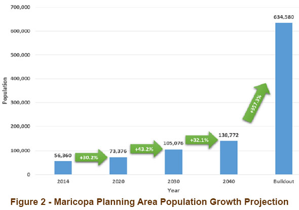
Maricopa is expected to be home to over 124,000 people in the year 2040, with almost 140,000 people living within the planning area. The ultimate buildout population of the planning area is difficult to project as specific areas remain unplanned. However, MAG estimates the total population of the planning area near 635,000. MAG growth models anticipate growth rates of population (Figure 2) and housing (Figure 3) are comparable between now and 2040, both showing the greatest percent change occurring between years 2020 and 2030.

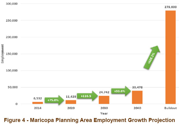
Employment growth (Figure 4) is expected to occur at a slower rate than population and housing growth, which reflects the community’s continued reliance on the Phoenix metropolitan area and other locations for jobs. The greatest growth in employment is projected to occur between 2030 and 2040. Implementation of this General Plan is intended to balance the rate of population growth with the rate of new employment.
At present, the City of Maricopa has entitled active developments that include approximately 11,000 undeveloped residential single-family production home sites (number excludes planned developments not in the platting process). The projected growth rate and annual new home permit averages suggest this inventory could be depleted sometime between 2025 and 2031. The available lot inventory is generally limited to single-family detached homes on lots averaging 5,000 to 8,000 square feet and does not provide a variety of housing choices such as large lots, custom home-sites, small lot clustered homes, or attached housing. Maricopa residents have a continued vision for a diversity of housing types to meet the needs of the changing demographics of Maricopa. For additional details, refer to the Housing Element discussion, Section II B2.
2. Growth Strategy
Changing demographics, community needs, and land resources, require that the City’s long-term development plans can accommodate existing and future needs. These shifts create the need to ensure a balanced mixture of uses, adequate support resources, and proper ratio of people to jobs, fiscal efficiency, and environmentally sustainable principles. Consistent with Smart Growth principles, Maricopa residents envision the future of the City to be developed in a pattern that can better adapt to trends and evolving lifestyles. The development of Maricopa as a collection of strategically located mixed-use Village Center areas (refer to Section II. B1. a. Village Planning & Village Center Development Pattern) with full service commercial and employment centers offers a dynamic growth pattern that is much more resilient than a typical low density homogenous development pattern. This perspective compliments the City of Maricopa’s strategy for creating a sustainable future with a variety of uses and housing choices. The Village Planning and Village Center concept is already underway in Maricopa with plans for the redevelopment of the Heritage District and the development of the City Center area. The Village Planning and Village Center growth pattern is further discussed in the Land Use Element and reinforced throughout this General Plan.
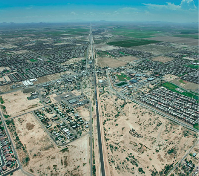 Current land use in Maricopa is predominantly single-family homes of a very similar format with a healthy supply of lots for new single-family homes, as described in the previous section. Future growth will need to balance this abundance of a similar residential use to grow with an integrated full- service economy. Maricopa residents are eager to experience more local options for shopping, entertainment, housing choices, recreational opportunities and transit options. They are an educated population who also desire local employment options that meet their education and experience levels. The City works to partner with others to create quality mixed use development space to meet these demands.
Growth areas have been identified that allow the city to capitalize on and leverage existing public infrastructure, such as water and sewer utilities and completed roadways, bridges, and intersections. Development requiring new public infrastructure extensions and maintenance to meet adequate levels of service and public safety access should be discouraged unless mechanisms are in place to alleviate the additional burden to public services (refer to the “Efficient Utility Planning “ and the “Density to Cost Ratio” discussion in Section II. H.3.).
The Growth Area Map shows the undeveloped or under developed areas desired for a mixture of uses in close proximity to existing public facilities and the transit corridor. Growth is encouraged in these areas to utilize the existing and planned transit services, water and wastewater infrastructure, telecommunications, electrical services, and public safety. Additionally, these areas are located in close proximity to the existing commercial retail corridor offering direct access to shopping, recreation and entertainment with limited reliance on the personal automobile. Refer to other elements for the various goals and objectives supporting development along the transit corridor.
a. Commercial & Employment Growth
The City has a continued emphasis on job creation, enhanced retail, and healthcare services reflective of the public visioning aspect of the Maricopa General Plan. Commercial Land Uses are focused around SR-347, portions of the Heritage District, various arterial corridors and along the major transportation corridors. Employment land uses are focused primarily along the major transportation corridors of Maricopa-Casa Grande Highway/Union Pacific corridor, the SR-238 corridor, and the Ak-Chin Regional Airport area. A concentration of employment and mixed use activities are also designated along SR-347 south of Ak-Chin and near several Village Center nodes identified in the southern portions of the planning area. With respect to public transit, the specific strategy considers high volume transit service corridors as opportunities to stimulate and support commercial and employment expansion.
Two large tracts of employment are the Volkswagen and Nissan test facilities, which are relatively low intensity land uses. In 2007, Volkswagen amended the General Plan Land Use map from Employment to Master Planned Community in preparation to relocate operations and allow for redevelopment of the site. Volkswagen chose to stay at the present location and continues to expand facilities and operations. Figure 7 - Land Use Map, and Table 7 are noted accordingly (Objective F2.1.2 discusses automotive industry uses in the City.) These areas are not presently identified as current Growth Areas, however, local employment and expansion of the economy is critical to the City’s economic health. New employment development opportunities should be carefully considered when out of proximity to existing infrastructure and services. Innovative facilities and public service solutions are necessary to overcome the lack of infrastructure in underserved areas.
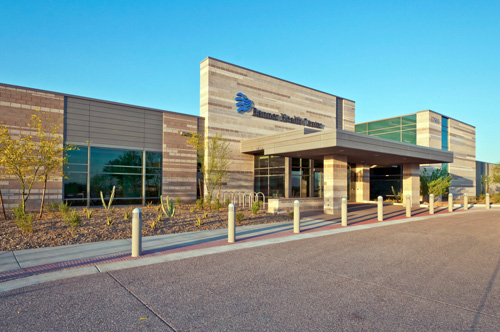 60% of existing local businesses in Maricopa are home occupation businesses. This is a very unique scenario embraced by the City, in part due to the limited availability of commercial office space. The City has implemented flexible Zoning Regulations to allow home occupations to grow while maintaining the residential character and compatibility with neighborhoods. Additionally, the City has implemented a Home Based Business ordinance to encourage the transition of homes within the Heritage District for business uses. The City will need additional office space to locate and retain home occupation businesses as they grow beyond what homes can accommodate.
In addition to creating concentrated mixed use Village Centers, Maricopa citizens also envision the development of large destination commercial and retail centers along transit corridors, and the development of industrial and business parks for local business and employment opportunities. Smaller scale shopping centers and convenience shopping and services are desired in close proximity to, or integrated within, existing and future neighborhoods.
| Goal A1: |
Designate and plan for mobility, transit, and transportation corridors to facilitate future development in accordance with the Future Land Use Plan. |
| Objective A1.1 |
Establish public policies that protect areas designated for business and employment from incursion by incompatible land uses such as single-family residential. |
| Objective A1.2 |
Institute policies that maximize site development potential for mixed use infill areas to increase usable building and gathering spaces and encourage transit ridership. |
| Objective A1.3 |
Implement the long range goals and strategies of the Transportation Master Plan. Designate future high volume transit corridors, such as southern SR-347 as opportunities for commerce and employment. |
| Objective A1.4 |
Recruit appropriate businesses and development along these corridors. |
| Objective A1.5 |
Coordinate public and private planning of infrastructure to ensure that business parks and business neighborhoods may develop and grow. |
Table 6 summarizes growth assumptions derived from 2040 MAG Regional Travel Demand Socioeconomic Data and trends in employment use-based building square footage. These assumptions keep with planning policies supporting managed residential, employment and commercial growth. The Plan’s 25-year projections are based on the continuance of current growth patterns which are driven by the housing market in Pinal County and Maricopa, reasonable access to SR-347 & Maricopa-Casa Grande Highway, land availability, and other factors. Population projections utilize 2.8 persons per dwelling unit and sustained growth to reach Year 2040 anticipated population of 138,700 for the Maricopa Planning Area.
Table 6 – 2040 Planning Area Growth Assumption
|
2015 |
2020 |
2030 |
2040 |
| Population Estimate |
57,000 |
73,400 |
105,000 |
138,700 |
| Dwelling Units |
22,200 |
25,600 |
37,000 |
50,000 |
| Employment |
6,500 |
11,500 |
25,000 |
40,000 |
| Commercial, Office, Industrial (sq. ft.) |
1,055,800 (actual) |
2,300,000 |
5,000,000 |
8,000,000 |
| *Figures provided by MAG Socioeconomic Data and City of Maricopa (Avg. 200 sf per employee). |
| Goal A2: |
Achieve a balance in the community between jobs and housing. |
| Objective A2.1 |
Support land use requests that improve the balance between housing and employment within the Maricopa Planning Area. |
| Objective A2.2 |
Assure that sufficient infrastructure is in place or necessary improvements are adequately planned and funded (i.e. remove from Vekol Wash, floodplain, adequate sanitary sewer and water supply). |
| Objective A2.3 |
Encourage, through land use controls, the development of hospitality uses including hotels, resorts and restaurants. |
| Objective A2.4 |
Evaluate and update the General Plan Land Use Map with a defined scope and objectives. Include an analysis of existing zoning and the various PAD planned land uses within the City and Planning Area, and outline recommendations for Land Use Map updates in support of this General Plan and the 2040 Vision. |
b. Residential Growth
Residential growth through 2025 is designated for undeveloped and under-developed areas west of White and Parker. Through the community visioning process, residents envision certain areas of the City to rezone to allow mixed-use, live/work, and higher density housing consistent with the Redevelopment Area Plan and future infill strategies (2040 Vision Housing strategy). Particular importance is directed towards revitalizing the Heritage District area where incentives for investment such as regulatory flexibility, acts to support mixed-use development, and maintenance of desired character may be readily achieved. In 2014, the City implemented zoning districts and redevelopment policies: Mixed Use Heritage (MU-H) and Transportation Corridor (TC) Overlay Districts, to create a mechanism that allows a mixture of uses, higher density housing choices, and transit oriented development within the redevelopment area. An update to the 2008 Redevelopment Area Plan is necessary to further this strategy and effectively guide the comprehensive redevelopment of this key area of the community.
The Land Use Map identifies Village Center areas for higher density and more intense mixed-use development. The Village Center concept is further discussed in the next section, Land Use Element. Village Center planning is designated for areas near transit corridors and high capacity arterial intersections, such as the Heritage District (SR-347 & MCG Hwy), and the City Center Area (CAC / San Travasa) along White & Parker to introduce pedestrian-friendly spaces and encourage transit ridership.
c. Annexations
As a thriving community, Maricopa understands that growth is inevitable. Maricopa pledges to work with all landowners to support annexations that facilitate logical expansion of our boundaries in order to advance quality development. Input received from residents and stakeholders in Maricopa’s Planning Area suggest that many residents desire not to annex into Maricopa. The existing residential areas, such as Thunderbird Farms, Hidden Valley and other rural enclaves provide a needed alternative to the neighborhoods and housing stock available within Maricopa. Preserving these rural enclaves while maintaining and enhancing their unique character is important to Maricopa and the future of Western Pinal County.
The City also supports the preservation and enhancement of commercial agricultural operations and industrial activities, such as the Nissan proving grounds. These uses are valuable assets to Western Pinal County and Maricopa supports these activities to operate safely and successfully, now and into the future. Future requests to annex land into Maricopa must be found to further the goals and objectives of this General Plan.
| Goal A3: |
Evaluate annexation of land to accommodate the City’s projected growth. |
| Objective A3.1 |
Adopt a Comprehensive Annexation Plan. |
| Objective A3.2 |
Consider expanding the limits of the City south, west of the Ak-Chin Indian Community along the I-8, as well as the future I-11 corridor. |
| Objective A3.3 |
Ensure that smart growth concepts are applied to developments planned for annexed areas. |
| Objective A3.4 |
Consider opportunities for loop parkways to provide greater mobility and connectivity within the community and to the greater region. |
Sections of this Element:
- Development Pattern
- Housing Element
- Rehabilitation & Redevelopment
- Special Planning Areas
- Neighborhood Preservation and Revitalization
The purpose of the Land Use Element is to guide development and re-development in an orderly manner and balance growth with preservation of the community’s assets. The General Plan designates the location and extent of private (residential, commercial, industrial) and public (education, recreation, open space) land together with the density and intensity for land use categories. The aim is to foster growth in the Maricopa economy with thriving neighborhoods that are integrated with, and highly accessible to, good jobs, shopping, amenities and recreation.
Planning considerations include managing continued residential growth, striving for economic development, and influencing thoughtful land use decisions in the City and beyond, in the Maricopa Planning Area. The residents believe in achieving a balanced and accessible community with educational excellence, safe neighborhoods, and a strong business community. To this end, the citizenry encourages growth in a pattern consisting of a collection of community villages, each anchored by mixed-use Village Centers along transit corridors with concentrated shopping, employment, a variety of housing choices, and amenities.
1. Development Pattern
a. Village Planning & Village Center Development Pattern
The citizens of Maricopa envision a carefully planned and well-designed City that is amenity driven with balanced development in all sectors: diversity of business and industry, well-planned open spaces, and integrated amenities. Since the 2006 General Plan, Maricopa citizens desire to grow with an emphasis to create a more sustainable development pattern that appeals to residents and a broad demographic. At that time, a goal objective was to “establish disbursed employment areas and Mixed Use activity centers.” More recently, through the 2040 Vision Strategic Planning process, citizens envision Maricopa developing as a collection of multiple village areas each with mixed-use Village Center cores anchored with commercial and employment centers served by restaurants, retail shopping and cultural opportunities such as art districts and galleries.
2040 Vision:
Identify and develop multiple mixed-use village core areas with commercial and employment centers served by restaurants, retail shopping and cultural opportunities such as art districts and galleries.
Village Centers are higher intensity locations within a distinct geographic area along transit corridors and are a cluster of community oriented neighborhood character areas with local commercial, office, and mixed use spaces. These centers should contain public gathering spaces with civic uses, such as schools, libraries, and parks and have a distinct identity and village theme. Uses will be integrated to the maximum extent possible in order to encourage a pedestrian-oriented design and transit ridership. The future Village Centers will be served by a robust transit system and provide a variety of housing types appealing to a broad demographic. The Village Center development pattern offers a more sustainable land use strategy, a strong sense of community, pedestrian oriented commercial nodes, mixed-uses, employment, entertainment, and local services. It also appeals to people who cannot or prefer not to drive as a primary means of transportation, such as the Senior population and younger generations.
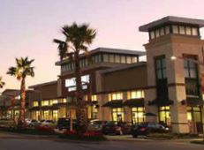 The villages will aim to have a proper job-to-housing balance, a neighbor-hood and community-based organization system, a synergy with the City to improve communication and a successfully operating multi-modal transportation network. Each of the villages will provide opportunities for people to live, work, and play. This development pattern centers on what the local residents love about their neighborhood while setting measures to ensure those special characteristics are enhanced and preserved. Following Smart Growth principles, Land uses should be concentrated within a 1⁄4 to a 1/3 of a mile from the primary transit stop of the Village. Ideally, land uses become less intense moving away from the Village Center with low density residential, large lots and agricultural uses around the fringe of the village.
“The Urban Land Institute (largest international organization representing the development industry) and the National Home Builders Association have promoted the advantages of mixed use development over the last 20 years and this concept has more recently been embraced as a “smart growth” strategy. Mixed use developments incorporate residential units, commercial properties, and employment uses. These areas may also contain cultural amenities such as performing arts centers, entertainment venues, museums, education and training centers, and community gathering places. Mixed use developments allow residents to minimize and shorten trips by clustering multiple services and activities and by supporting alternatives to automobile transportation. Focusing development on activity centers can reduce sprawl, conserve open space and protect irreplaceable natural resources on the urban fringe. Compact community and building design means less land required for construction. This approach also reduces energy needed for transportation, transporting water and providing other services, while reducing the carbon footprint, urban heat island effect and environmental impact.” -Pinal County Comprehensive Plan
 The most current plans and policies of the City reflect the village concept and reinforce this vision. The Parks, Trails and Open Space (PTOS) Master Plan offers guidance for planning parks, trails and recreation needs for the Maricopa Planning Area based on the village development pattern. The PTOS Master Plan is in the process of an update and will further evaluate village areas and future plans for open space and connectivity amongst the villages. The PTOS Master Plan update will further build upon the connectivity and policy framework outlined in the Transportation Master Plan for seamless land use policy to achieve the Village Core concept envisioned by residents.
The 2014 Zoning Code Rewrite Diagnosis & Evaluation Working Paper makes recommendation for the creation and implementation of a Village Planning Committee organizational structure. This structure is implemented in larger communities to offer residents additional avenues for public input and communication on projects affecting specific locations (or “Village”). The Village Planning Committee would act as an additional advisory body to the Planning & Zoning Commission and City Council, as well as an additional conduit to city leadership on local planning issues. This concept should be further explored to offer area specific guidance as the City grows and planning matters become more complex and area specific.
The 2013 Pinal County Comprehensive Plan Update identifies mixed use “Activity Areas” within the City of Maricopa incorporated limits and the municipal planning area. The Comprehensive Plan suggests the City and planning area should grow with concentrated mixed use activity nodes.
Two areas within Maricopa’s incorporated boundaries are identified for Village Center development on the Future Land Use Map. The Heritage District and Redevelopment Area is identified as a mixed use Village Center and is further discussed in the Conservation, Rehabilitation and Redevelopment Element. The second location is the City Center area including CAC and the San Travasa mixed use development. The City Center area is programmed to develop as a village center anchored by the City Hall and civic uses integrated with mixed uses, office employment, and large public gathering spaces. The City Center was planned through a public visioning process and will require refinement through an Area Specific Plan. The City Center area is further discussed under Special Planning Areas of this section and with the Public Buildings Element.
| Goal B1.1: |
Identify and implement policies to develop multiple mixed-use village core areas with commercial and employment centers served by restaurants, retail shopping and cultural opportunities such as art districts and galleries. |
| Objective B1.1.1: |
Incorporate appropriate village center development within the various community Master Plans. Update Master and Strategic Plans, such as the PTOS and the Redevelopment Area Plan to provide policy guidance to reinforce the Village Center development pattern. |
| Objective B1.1.2: |
Encourage certain areas of the City to rezone to mixed-use and higher density housing consistent with redevelopment plans and General Plan land uses. |
| Objective B1.1.3: |
Incorporate appropriate village center development within the various community Master Plans. |
| Objective B1.1.4: |
Develop a walkable community with commercial nodes and amenities for residents. |
| Objective B1.1.5: |
Promote commercial and office development in close proximity to neighborhood nodes, along arterials, and other appropriate locations. |
| Goal B1.2: |
Develop Maricopa as a collection of villages and districts with distinct community names, themes, and unique character to reflect the variety of character, culture, and history that makes each area of Maricopa unique. |
| Objective B1.2.1: |
Proactively manage future development and partner with developers to create distinctive communities. |
| Objective B1.2.2: |
Establish entryways, gateways, streetscapes, and other features that distinctively delineate the various village neighborhoods. |
| Objective B1.2.3: |
Create village plans with design standards that address the unique needs and desires of the area residents surrounding the Civic Center and implement strategies to prepare the site for development. Update the Redevelopment Area Plan for the Heritage District Village Center. |
b. Mixture of Uses
 The majority of existing residential planned developments do not provide full service uses in close proximity to homes, creating a dependence on the personal automobile and diminished opportunity for alternatives. Maricopa’s 2040 Vision encourages mixed-use development to integrate land uses, enhance connectivity between uses, and improve infrastructure efficiencies. Creating multi-modal access to goods and services in close proximity to homes and neighborhoods reduces reliance on the automobile and improves community health, social interaction, and preserves resources. The City desires innovative development that integrates a mixture of uses with an emphasis on pedestrian orientation, sense of place, and is designed to increase ridership along mobility and transit corridors.
| Goal B1.3: |
Encourage mixed-use development. |
| Objective B1.3.1: |
Encourage the location of neighborhood commercial and mixed uses adjacent to or within residential communities. Implement 2014 Zoning Code provisions to encourage the infill of existing residential areas with neighborhood serving commercial uses. |
| Objective B1.3.2: |
Encourage developers to take advantage of opportunities provided by mixed-use standards especially within the designated redevelopment areas and along transit corridors. |
| Objective B1.3.3: |
Promote a variety of commercial and retail spaces to expand opportunities for small businesses. |
| Objective B1.3.4: |
Implement mixed-use and transit oriented zoning districts to permit developments with densities and building heights in appropriate locations to create a more sustainable and pedestrian-oriented urban form. |
| Objective B1.3.5: |
Establish guidelines for the appropriate inclusion of green spaces, paths and other people- oriented amenities. |
| Goal B1.4: |
Minimize conflicts between land uses. |
| Objective B1.4.1: |
Address land use compatibilities and incompatibilities when considering zone changes and development approvals. |
| Objective B1.4.2: |
Apply buffer codes to establish transitions that include open space and landscaping between substantially different land uses. |
| Objective B1.4.3: |
Based on noise, vibration and safety concerns strongly discourage residential development adjacent to high capacity roadways, airports, and railroad corridors. |
| Objective B1.4.4: |
Minimize air pollution impacts to residential areas and school from smoke, odors and dust generated by industrial land uses and unimproved sites. |
| Objective B1.4.5: |
Update and consistently enforce the community’s development codes, including zoning, subdivision, and related regulations. |
| Objective B1.4.6: |
Transition all property zoning designations from pre-existing districts to existing zoning districts in a manner that best achieves the goals of this General Plan. |
| Objective B1.4.7: |
Seek appropriate buffers and land use transitions along Native American Community boundaries. Support lower density/intensity land uses along Native American Community boundaries, where appropriate. |
| Objective B1.4.8: |
Consider scenic views and impacts to scenic resources in evaluating land use proposals including rezonings and subdivision plats. |
| Objective B1.4.9: |
Avoid conflicts between airport operations and nearby development with specific attention to incompatibilities of residential uses and airport noise and safety. |
c. Other Land Uses
Historically, the Union Pacific mainline created a distinctive ‘edge’ in the southern part of the City. This area south of the railroad has developed in recent years with supportive City wide amenities, such as an expansion to the High School, the development of the Copper Sky Regional Park, Multi-generational Center and Aquatic Center, and the development of single- family residential neighborhoods. Connecting both sides of the railroad is currently and will continue to be a challenge for the community. The City of Maricopa street pattern is dominated by SR-347, a regional north-south transportation corridor, bisecting the planning area and connecting the City to Interstate 10 to the North and Interstate 8 to the South. A grade separation is planned and funded for SR-347 over the UPRR, which will enhance the traffic access, safety, and economic viability of the growth areas south of the rail corridor and Maricopa-Casa Grande Highway.
The Maricopa-Casa Grande Highway and SR-238 also form important corridors in the community, both having intersections with SR-347. SR-84 and Interstate 8 are important east-west arteries in the extreme southern portion of the planning area. These features are further discussed in the Circulation & Connectivity Element.
Land uses and development supportive of an aging population is critically important to Maricopa. Many residents have chosen to retire here and seasonal residents may become permanent, placing a high demand for Senior related services such as health and medical care, living assistance, quality affordable housing, transit, and human services (refer to Public Services). Citizens envision the future of Maricopa to include diverse opportunities for end-of life planning and services. To meet the needs of this population, the City will require fully integrated medical healthcare services at convenient locations, rehabilitation and therapy facilities and end-of-life preparation such as funeral and mortuary services, a cemetery or interment facility. A place to bury and lay persons to rest completes the circle of life and creates a permanent sense of home among residents.
| Goal B1.5: |
Support the availability of burial facilities and encourage the establishment of mortuary services. |
| Objective B1.5.1: |
Utilize zoning and land use plans to allocate space for cemeteries, through private and/or faith-based and non-profit partnerships. |
| Objective B1.5.2: |
Require perpetual-term maintenance, via site insurance or other means. |
| Objective B1.5.3: |
Partner with religious organizations and other support groups to ensure the perpetual quality of facilities. |
| Objective B1.5.4: |
Require perpetual-term maintenance, via site insurance or other means. |
| Objective B1.5.5: |
Recognize and support diverse opportunities for memorialization including traditional plots, columbarium or mausoleums, including in partnership as needed with houses of worship. |
| Objective B1.5.6: |
Encourage organizations to provide locations for memorial service in houses of worship or secular settings. |
| Objective B1.5.7: |
Support regional cremation services. |
Table 4 illustrates the composition of Maricopa’s use of land. In 2005, the land use distribution reflected a predominantly agricultural character (51%) with conversion to residential uses at 25 percent of all lands. As of December 2015, the data shows the allocation of land use is predominantly Master Planned Community and Medium Density Residential (56%) with limited agriculture (5%). However, much of the residential and master planned community designated lands are still farmed with the anticipation to develop as residential in the future.
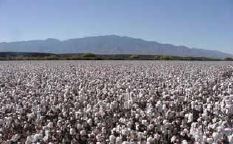 Service-based land uses and commercial uses are lagging behind residential construction. The table includes public/institutional land uses (8 percent), which consist of schools, public parks, and public facilities. Industrial, Employment, and R&D uses represent 21.6 percent. It should be note that the Volkswagen Test Track facility is an industrial use and occupies almost 5% of the incorporated area. The test track is designated for Master Planned Community in anticipation of development in the future. Commercial and Mixed Use sites have grown from about one percent in 2005, to almost seven percent. These land uses are primarily focused along the SR-347 corridor and the Heritage District area at the Smith-Enke and SR 238 intersection. The Seven Ranches area is designated for Mixed-Use, but requires further planning and studies to determine feasibility and the community’s desire for this area.
Table 7 – Incorporated Area Land Use Composition
| Land Use |
% of Total |
Acres |
| Rural |
0.47% |
162 |
| Low Density Residential |
3.11% |
1,077 |
| Medium Density Residential |
23.81% |
8,257 |
| High Density Residential |
0.31% |
107 |
| Master Planned Community* |
31.82% |
11,035 |
| Mixed Use |
2.62% |
909 |
| Commercial |
4.15% |
1,440 |
| Agriculture |
4.23% |
1,466 |
| Light Industrial |
0.25% |
88 |
| Employment * |
20.60% |
7,144 |
| Research/Development |
0.71% |
246 |
| Public/Institutional |
3.25% |
1,129 |
| Park/Open Space |
4.68% |
1,625 |
| Total |
100% |
34,684 |
| * VW Test Facility is Employment Use, although designated as MPC |
| * VW Test Facility is 1628 Acres / 4.69% of land within the City Limits |
Data from December 2015, City of Maricopa Planning Division.
| Goal B1.6: |
Coordinate land management and planning activities with neighboring Indian Communities, Federal, State and private interests. |
| Objective B1.6.1: |
Participate in regular meetings with Ak-Chin and Gila River Indian Communities to address land use and transportation issues and concerns. |
| Objective B1.6.2: |
Communicate City general development priorities and goals in working with developers, landowners, Pinal County and State of Arizona officials. |
| Objective B1.6.3: |
Monitor development applications in the unincorporated portions of the Planning Area. |
| Objective B1.6.4: |
Facilitate the coordinated planning and reasonable development of State Trust Lands in the Maricopa Planning Area. |
| Objective B1.6.5: |
Support the creation of functional master plans for regional systems including flood control and transportation. |
| Objective B1.6.6: |
Encourage and support the development of public information materials regarding respectful interaction and travel within nearby Native American communities. |
Sources of Aggregate
Growth and development requires building materials for everything from streets and landscaping to buildings. Ensuring that Arizona has adequate resources to provide these necessary materials was one of the main reasons behind a new requirement that cities begin to plan for sources of aggregate and incorporate into their general plans.
The passage of the Aggregate Protection Act (Senate Bill 1598) added a provision in the Arizona Revised Statutes (9-461.05C.1.g) that requires cities to address sources of currently identified aggregates. In addition, cities are to provide policies to help preserve currently identified aggregates sufficient for future development, and policies to avoid incompatible land uses in the Land Use Element of their General Plan.
Upon inspection of the registered Arizona State Mine maps, Arizona Geological Survey, and Arizona Department of Mines and Mineral Resources, no aggregate resource activities by State definition are present in the Maricopa Planning Area. In the event sources of aggregate mining are planned in the future, the General Plan Land Use Map will require amendment to recognize new mining sites. The following Goal and Objectives address the State requirements for the City of Maricopa:
| Goal B1.7: |
Provide equal protection for residential development and aggregate mining operations. |
| Objective B1.7.1: |
Discourage new residential zoning where future residences would be adjacent to an existing or planned aggregate / mineral mining operation. |
| Objective B1.7.2: |
Discourage new residential zoning where future residences would be adjacent to an existing or planned aggregate / mineral mining operation. |
| Objective B1.7.3: |
Promote non-residential development such as business park and industrial uses adjacent to planned mining operations. |
d. Land Use Plan
The land uses shown on the General Plan Future Land Use map are grouped into thirteen generalized land use categories. The following categories describe the Land Use designations used in the City’s General Plan. These designations do not represent zoning districts; however, they generally correspond with the zoning districts found in the City of Maricopa Zoning Code (refer to Table 8 - Land Use Designations). The City acknowledges that the General Plan contains land use designations, transportation corridors, village core and resort designations, which may conflict with existing zoning and entitle-ments for some parcels within the City limits, and for some parcels with existing County zoning and entitlements within the City’s planning area. In such cases the existing zoning and entitlements shall take precedence over the General Plan Land Use designations an conceptual transportation corridors.
No General Plan Amendments will be required to develop parcels consistent with the existing zoning or entitlements, and the General Plan shall not be used to prevent amendments to existing zoning or entitlements which are consistent with the overall character of the existing zoning and entitlements that would not be otherwise necessitated by the General Plan Amendment criteria contained herein. The City will evaluate existing zoning approvals and the Future Land Use Map designations, including future transportation corridors, to define a clear scope and program to amend the City’s General Plan Future Land Use Map to address inconsistencies between approved zoning and future land use design ations (refer to Goal Objective A2.4).
Land Use Designations:
AG – Agriculture
Purpose: The Agriculture category recognizes farming and other agriculture as one of the principle land uses in the planning area. Agricultural uses have impacts to immediately adjacent properties making lower intensity land uses such as large lot, single-story residential appropriate transitions adjacent to agriculture. The density range of this category, in accordance with statutory requirements, is up to 1 residence per acre; however, the continuation of lower densities as required by existing zoning is supported.
R – Rural
Purpose: The Rural category promotes the continuation of the rural character that is common across much of the planning area. Rural areas may include farming and small scale livestock operations along with low density residential and other uses defined in the Zoning Code for the respective Zoning District. Public infrastructure and services are not required at a level as great as in higher density development. Several rural enclaves exist in the planning area and should be preserved. The density range of this category is less than 1.0 dwelling unit per acre.
L – Low Density Residential
Purpose: The Low Density Residential designation accommodates semi-rural large lot development with generous distances to streets and between residential dwelling units and a viable semi-rural character setting. Limited livestock privileges may be a part of this character for areas where lot sizes are a minimum of one acre. Areas in this category are generally larger lots with accessory structures that may be used for animals. The maximum density for this land use category is 2.0 dwelling units per acre (du/ac).
M – Medium Density Residential
Purpose: The Medium Density Residential category provides for a suburban lifestyle with planned, single-family residential neighborhoods, which include significant open space, recreation and cultural opportunities, including schools, churches and neighborhood facilities. Medium density residential developments are expected to contribute to off-site infrastructure needs for which they create a demand including roadways, bridges and grade separated crossings. Medium density residential areas comprise the majority of residential land in the City. The density of this land use category is between 2.0 to 6.0 du/ac.
H – High Density Residential
Purpose: The High Density Residential designation provides for multi-family dwellings that may be multi-story buildings. This category would provide for townhouses, condominiums and apartments. Substantial common open space, recreational amenities and on-site support facilities would serve residents. Such high density uses may be appropriate in the Mixed Use category. The density range of this land use category is 6.0 or more dwelling units per acre.
VC – Village Center
Purpose: The Village Centers are the highest intensity urban area of the City, generally developing near intersections with regional importance for transit and connectivity. They are characterized by a cluster of community and neighborhood oriented areas with local commercial, office, entertainment, recreation, and mixed use spaces serving the day to day needs of the surrounding groups of neighborhoods. These centers should contain public gathering spaces and/ or civic uses with a character and identity that reflects the special character of the area. Uses will be integrated to the maximum extent possible in order to encourage a pedestrian-oriented design and transit ridership. The density range should exceed 18 dwelling units per acre when located within a 1⁄4 mile walk to a transit station or stop.
MU – Mixed Use
Purpose: The Mixed Use designation is intended to foster creative design for developments that desire to combine commercial, office and residential components. Single use projects are discouraged in the MU designation. Proposed MU projects should provide a true combination of uses that inter-relate in design and function with a pedestrian oriented environment. Higher density residential products (such as apartments and condominiums), 8.0 or more dwellings per acre, are expected in Mixed Use projects.
MPC – Master Planned Community
Purpose: The Master Planned Community designation provides for large-scale (160 acres or more) master planned developments that include a true variety of residential products, including larger lots and smaller, attached housing, along with supporting commercial and employment land uses to meet the daily needs of the residents. Residential areas are to include adequate open space, schools, churches and neighborhood facilities. Overlay zoning in combination with comprehensive site planning provide for supporting infrastructure. MPC developments are expected to provide off-site infrastructure enhancements as necessary to offset development impacts including needed roadway, bridge and overpass capacity. The overall density is flexible to allow appropriate urban design for properties designated for Village Center. Overall densities for all residential dwellings in MPCs without a Village Center designation can range from 3.0 to 10.0 dwelling units per acre.
C – Commercial
Purpose: The Commercial land use category provides for commercial nodes on individual parcels. The intent is to provide neighborhood and community scale shopping, offices, medical facilities, and subordinate multi-family residential uses which incorporate pedestrian and neighborhood needs through site planning, architecture, access, lighting and parking design. Single-family residential uses are not supported. For larger parcels, over 40 acres, regional retail development is anticipated in this designation.
LI – Light Industrial
Purpose: The Light Industrial category designation is intended to provide areas for the development and perpetuation of light industrial activity involving light manufacturing, assembling, warehousing, and wholesale activities and the associated office space and support uses. Areas designated for Light Industrial have adequate transportation and infrastructure access with an emphasis on minimal conflict with existing adjacent land uses.
R&D – Research and Development
Purpose: The Research and Development category is intended to accommodate a variety of employment and educational uses. Technology centers or campuses that include training, education, testing and secondary manufacturing are encouraged. Research and product development laboratories and related facilities are supported in creating a working and learning center for the community.
E – Employment
Purpose: The Employment land use category is a broad designation intended to accommodate numerous types of development including office, industrial and commercial, allowing for varying scale and intensity of land uses. While industrial, warehousing, manufacturing, processing and non-retail commercial activity are expected, retail and wholesale activity are in no way prohibited from locating in the Employment designation. Preferred uses include lighter industrial use such as light manufacturing and business park development, also professional offices, including medical facilities, clinics and associated office support services. Residential uses are not intended in this designation.
Employment sites are to be integrated, through design, buffering, and siting, with adjacent residential or other activities. Typical developments have their own driveways, parking areas, identification signs and landscaping. Developments with more than one building share a common architectural theme, as well a landscape theme, identification signs, parking and driveways.
P – Public/ Institutional
Purpose: The Public and Institutional category provides for public or institutional uses such as school campuses and their attendant open spaces (playgrounds, ball fields, hard courts, etc.), hospitals, churches, water treatment facilities, landfill sites, public library facilities, City offices, public cemeteries, and infrastructure and utility sites.
O/S – Parks / Open Space
Purpose: The Parks and Open-Space category designation identifies open-space sites and corridors intended for public recreation and resource conservation. The General Plan Future Land Use map does not locate individual neighborhood park sites. The General Plan recognizes the need for parks, recreational areas and open areas, which add to the attractiveness of the community and to the quality of life of the residents. The need for future parks is addressed in the Parks, Recreation and Open Space Element of this General Plan.
Larger open space tracts are identified as future preserves and potentially regional parks, including substantial federal land reserves along the western and southern edges of the planning area.
The O/S designation is consistent with the State’s Open Space Planning law where applied to private and State Trust Lands and includes a maximum development intensity of 1 residence per acre.
Other Plan Designations
In addition to land use categories, the Future Land Use map indicates the potential location for future resort type development. Characterized by high levels of amenities including golf or other major recreational features, the General Plan expects and encourages such uses to locate in the City and the planning area by indicating several potential locations. Other Resort locations are anticipated to be identified as community and market development continues.
Table 8—Land Use Designations
| Land Use Designation |
Residential Density (du/ac) |
Pre- Existing Zoning |
Potential Zoning* |
| AG (Agriculture) |
1 or less |
GR-10
GR-5
GR
SR
SR-1 |
RA
GR |
| R (Rural ) |
1 or less |
GR-10, GR-5
GR, SR, SR-1
SH |
GR |
| LDR (Low Density Residential) |
2 or less |
CR-1A
CR-1 |
RS-1
RS-2 |
| MDR (Medium Density Residential) |
2 – 6 |
CR-1
CR-2
CR-3 |
RS-2
RS-3
RS-4
RS-5 |
| MU (Mixed Use) |
6 – 18 |
TR
CB-1
CB-2 |
MU-N
MU-G
MU-H
TOD’s |
| VC (Village Center) |
18 |
|
MU-G
MU-H
TOD’s |
| HDR (High Density Residential) |
6 - 18 |
CR-4
CR-5
TR |
RM
RH
RMHP |
| MPC (Master Planned Community) |
3-10 Overall Target, Village Center Mixed Use may be greater |
PAD
MPD
All |
PAD |
| C (Commercial) |
NA |
CB-1
CB-2 |
NC
GC
SC
GO |
(Light Industrial)
R & D (Research & Development) |
NA |
NA |
GO
GC
LI
IP |
| E (Employment) |
NA |
CB-1
CB-2
CI-B
CI-1
CI-2 |
GO
GC
LI
GI
IP |
| P (Public/ Institutional) |
0 |
GR |
PI |
| P/OS (Park / Open Space) |
1 or less |
GR |
OS-PR
OS-POS
OS-C |
*Provided as a guide to the City’s current zoning districts. General Plan users are encouraged to contact Planning Division staff to determine appropriate zones for each land use type.
Interactive Maps (GIS)

2. Housing Element
Residential development has boomed in the Maricopa area since 2000. Most of the residential development within the City has occurred along SR-347 beyond the commercial sites and approximately 3 miles to the east, north of Maricopa Casa Grande Highway. Some planned residential areas have emerged east of White and Parker not contiguous to previously developed areas creating expansive gaps in complete infrastructure. This has caused strain on City services and public facilities due to the geographic separation from the existing infrastructure, commercial, and service areas. There are limited roadways, access, and dry wash crossings serving this relatively small segment of the City’s population.
The majority of land within the incorporated boundaries of Maricopa has been rezoned from agriculture to primarily residential communities through the Planned Area Development (PAD) zoning process. These communities are by-inlarge planned for single-family, detached homes on lots averaging 5,000 to 8,000 square feet, excluding a few older areas of the community with a limited number of aging homes. The majority of existing master plans were designed to fulfill the insatiable production home building demand of the 2000’s, prior to the market crash beginning in 2008. In many cases these plans predated the cities Subdivision codes, which would require a variety of housing types for Planned Area Development (PAD) and Master Planned Community (MPC) Zoning requests.
As of 2016, there are approximately 11,000 residential lots in the subdivision platting process in communities that are actively being developed. The average absorption rate suggests this inventory would be depleted between 2025 and 2031. There are over 32,000 total single family lots zoned and entitled. The City has an extremely healthy planned housing supply for single family production homes.
Cluster homes, townhomes, attached and multi-family dwellings along with large lot single-family dwellings were presumed to be included in future development as the local housing market increases in size and complexity. Going forward, great attention should be given to protect parcels zoned for larger lot residential, mixed use, and transitional uses to assure the development of neighborhood employment and housing types other than small to mid-size single-family production homes. Protecting existing zoned land and incentivizing mixed use and non-traditional residential development will offer more housing choices and flexibility for homeowners to make improvements to meet their changing needs.
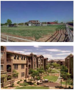 Since Maricopa’s incorporation, citizens demand a broad variety of housing options. This is very important to encourage existing residents to stay within the community and to attract a diverse population to support economic expansion. The City’s housing stock is homogenous, posing a challenge for the future of the City to accommodate existing and future residents, as the population demographics and housing needs are projected to change. The baby boomer population, the largest single family home buyer population in US history, tends to downsize and move to more turn-key housing options such as condominiums, apartments, and full service Senior Living Communities. The millennial population tends to be reluctant to, or has delayed the purchase of a home and prefers a more walkable and socially connected environment with close proximity to goods and services, not unlike the shared amenities and accessibility sought by boomers. Additionally, should a resident wish to downsize to reduce utility costs, maintenance, and upkeep there will be little to no alternatives available and may seek residence elsewhere. Alternatively, an employer wishing to attract unique talent may not be able to compete with other similar companies in competing communities that offer housing choices other than conventional single-family homes.
The City will implement tools and incentives such as Area Specific Plans, the Subdivision Ordinance and Zoning Codes to create housing diversity and set aside land in suitable areas of the community for multi- family, small lot cluster homes, large lots, affordable housing, etc. Not doing so limits the choices and the ability to meet the needs of residents. The City has twenty homes designated for low income families operated by the Pinal County Housing Authority. A Housing Needs Assessment study is necessary to clearly define areas of need and an implementation plan to expand housing options in Maricopa.
| Goal B2.1: |
Partner with developers to identify innovative strategies for providing housing diversity for all ages and income levels. |
| Objective B2.1.1: |
Conduct a detailed citywide housing needs assessment that addresses community needs, diversity, design, housing stock and affordability. |
| Objective B2.1.2: |
Partner with non-profits and private sector to address unmet housing needs. |
| Objective B2.1.3: |
Establish adequate standards and programs to address housing needs in designated redevelopment areas. |
| Objective B2.1.4: |
Evaluate aesthetic design standards for housing to assure the provision of unique and quality housing choices. |
| Objective B2.1.5: |
Encourage certain areas of the City to rezone to mixed-use to permit higher density housing consistent with Master Plans, Strategic Plans, and the Village Center planning concept. |
| Objective B2.1.6: |
Encourage home ownership through workshops and programs for homebuyers. |
| Objective B2.1.7: |
Encourage the development of senior living options such as home modification and assistance programs for agingin-place and the development of communities offering independent living, assisted living, skilled nursing care, and memory care. |
| Objective B2.1.8: |
Expand housing options to include live/work and other mixed-use. |
| Goal B2.2: |
Assure the development of a diverse housing stock in both dwelling type and density. |
| Objective B2.2.1: |
Identify and use available tools, including area specific plans, zoning and subdivision standards, to promote housing diversity in both type and lot size for existing and future PAD’s. |
| Objective B2.2.2: |
Promote higher density infill housing, live/work, and mixed uses in proximity to transit corridors and other appropriate locations. |
3. Rehabilitation & Redevelopment
Rehabilitation & Redevelopment Areas and Special Planning Areas are denoted on the Future Land Use map for key areas in the City that represent multiple development and redevelopment alternatives. Redevelopment improves the quality of the built environment, encourages appreciation for the City’s history and culture, maintains the character and identity of communities, and contributes to the City’s economic vitality. Planning studies have occurred in the past for some areas and are recommended as a prelude to rezoning and/or development approvals. Substantial land use flexibility is preferred in support of the unique development opportunities associated with each area. Appropriate land uses include those furthering the General Plan’s agreed upon Vision, Goals, Objectives and Recommendations.
a. Heritage District Redevelopment Area
The Heritage District Redevelopment Area is the original town site of Maricopa and represents the historical heart and identity of the community. In 2009, a citizen driven redevelopment area plan was adopted setting in motion a unified and cohesive vision for facilitating the long term prosperity, welfare and health of the 3.1 square mile area. The redevelopment area plan provides the community with greater flexibility in encouraging desirable projects with incentives and assistance through Community Development Block Grant (CDBG) funding and other mechanisms, while promoting and facilitating investment and appropriate development in the area. It is critical that this original town site of Maricopa be revitalized to offer a unique urban core experience for residents and visitors. One that embraces Maricopa’s history, culture, and a place where people can live, work and play in close proximity.
The Heritage District is identified as the first mixed use Village Center planning area for Maricopa. An advisory board was created in 2009 to oversee development and revitalization efforts. They are tasked with advising the City leadership on the implementation of the Redevelopment Area Plan, the Heritage District Design Guidelines, and as of 2015 the implementation of the Mixed Use-Heritage Overlay Zoning designation.
The overlay zoning district is intended to allow for the transformation of the Heritage District into a vibrant, pedestrian-oriented, mixed use neighborhood, consistent with the Redevelopment Area Plan, the Heritage District Design Guidelines, and mixed use development standards. The adaptive reuse of existing buildings for residential and commercial uses is supported with a focus on active home based businesses, storefronts, and where viable, upper-floor residences and pedestrian and transit-oriented development to encourage pedestrian activity and connectivity to adjacent areas.
The City will take deliberate actions to develop the Heritage District with a strong identity as a mixed use urban core for the City which reflects the rich culture and historical character of Maricopa. The ultimate goal is to encourage diverse and attractive redevelopment that supports a mix of residential, pedestrian, and neighborhood serving uses in order to achieve an active social environment within a revitalized streetscape while also respecting the existing character.
The Redevelopment Area Plan requires an update to address new opportunities resulting from various changes that have occurred in this area. Refer to the Economic Development and Circulation & Connectivity Elements for additional goals and objectives addressing the redevelopment of the Heritage District.
| Goal B3.1: |
Update and implement the Redevelopment Area Plan for the Heritage District, to reflect changes impacting the area and to integrate the SR-347 Overpass design and alignment. |
| Objective B3.1.1: |
Redevelopment Area Plan (RDA) update shall also serve as the Village Center Area Specific Plan for the area. |
| Objective B3.1.2: |
Prepare housing inventory and needs assessment for the area independently or in conjunction with a City-wide housing needs assessment. |
| Objective B3.1.3: |
Identify a Redevelopment Area staff liaison/project manager to coordinate multiple department and agency efforts and to communicate with stakeholders, area residents, property owners, and business owners. |
| Objective B3.1.4: |
Consider the RDA direction to rebuild the historic train station as part of the Transportation Center and Amtrak train station. Develop a Transit Center and Park–n-Ride in the Redevelopment Area. |
| Objective B3.1.5: |
Consider opportunities for a Heritage Park / town square in the RDA update. This public/private space could include the Water Tower with linkages to future Amtrak station, a Railroad Heritage Park and Visitor Center, and the relocation of the Zephyr train car as recommended in RDA. |
| Goal B3.2: |
PTOS Master Plan update shall assess needs and provide recommendations for the Heritage District, incorporating the SR-347 Overpass design and alignment. |
| Objective B3.2.1: |
Assess park, recreation, amenities, and trail connectivity for the Heritage District in the PTOS Master Plan Update. Provide connectivity to transit and employment opportunities planned on the adjacent Gin site and the surrounding properties. |
| Objective B3.2.2: |
Identify funding sources and mechanisms to support capital improvements. CDBG funds should be designated for Capital Improvement projects within or in support of Heritage District redevelopment. |
| Goal B3.3: |
Prepare and implement a Capital Improvement Plan for the Heritage Redevelopment Area. |
| Objective B3.3.1: |
Implement a Capital Improvement Plan for the Redevelopment Area, including: removal of properties from the 100 year floodplain; Adequate wastewater sewer facilities; complete streets roadway standards; Gateway entry theming and improvements; themed street lights and signage; parity for adequate levels of service equal to other areas of the City. |
| Objective B3.3.2: |
Identify funding sources and mechanisms to support capital improvements. CDBG funds should be designated for Capital Improvement projects within or in support of Heritage District redevelopment. |
| Objective B3.3.3: |
Develop community enhancement programs, such as the façade improvement programs. Eliminate or completely screen outdoor storage areas and other visual nuisances from public rights of way and monitor them for health and safety hazards. |
| Objective B3.3.4: |
Receive a 100 year water certificate for Heritage District properties to remove barrier for future subdivisions and vertical condominium regimes. |
| Objective B3.3.5: |
Develop Entryway / Gateway Identity and sense of arrival for the Heritage Area using art and elements that reflect the community Heritage in the 347 Overpass design. Improve intersection entrances into Heritage District area to strengthen sense of arrival and reinforce the unique identity of the area. |
| Objective B3.3.6: |
Require demolition of all vacant and boarded up buildings with no plans for reuse after a specific time period. |
| Goal B3.4: |
Prepare and implement an economic development strategy for the Heritage District to synchronize with other plans and policies that encourage redevelopment, new facilities, jobs, and incentives to attract investment. |
| Objective B3.4.1: |
Economic Development strategy should promote Heritage District as a “favored” location for new development. Develop a tool bag of incentives and resources to help residents, business owners, and potential developers upgrade and expand existing businesses. Consider flexibility in codes for redevelopment in Heritage Area and incentives to encourage investment, such as property tax relief, temporary sales tax relief, etc. |
| Objective B3.4.2: |
Create a distinct Heritage District Village brand and marketing plan that encourages investment to promote home based businesses, adaptive reuse, and redevelopment opportunities for the area in accordance with applicable land use policies. |
| Objective B3.4.3: |
Investigate, identify and secure funding sources, including partnerships, for grants and loans that support economic development programs for redevelopment and revitalization. |
b. Seven Ranches Area
Historically a rural residential enclave, the Seven Ranches has been broken into smaller land parcels creating significant obstacles to any coordinated development other than low density residential. Property maintenance and aesthetic issues serve as a disincentive for investment. The General Plan supports consolidation of smaller parcels to foster orderly redevelopment. For smaller parcels, low density residential is encouraged, while consolidated, non-residential development and related rezoning requests on parcels five acres or greater should be supported. It should be noted that Seven Ranches is only one of two large lot residential enclaves in Maricopa that offer an alternative housing choice to conventional single family production home sites.
In recent years, a number of abutting lots in Seven Ranches have been purchased by entities, potentially easing future coordinated development efforts. Parcels fronting Honeycutt road have been rezoned for commercial uses, though no new development has occurred. Honeycutt roadway was widened to its full improvement in 2015. Sanitary Sewer does not exist for the Seven Ranches properties and there is limited water pressure available for fire suppression.
In 2012, the City was fortunate to be selected and receive a preliminary planning evaluation and assessment for Seven Ranches from the American Planning Association. The Community Planning Assistance Team (CPAT) organized a citizen led community visioning and planning process resulting in a final report. The CPAT provided a summary of recommendations to address roadway needs, drainage, and recommended development scenarios for further exploration.
| Goal B3.5: |
Prepare a comprehensive Area Specific Plan to guide future land use, design, and necessary improvements of the Seven Ranches area. |
| Objective B3.5.1: |
Build upon the CPAT Final Report and revisit the community visioning and engagement process to determine desires of stakeholders and residents for further planning efforts. This could include the creation and appointment of a Seven Ranches Advisory Group. |
| Objective B3.5.2: |
Further analyze opportunities and constraints, develop alternatives, and prepare a comprehensive land use and infrastructure plan to assess future development proposals and capital improvements. |
| Objective B3.5.3: |
Require demolition of all vacant and boarded up buildings with no plans for reuse after a specific time period. |
c. Saddleback Estates
Saddleback Estates is located in the southeastern portion of Maricopa. This area is one quarter section of land (or 160 acres) and consists of approximately 60 privately owned parcels. The home sites are on one acre minimum parcels with access from unimproved dirt roads, some through private access easement agreements which have posed access issues in the past. The area is generally characterized by an aging housing stock with many unmaintained properties, outdoor storage and some land uses that appear commercial or light industrial in nature. The roadways in this area have at-grade wash crossings and are subject to flooding, limiting the access during times of inclement weather.
A new single family development is approved abutting the north boundary of Saddleback Estates. The proposed development relies on the Saddleback access ways for secondary emergency access. Roadway dedications are needed to allow City services and improvements to the existing and future homes in this area.
| Goal B3.6: |
Prepare a comprehensive Area Specific Plan to guide future land use, design, and necessary improvements of the Saddleback Estates area. |
| Objective B3.6.1: |
Implement a community visioning and engagement process to determine desires of Saddleback Estates stakeholders and residents for further planning efforts. |
| Objective B3.6.2: |
Further analyze opportunities and constraints, develop alternatives, and prepare a comprehensive land use and infrastructure plan to assess future development proposals and capital improvements. |
| Objective B3.6.3: |
Require demolition of all vacant and boarded up buildings with no plans for reuse after a specific time period. |
4. Special Planning Areas

a. Estrella Gin Site
The Estrella Gin Business Park site is a 50+ acre, City-owned parcel of land located east of the Heritage District within the Redevelopment Area. Planned to be developed through a public-private partnership, it is the City’s flagship project to spur local economic growth. The goal for the business park is to provide employment opportunities for local residents by allowing expanding businesses to remain in the community and to attract new industry to Maricopa. Approximately 40 acres is available for commercial development, which will include a mix of industrial, office and flex industrial space.
b. Copper Sky Mixed Use
In 2010, City leadership undertook community outreach and visioning exercises to capture the citizens desires to assist the planning and design of a variety of City facilities, including a Regional Park, Aquatics Center and a Multi-Generational Center. A result of the citizen outreach process was the 140 acre Regional Parks Master Plan that integrates a Multigenerational Center, Park, and Aquatic Center (now known as Copper Sky Regional Park and Multigenerational Center) with a Police Substation and an 18 acre mixed–use development.
The City opened the Copper Sky Recreation complex in 2014 and is the premier sporting, fitness, recreation and leisure destination in Maricopa (Refer to Parks, Recreation and Open Space & Public Facilities Elements). To take advantage of the regional attractions at the complex, 18 acres of highway frontage has been reserved for future commercial and hospitality development. The vision is to transform the 18 acre property into a high-quality mixed-use destination that compliments the Copper Sky Recreation Complex and delivers significant social and economic impact on the community.
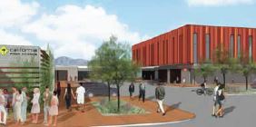 The mixed-use site offers great visibility and access with more than 1,100 feet of frontage on SR- 347, Maricopa’s main retail corridor and north-south connection to I-10 and I-8. The adjacent 120-acre Copper Sky Recreation Complex opened in March 2014 and is a year-round destination for sports, fitness, recreation, and leisure activities. With a projected 500,000 visitors in its first year, it has quickly become the center of activity in Maricopa. The Copper Sky property is further discussed in the Economic Development Element and the Public Facilities Element.
| Goal B4.1: |
Establish a Copper Sky District as part of an effort to develop Specific Area Plans. |
| Objective B4.1.1: |
Work with appropriate Boards, Committees and the Planning & Zoning Commission to create design guidelines that promote and propagate distinct local architecture within the Copper Sky District. |
c. City Center
 In 2010, City leadership undertook community outreach and visioning exercises to capture the citizens desires to assist the planning and design of the City Hall Complex. A result of the citizen outreach process was the conceptual design of the future City Center, which includes a City Hall and spaces for other public buildings and City services, a civic mall open space, a performing arts and cultural center, and a museum all located in the heart of a 145 acre mixed–use development.
In 2013, the City opened the new City Hall and Police Station that was developed on 28 acres of the site, leaving 117 acres of land for the remaining civic facilities and mixed use development. Further planning and entitlement of the property is needed to prepare the site for private development. The City Center property is further discussed in the Economic Development Element and the Public Facilities Element.
| Goal B4.2: |
Establish a Civic Center District as part of an effort to develop Specific Area Plans. |
| Objective B4.2.1: |
Work with appropriate Boards, Committees and the Planning & Zoning Commission to create design guidelines to promote and propagate distinct local architecture within the Civic Center District. |
d. Arizona State Land Development
Within the planning area, there is a mix of land ownership including Arizona State Land Department (ASLD) holdings (See Land Use Map). Since ASLD’s inception in 1912, its mission has been to manage the Land Trust and to maximize its revenues for the 13 beneficiaries of the trust. All uses of the land must benefit the Trust, a fact that distinguishes it from the way public land, such as parks or national forests, may be used. While public use of Trust land is not prohibited, it is regulated to ensure protection of the land and compensation to the beneficiaries for its use.
ASLD held land may eventually transfer to private interests, through sale or lease, for residential, commercial, or employment development, or for agricultural or natural resource extraction uses. State land parcels with high scenic or habitat attributes may be designated or otherwise preserved for conservation pursuant to applicable State laws. The City of Maricopa actively pursues the planning of State Trust Lands located within the planning area and will continue to work closely with the ASLD. It is the intent of the City to work in cooperation with the ASLD to design successful comprehensive land use plans for State Land parcels.
5. Neighborhood Preservation & Revitalization
Maricopa strives to provide a quality physical and social environment for its citizens and places high value on the preservation and enhancement of its neighborhoods. Maricopa citizens stress the importance of neighborhoods and their desire to maintain quality standards and aesthetics. Prior to 2000, the City consisted of three primary neighborhoods – Heritage District area, Seven Ranches, and Saddleback Estates, all of which are discussed for planning and improvements in the Rehabilitation and Redevelopment Element, Section II. B3. These neighborhoods are the highest priority for neighborhood preservation and revitalization efforts.
Maricopa is unique in that the majority of homes are located within planned communities mostly constructed since 2000. These communities exhibit contemporary design principles with interconnected amenities and open spaces, sidewalks and streetlights, community gathering spaces, recreational opportunities, CC&R’s and active Home Owners Associations (HOA).
Moving forward, the City must preserve and enhance the qualities that make Maricopa’s neighborhoods safe, orderly, and vibrant. Close cooperation and coordination with HOA Boards and management companies are crucial to monitoring and improving the well-being of neighborhoods. It will be equally as critical to sensitively revitalize the older neighborhoods to promote redevelopment and improvements that celebrate their unique character, history, and culture. The goals and policies of this element recognize that the preservation and revitalization of Maricopa’s older neighborhoods is critical to maintaining and strengthening the health, safety, prosperity, and enjoyment of the community.
| Goal B5.1: |
Develop and institute a Neighborhood Preservation and Revitalization policy. |
| Objective B5.1.1: |
Utilize existing SmartGOV technology to build processes and procedures to allow the City, HOA Managers, and residents continued assessment of neighborhood needs and activities. |
| Objective B5.1.2: |
Streamline procedures for code compliance to maximize the effectiveness of both City and HOA resources. HOAs and the City have uniquely different and complimentary tools that can be highly effective for preserving a quality neighborhood character. |
| Objective B5.1.3: |
Specific policies, time frames and responsibilities for positive actions to achieve these goals, objectives and recommendations are identified in the City’s CIP and the City Council’s Strategic Plan. |
| Objective B5.1.4: |
Implement rehabilitation, revitalization, and redevelopment for older neighborhoods as prescribed in the Rehabilitation and Redevelopment Element. |
The Environmental Planning & Resource Conservation Element of the General Plan describes City of Maricopa’s efforts in the area of environmental sustainability and provides a framework for development that conserves resources to protect Maricopa’s future. This element addresses protection of air and water quality, land resources, and promoting healthy communities. The policies and strategies in this element are largely broad-based with community-wide applicability. The discussion and strategies are also intended to complement and support those identified in other sections.
Sections of this Element:
- Air Quality
- Floodways
- Energy Element
- Water Resource Element
1. Air Quality
Under the Clean Air Act, the EPA has established air quality standards to protect public health and the environment. Pinal County is ultimately responsible for maintaining compliance with the EPA to attain the National Ambient Air Quality Standards (NAAQS) within Maricopa and the greater planning area. The county maintains monitoring stations throughout the county and in Maricopa to collect measurements of air pollutant concentrations. If the concentrations of any pollutant are found to exceed EPA standards, a formal rulemaking process designates the area as not attaining the standards (non-attainment).
There are some monitors in Pinal County that have exceeded the national standards for three pollutants: ozone, particulate matter, and sulfur dioxide. At lower levels in the atmosphere, ozone is the primary constituent of smog. This is a larger air quality issue in the summer, because the formation of ozone depends upon the presence of sunlight. In Arizona, the summer ozone season begins in April and lasts through September.
Particulate matter includes particles of dirt, dust, soot, smoke, and liquid droplets suspended in the air. Sources include factories, power plants, cars, construction activities, fires, agricultural operations, and windblown dust. Standards for particulate matter are split into two separate criteria based on the size of the suspended particle. The particulates causing concern in Maricopa range in size from 2.5 to 10 micrometers (PM2.5 and PM10, respectively) - many times smaller than the width of a human hair.
Sulfur dioxide is a gas formed from the combustion of sulfur-containing fuels, including coal and oil. Gaseous sulfur dioxide reacts readily with other particles in the atmosphere, creating sulfate particles that can lead to respiratory ailments when inhaled.
Air quality issues are not limited to the physical location of the source and the effects of air pollution almost always cross jurisdictional boundaries. The City of Maricopa is cooperating with Pinal County and the Arizona Department of Environmental Quality to monitor air quality and institute policies to reduce contaminants. As administrator, Pinal County Air Quality Control District enforces new dust control compliance and dust rules effective January 1, 2016 in the West Pinal PM10 Non-attainment Area. This is in part to implement the mitigation efforts as outlined in Pinal County’s State Implementation Plan (SIP).
Maricopa has secured Congestion Mitigation and Air Quality Improvement (CMAQ) Program from MAG and will continue to explore Federal funding as they are made available for local government. Maricopa is also instituting a number of policies to reduce air pollution, including dust control measures, such as paving on temporary and permanent roadways serving new development; instituted a no burn policy; implementing mixed use and Village Center development patterns to concentrate development reducing vehicle trips and emissions; researching clean fuel technologies for City vehicles; expanding local transit services and pursuing regional transit options, and; implementing a complete streets policy to encourage alternative modes of transportation that produce less emissions.
| Goal C1.1: |
Promote local and regional efforts to improve air quality. |
| Objective C1.1.1: |
Improve unpaved roads and areas that contribute to dust pollution. |
| Objective C1.1.2: |
Establish regulations for cattle yards and other industries that may significantly impact Maricopa’s air quality. |
| Objective C1.1.3: |
Amend City Code to give the City the authority to enforce dust and pollution standards. |
| Objective C1.1.4: |
Encourage means to reduce auto ridership through the use of bicycling, telecommuting for City staff, local transit, and mass transit for Phoenix metro commuters. |
| Objective C1.1.5: |
Integrate with the Smart Cities initiatives. |
| Objective C1.1.6: |
Identify and secure funding for Air Quality related programs and improvements. |
2. Floodways & Washes
The City is proactively addressing the physical constraints and potential hazards posed by the floodways in Maricopa. Three significant washes exist in the community: the Vekol Wash and Tributaries, the Santa Rosa Wash, and the Santa Cruz. The Vekol Wash is the only major watercourse with significant riparian areas remaining. As historically an agricultural area, most storm runoff, including the Santa Rosa and Santa Cruz Washes, is conveyed in graded channels.
The City recognizes the importance of these washes to community connectivity, bio- diversity, safety, and the overall landscape aesthetic. Future improvements to City washes will be designed to enhance the washes as an amenity to the abutting developments and the City as a whole. Wash corridors will be designed to appear natural, with pedestrian and bicycle paths for connectivity, direct access to abutting neighborhoods, view corridors from streets, civic uses such as schools and recreation facilities, and serve as habitat and migration corridors for native wildlife. Those portions of the washes that remain natural, such as portions of Vekol Wash, should be preserved as natural areas. The floodplain strategy along with goals and objectives are discussed in the Public Service - Section II. H2.f.
3. Energy Element
The Energy Element of the General Plan addresses the need and opportunity for energy efficient technologies and behaviors. It also promotes the use of clean energy sources, such as solar, wind, geothermal, and biofuels. Due to growing concern over the environmental degradation caused by fossil fuels and the stability of energy supplies, state law requires that every General Plan include an energy element. The element places the City in a stronger economic, environmental, and social position for development in the future.
2040 Vision:
Encourage renewable energy use and long-term environmental stewardship.
The citizens of Maricopa have identified energy conservation efforts to be very important to them and the future of the community. A safe, reliable, and affordable energy supply is important to sustaining Maricopa’s overall health. The City’s demand for energy will increase with projected population growth and increasing environmental awareness may continue to discourage consumption of non-renewable energy sources. Two things should to occur to effectively manage energy efficiencies and control costs: transition to a renewable energy supply and reduce energy demand. Renewable energy systems allow cities to become more independent from the grid and imported fossil fuels, boost the market for renewable technologies, move to more reliable and affordable resources, and display a visible public commitment to a sustainable energy future.
Maricopa has high summer “peak” electricity demands, and implementing small scale renewable energy systems can help protect residents and businesses from the costly effects. In addition, as construction methods and insulation technology continue to improve, so too will our ability to build structures that use less energy, contribute to fewer pollutants to our environment, and improve comfort and productivity. Reduced energy in housing, commercial structures, public facilities, and transportation helps maintain local economic vitality and reduces the need for new infrastructure to deliver energy to the City.
Maricopa has a growing renewable energy portfolio. In addition to ED3’s renewable energy commitment (refer to Energy Utility discussion), the City has attracted one of the few alternative fuel producers in the State. Pinal Energy LLC, a privately held company, is the first and only ethanol production facility to be built in Arizona. The plant plays an important role in improving Arizona’s air quality and makes a local source of ethanol available. Pinal Energy’s annual ethanol production rate is 50 million gallons from roughly 18 million bushels of grain acquired from both local producers as well as from the Midwest. The fuel-grade ethanol is used in blending with gasoline components to produce E10, a 10% ethanol blend. The ethanol produced at the plant is also used for the blending of E85, a clean-burning blend of 85% ethanol and 15% gasoline for use in flex fuel vehicles. Production of ethanol results in two other commercially viable by-products: distiller’s grain and CO2. Distiller’s grain is a feed utilized by dairies and feedlots. The CO2 produced is captured and recycled for use in the Arizona soft drink, dry ice, and hydroponics industries.
The City will continue to promote Maricopa as a leader of alternative fuel technology, research and development, and eliminate barriers that may discourage or limit sustainable energy applications. The City will also take proactive steps to educate citizens on energy conservation techniques.
| Goal C3.1: |
Ensure the City will be well served by regional utility providers that offer alternative, sustainable energies such as solar and wind energy for residential and commercial use. |
| Objective C3.1.1: |
Establish Maricopa as renewable/sustainable energy- friendly and supportive of private investment in residential and commercial solar/ renewable electric and solar/renewable thermal energy. |
| Objective C3.1.2: |
Establish a partnership with utility providers to align priorities, including more efficient and innovative services utilizing renewable resources. |
| Objective C3.1.3: |
Encourage other electric utility providers in order to increase competition and reduce cost. |
| Objective C3.1.4: |
Remove existing barriers to residential solar applications. |
| Objective C3.1.5: |
Integrate with the Smart Cities initiatives. |
| Goal C3.2: |
Encourage renewable energy use and long-term environmental stewardship. |
| Objective C3.2.1: |
Encourage renewable energy, such as solar and wind. |
| Objective C3.2.2: |
Partner with utility providers to develop solar and wind-friendly policies. |
| Objective C3.2.3: |
Examine the feasibility of an energy management system at City facilities. |
| Objective C3.2.4: |
Explore the use of LEED (Leadership in Energy and Environmental Design) technology in future City facilities. |
| Objective C3.2.5: |
Conduct a feasibility study of alternative fuels for City facilities and vehicles and implement existing zoning stipulation for the ethanol plant to work with the City to ensure the residents of Maricopa have access to ethanol fuel E-85 for the Flexible Fuel Vehicles (FFV), or city fleet and other agencies in the city to accommodate year-round suppy of this alternative fuel. |
| Objective C3.2.6: |
Develop specific policy to lessen the City’s carbon footprint and heat island effects. |
| Objective C3.2.7: |
Integrate City energy management with the Smart Cities initiatives. |
4. Water Resource Element
2040 Vision: The City must ensure the availability of developable land and water resources required to meet projected growth and development trends.
The water supply and quality within the City is one of the key elements for maintaining sustainable growth and allowing the City to achieve its development goals. By assessing the water demands needed in the future and identifying and acquiring adequate water resources, the City will be able to plan for and meet the demands of future development. Water is a challenging and complex issue, unconstrained by jurisdictional boundaries and requires regional cooperation and long term planning to be sustainable. The water resources element presents a plan for providing Maricopa’s residents and businesses with a safe, reliable, and high quality source of water beyond 2040.
Maricopa lies within the Arizona Department of Water Resources (ADWR) designated Pinal Active Management Area (Pinal AMA). The Pinal AMA is defined as our local water planning area by the ADWR. The Pinal AMA includes portions of Pinal, Maricopa and Pima Counties in Central Arizona. The Pinal AMA comprises over 4,000 square miles and consists of five groundwater areas, or sub-basins. It includes 275,000 acres of farmland. Water use is over 800,000 acre feet of water per year. (An acre foot covers one acre of land one foot deep, about the size of a football field. It is 325,851 gallons and can supply two urban households annually, both indoor and outdoor usage.)
a. Water Supply
Within the Pinal AMA, the majority of water services in and around Maricopa are provided by a private water company, Santa Cruz Water Company (SCWC) (a subsidiary of Global Water Resources), with the older neighborhoods being served or managed by the Maricopa Domestic Water Improvement District (MDWID). These two entities and the services they provide are more thoroughly discussed in the Utilities Services section. Basically, the water providers supply the potable water to all non-agricultural land within Maricopa, and oversee those properties’ ground water allotment (Designation) within their respective service areas. Prior to subdivision and development, each property is designated an amount of potable water as determined by the ADWR. Upon development and/or subdivision of a property, the property owner must secure a 100 year assured water supply certificate from ADWR to guarantee present and future water availability to sustain the proposed development.
However, within SCWC’s “Service Area Right” (technically known as a Certificate of Convenience and Necessity, or CC&N from the Arizona Corporation Commission (ACC)), a property owner does not have to secure a Certificate of Assured Water Supply individually, as SCWC has a Designation of Assured Water Supply (Designation) for their entire existing and planned service area. SCWC’s existing Designation can support the current customer demand plus projected growth for many years. Through developer agreements, any water rights pertaining to a specific property are utilized to under-pin SCWC’s Designation. To date, only the water rights associated with the 12 square miles of developed property in the City have been conveyed to SCWC’s Designation. In 2014, the total water consumed by all the customers only utilized 25% of the existing Designation. Thus, not only will the current Designation accommodate the City growing significantly in size, but the Designation can continue to grow as new properties develop and water rights continue to be transferred to SCWC for this use.
Growth
Although SCWC is less than half built out within its current CC&N inside the city limits, the utility continues to actively pursue service territory expansions with property owners located outside the current CC&N when they request potable water service. The latest CC&N expansion was approved by the ACC in 2015. In addition, Maricopa has a substantial planning area outside of the City limits which includes an additional 190 square miles of potential land for development. Inside this planning area, Global Water has already secured an additional 106 off-site development agreements and an approved CC&N area consisting of 43 square miles, thus making this area ready for growth opportunities with respect to water resources.
Unlike SCWC, the MDWID Designated properties do not hold a 100 year assured water certificate, restricting the ability of those properties to be subdivided for redevelopment in the future. This is discussed in the Redevelopment section as an impediment for redevelopment in the Heritage District and Seven Ranches. Goals and objectives are established to address this reality.
Water System
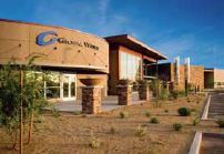 Within Maricopa’s City limits, Global Water has entered into 45 off-site development agreements with property owners requesting potable water service. These agreements allowed for Global Water to masterplan and install regional infrastructure to accommodate the extreme growth Maricopa has experienced, and ultimately will allow for the long term sustainable development of the entire City. In total, SCWC has CC&Ns covering approximately 30 square miles of property within Maricopa’s city limits. In accordance with a regional master plan, Global Water has constructed a substantial potable water system to support this area including transmission and distribution pipelines, well sites, treatment, storage and distribution facilities. Currently, SCWC operates a treatment, storage and distribution facility in Rancho El Dorado in conjunction with a second facility in Rancho Mirage that is equipped to accommodate additional growth for the coming years.
At the end of 2014, approximately 12 square miles of SCWC’s CC&N had been developed to accommodate a customer base of 18,183 potable water accounts for both commercial and residential users.
The City is fortunate to have the vast majority of infrastructure constructed since 2000, utilizing contemporary water conservation technologies, unlike other communities in the region. Most all green spaces and landscaping in the City are watered with reclaimed effluent, greatly reducing the City’s water consumption (refer to H3.b.2 to require purple piping for all new development) while maintaining a lush desert landscape aesthetic. Additionally, new public buildings are utilizing low flow fixtures, City Codes incentivize water conservation for new development, the housing stock is mostly built under contemporary low-flow plumbing codes, and the City instituted a drought tolerant landscape palette that is integrated in most all development in the City.
Promotion of a continuing and escalating water conservation ethic will enhance the future water supply. Conservation is the most economical water savings source for both provider and user, and in some cases can reduce operating and capital costs. Water rates, conservation programs, and community education will be the primary elements to further conservation efforts. The City of Maricopa has a Vision to become the water service provider, giving the City much greater control over future water quality, delivery and costs to the residents. Goals and objectives for water services in Maricopa are provided in the Utility Services section.
b. Waste Water
Palo Verde Utilities Company (PVUC), a subsidiary of Global Water Resources, Inc., provides the only sanitary sewer and wastewater treatment services to the citizens and businesses within Maricopa (excluding a very small customer base that continues to utilize septic tank systems in the Heritage District and Seven Ranches). In accordance with a regional master plan, Global Water has constructed a substantial wastewater collection system to support Maricopa and surrounding areas that includes the necessary gravity and force mains, lift stations and a water reclamation facility (WRF). PVUC operates the WRF with a permitted treatment capacity of 3.0 million gallons per day (3.0 MGD) which is located in Rancho El Dorado. As of year-end 2014, approximately 75% of the facility’s capacity was in use. PVUC has initiated the next phase of expansion to properly accommodate the continued growth within the City, and expects to complete this expansion project in 2017. The WRF campus is sized to ultimately accommodate up to 12.0 MGD. Similar water reclamation facilities are planned to be constructed within the City’s planning area as growth demands.
Growth
Although PVUC is less than half built out within its current CC&N inside the city limits, the utility continues to actively pursue service territory expansions with property owners located outside the current CC&N when they request wastewater service. In addition, Maricopa has a substantial planning area outside of the city limits which includes an additional 190 square miles of potential land for development. Inside this planning area, Global Water has already secured an additional 106 off-site development agreements and an approved CC&N area consisting of 72 square miles, thus making this area ready for successful growth opportunities.
Recycled Water and Conservation
At the WRF, PVUC treats the wastewater and produces Class A+ recycled water, the highest quality for recycled water in Arizona. Currently, about 75% of this recycled water is returned back to the community for irrigation purposes. As required within the off-site development agreements, an extensive purple pipe distribution system has been constructed throughout Maricopa and within most developments (reference Goal H3.b.2 Wastewater Utility). This recycled water distribution system will continue to be extended throughout the City as new development occurs. The direct beneficial use of recycled water on this scale has many benefits to the City including lower demands on the groundwater aquifer while still allowing for the beautification of communities and open spaces. In 2014, a total of 578 million gallons of recycled water was delivered within Maricopa for irrigation purposes, reducing the use of non- renewable groundwater by approximately 30%. Since 2004, PVUC has delivered over 5.2 billion gallons of recycled water for beneficial irrigation uses; successfully achieving a key element of a meaningful conservation program.
PVUC’s 100% Reuse Model
Global Water strives to remain an industry leader in conservation and reclamation, and is close to completing all necessary steps to achieve a 100% reuse model. In order to achieve and maintain a 100% reuse model, all byproducts of the wastewater treatment process must be utilized for a beneficial purpose. There are two main byproducts that are naturally created from the biological treatment process of the wastewater; recycled water and bio-solids.
As previously mentioned, the recycled water is delivered back to the community for beneficial use as non- potable irrigation. During the winter months, the irrigation demands are lower and the incoming sewer flows are higher due to the returning winter citizens, so a surplus of recycled water is created in which PVUC discharges into a local wash, allowing for natural recharge. To achieve full direct beneficial reuse, PVUC is partnering with local businesses to utilize the surplus for agriculture purposes. This is planned to begin late 2015.
The second byproduct of the treatment process created is bio-solids. In 2013, PVUC conducted rigorous testing of its bio-solids byproduct, and determined by state regulations that the byproduct was suitable for agriculture and to fertilize crops grown for non-human consumption. In 2014 PVUC partnered with a local farmer, completed the proper permitting processes, and began delivering all their bio-solids for its beneficial use at local agriculture businesses instead of being taken to a landfill.
This 100% reuse model is an important accomplishment for Maricopa, as beyond the environmental benefits, all the byproducts are going to benefit the local business and farming community.
Maricopa’s residents take comfort knowing they live in a safe community and where citizen involvement supports and upholds the value of safety and security in Maricopa. Maintaining a community in which all residents, businesses and visitors are safe requires the efficient and effective use of public safety resources and active citizen involvement in promoting safety and security in their own neighborhoods and community. There are two primary areas of real and perceived safety this element addresses: neighborhood safety and hazard mitigation and emergency preparedness.
2040 Vision: Maricopa is a safe and livable community in which citizen involvement supports and upholds the value of being safe and secure in one’s own community.
The Safety Element, in conjunction with the goals and policies of the Emergency Services section provide a framework to address the protection of the community from any risks associated with naturally occurring, human induced or national emergencies that could affect the City. Whether extreme climate, flooding, national disasters or even the handling and transportation of industrial chemicals, the City must be prepared to manage these risks through awareness and preparedness by way of adequate planning, staffing, training and infrastructure. This element establishes the framework to ensure the City’s ability to prevent, prepare, respond and recover from all to threats and hazards to the community.
Safe Neighborhoods
People want to feel they are safe when they are walking, biking, or traversing their community. Whether they are commuting to school or work, traveling on streets, or visiting parks and businesses, the community design plays an enormous part in the perception of safety and crime prevention. As a result, the design of a community can hinder or enhance people’s activities and willingness to engage within a community. Land use decisions play an important role in promoting citizen interaction through everyday activities within the neighborhood or community. Equally important is the role that perception can play in creating safe neighborhoods. Design techniques can help minimize perceived safety problems. Such techniques include creating neighborhoods and communities that provide integration and balance of uses; viewing streets as an amenity, requiring front porches and visible open spaces, and other semi-public areas to encourage community observation and interaction. Crime Prevention through Environmental Design (CPTED) and Safescape principles play a vital part in promoting safe neighborhoods with the emphasis on natural surveillance, territorial reinforcement, natural access control, and hardening target areas.
The Emergency Services (Section II. H2.a) section in conjunction with the Neighborhood Preservation Element (Section II. B5) outline a comprehensive community policing policy, from land use and design strategies to coordinated neighborhood resources for effective communication and actions that address potential threats.
Hazard Mitigation and Emergency Preparedness
In recent decades, natural and human-caused disasters have led to increasing levels of death, injury, property damage, and interruption of business and government services across the United States. Not only do disaster events take a toll on families, individuals, businesses, and the area economy, but affected communities must devote significant time, money and effort to respond to and recover from these emergencies or disasters, often diverting public resources and attention from other important programs and problems.
Hazard mitigation planning can be an effective strategy for preventing or significantly reducing the impact of such hazards prior to their occurrence. The mitigation planning process involves identifying and profiling the natural hazards most likely to occur in a community, assessing the vulnerability of citizens and the critical community facilities and structures to these hazards, and establishing goals, actions, and projects that mitigate the associated risks.
Maricopa participates in regional planning for hazard mitigation and emergency preparedness with Pinal County Emergency Management. The Pinal County Emergency Response and Recovery Plan (ERRP) and EPA Pacific Southwest Region 2015 Emergency Prevention and Preparedness Plan Update, provide the framework for Maricopa’s hazard mitigation, preparedness and response program. The City will continue to participate in regional and local planning through preparation and updates to local strategies for Homeland Security and the City’s Emergency Operations Center focusing on an all-hazards response to critical infrastructure, pursuant to Objective H2.a.1.2 of this General Plan. The City’s Public Information Officer (PIO) maintains communications and distributes emergency messages to the community to prepare, during, and after a disaster. The messages are consistent with all agencies providing directions and actions to take during an emergency. Future plans that are developed must have provisions for communications, supplies, healthcare, law enforcement, and disaster relief. In addition, the plans must be revised and updated on a regular basis due to continued growth and development within the planning area.
Maricopa’s remote proximity to other urban areas requires close coordination of emergency response with the Ak-Chin, Gila River, and Pinal County. One of the most likely threats to Maricopa’s safety and loss of property is the likelihood of flood inundation. Priorities for City improvements to mitigate this threat are included throughout this General Plan. Floodplain mitigation solutions (see Sections II. C2 Floodways & Washes and H2.f Flood Control) adequate emergency access (see Objective E2.2.4) and public buildings that can serve as facilities for emergency response are all necessary to support an effective emergency management and response. Telecommunications infrastructure implemented by the MPD (see Section II. H2.a Emergency Services - Police) in conjunction with the regional dispatch system of MFP provides the telecommunications infrastructure to coordinate emergency response with surrounding agencies.
Providing medical response and protection against crime, natural and man-made disasters, fire, and flooding are primary concerns for City emergency services. Safety for both crime and disaster prevention can be increased through land use planning and community design. Hazards are further reduced by continued training, application of Zoning Code, Subdivision Ordinance, Fire and Building Codes, and regional cooperation. For the City of Maricopa the primary concern will be maintaining efficient services by locating new facilities and infrastructure as the community grows. Critical to this effort will be implementing emergency medical services and medical facilities as outlined in Section II. H2.d5 and 6.
Maricopa strives for an integrated, citywide, regional, and multi-modal transportation system that is safe, functional and integrated with smart city practices. The Circulation Element is intended to guide the development of a citywide multi-modal transportation system integrated with, and in support of the land use element. Over the next 20 years, travel in the Maricopa planning area will dramatically increase proportionately with anticipated population growth in the region. In support of sustainable growth and economic development, the City’s circulation system will need to keep pace.
The circulation system is the backbone of the City, supporting the economy and serving and influencing land use patterns in a positive way. Maricopa has grown using the automobile as the primary mode of transportation, as most all cities in the Southwestern United States. The automobile will continue as the primary mode of transportation, but there is an increasing emphasis on alternatives to the personal automobile for transportation, such as public transit, bicycling, and walking. This element is a guide for planning and implementing alternative modes of travel to afford greater accessibility for residents and visitors, mitigate congestion and pollution, and support a more efficient and sustainable land use pattern. Transition to a more complete multi-modal transportation system requires an integrated land use and transportation planning approach. The planned transportation system shall support the City’s vision for a land use pattern with concentrated mixed-use Village Centers and neighborhoods. Transportation access is the heart of a successful mixed-use development pattern, where more intense growth occurs around major roadways and transit facilities.
Sections of this Element:
- Introduction
- Regional Connections & Roadways
- Pedestrian & Bicycle Circulation
- Transit
- Circulation Plan
The City of Maricopa adopted a Transportation Master Plan in 2015 to serve as the long–range transportation plan for the City and greater planning area. The Maricopa Transportation Master Plan is a multi-modal plan for transportation facilities and services and a guide for strategic multi-modal transportation investment decisions over the long term. The plan directly responds to and provides guidance for implementing the 2040 Vision Strategic Plan and is reflected in this General Plan element.
Interactive Maps (GIS)

1. Introduction
In the Maricopa area, the vast majority of all trips are made by automobile and most of this travel is on two State highways, a County highway, and a series of section line roads. The transportation system serving Maricopa is and will continue to be challenged by substantial physical constraints such as major drainage features and the Union Pacific Railroad (UPRR), Indian land, and mountain ranges along the western edge of the planning area. There are also non-physical constraints to developing a regional roadway network. Previously approved planned community zoning applications in Maricopa and the greater planning area precede the regional transportation plans now in existence. In some cases, prior zoning approvals do not adequately address regional transportation needs and/or compatible land uses.
Since the adoption of Maricopa’s first General Plan in 2006, a number of local and regional transportation planning efforts have occurred. The I-8 and I-10 Hidden Valley Transportation Framework Study prepared by MAG through a collaborative effort of local jurisdictions and ADOT, established a plan for future major routes to serve western Pinal County and southwestern Maricopa County. The Hidden Valley Framework Study along with Pinal County’s Small Area Transportation Study (SATS) and Regionally Significant Routes for Safety and Mobility Plan (RSRSM) have provided Maricopa with guidance for establishing future planning corridors for major roadways needed for regional connectivity to support projected growth and travel demand. Additionally, transit studies and regional connectivity plans have occurred and the City has adopted a master trails plan for Maricopa’s planning area. All of these studies were conducted since the 2006 General Plan and provide guidance for future decisions impacting long-term transportation serving Maricopa.
Over the years, the City has undertaken studies to provide guidance on transportation needs and priorities within the incorporated boundaries. The White & Parker Major Investment Study (MIS), 2008 Maricopa Regional Transportation Plan (RTP), the Pinal County East-West Corridor Study, and the Maricopa Area Transportation Plan of 2015 provide findings and recommendations specific to identified areas of need.
Maricopa became a member of the Maricopa Association of Governments (MAG) Municipal Planning Organization in 2012. As a member agency, Maricopa is included with the regional transportation planning and research efforts of the Phoenix metropolitan area, among other benefits. The Maricopa Area Transportation Plan builds upon MAG projection data and prior transportation studies to establish short, mid, and long-term transportation goals in-line with the citizen’s strategic vision for future land use and transportation. The recommendations are incorporated into this General Plan and are a foundation of this element.
2040 Vision: The citizens of Maricopa desire a carefully planned and well-designed community of quality growth and development. Through the visioning process, the community identified a number of goals and strategies that provide the framework for this General Plan. Transportation is critical to quality growth and accomplishing the desired land use pattern. Maricopa’s citizens have identified the following long-range transportation goals to aid in the fulfillment of their vision:
- Provide greater, more efficient mobility through multi-modal transportation to and from Maricopa
- Create an adequate intra-city road network
- Create transportation connectivity with other cities and regions
- Create Safe and functional pedestrian ways and bicycle routes throughout the City of Maricopa
The preceding discussion organizes these community goals and strategies in a framework to address the transportation needs for Maricopa.
2. Regional Connections & Roadways
From Maricopa, SR-347 provides access to the Phoenix metropolitan area, approximately 20 miles to the north, including access to Interstate 10. Interstate 10 provides highway and freeway links to Mexico and the major cities of Los Angeles, Las Vegas, Tucson and El Paso. The junction of SR-347 and SR-238, and the junction of SR-347 and the Maricopa-Casa Grande Highway occur in Maricopa. To the south of Maricopa, SR-347 connects to the Stanfield area and Interstate 8. Interstate 8 provides access to San Diego and Southern California and SR-347 and SR-238 are important links to San Diego and Puerto Peñasco (Rocky Point), Mexico. To the southeast, Maricopa-Casa Grande Highway parallels the UPRR providing a connection to the City of Casa Grande and central/eastern Pinal County communities.
In a survey performed by MAG and Valley Metro for the Southeast Valley Transit System Study, it was identified that the majority of Maricopa residents travel outside of the City limits for work. A large share of commuters work north of the city with Phoenix, Chandler, Mesa, Tempe, and Gilbert occupying five of the top six work commute destinations in the Phoenix Metropolitan area. Also located east of the City is the City of Florence which the survey results showed as another top work commute destination. The results reflect that public transportation options were not meeting the needs of some Maricopa residents, particularly in regard to express service between Maricopa and the Phoenix Metropolitan Area. Of the respondents, an overwhelming 91% felt public transportation options were lacking. The most common responses for why the public transportation options were lacking were because they do not exist, they do not travel where residents need to go, or they do not travel at the times residents need to travel.
Citizens of Maricopa desire better connectivity to areas outside of Maricopa and the region. The 2040 Vision Transportation, Goal 3, is to create connectivity with other cities and regions, recognizing that transportation routes in and out of the City are essential for increased economic development and regional partnerships. Inter-regional connectivity is critically important to the social and economic welfare of Maricopa and its continued future growth and prosperity, particularly access to the Phoenix metropolitan area and connectivity with proposed east-west routes that would give access to neighboring communities. The Goals and Objectives of the Circulation Element promote connections to these regions through all modes of transportation.
| Goal E2.1: |
Develop an efficient and safe transportation system providing multi-modal connectivity to other cities and regions. |
| Objective E2.1.1: |
Implement the recommendations of the Transportation Master Plan and the supporting Capital Improvement Program. |
| Objective E2.1.2: |
Foster strategic regional transportation partnerships with other jurisdictions and agencies (AMTRAK, ADOT, Pinal County, Gila River Indian Community, Ak-Chin Community, utility providers, Maricopa County, Valley Metro RPTA, Sun Corridor MPO, CAG, and MAG) to plan, design, and construct local and regional transportation improvements. |
| Objective E2.1.3: |
Support all jurisdictions efforts to implement regional roadway improvements that further the objectives of the Transportation Master Plan and Regional Connectivity Plan. |
| Objective E2.1.4: |
Plan for roadway corridors to improve local circulation and regional connections, such as north/south travel routes in addition to SR-347, and high capacity east/west regional travel routes. Implement policies, such as the Transportation Corridor Overlay Zoning District and incentives to encourage compatible land uses along these corridors at appropriate locations. |
| Objective E2.1.5: |
PTOS Master Plan update should incorporate a feasibility study for regional equestrian trail plan and facilities with connections to adjacent jurisdictions. |
Roadway Network
In 2016, the City of Maricopa owns and maintains all roadways, except State routes (SR-347 & SR-238), within the incorporated boundaries. Pinal County administers all non-State route roadways in the unincorporated portions of the Maricopa planning area.
The primary roadway within Maricopa is SR-347, a four-lane (with short segments of five and six-lanes), ADOT-maintained facility, which traverses the community in a north-south alignment. The other major roads are primarily two-lane and include the Maricopa-Casa Grande Highway and SR-238.
The roadways providing primary east-west access include Smith-Enke, Honeycutt, Bowlin, Farrell and Peters and Nall. Additional north-south access is provided by Green, Porter, White and Parker, Murphy and Anderson Roads.
An extensive grid of paved and unpaved, section-line roadways provide access throughout the unincorporated portions of the planning area. At the southern edge of the planning area, the paved east-west routes of SR-84 and Interstate 8 provide a relatively high level of service.
The City has made significant strides to improve the existing arterial roadways since the adoption of the 2006 General Plan. One of the more impactful accomplishments is the planning and identification of funding for the SR-347 grade separated crossing at the UPRR intersection. While still in the planning process, this effort will create a much safer and efficient roadway for the primary artery of the City. The draft environmental assessment suggests that in the long-term, improved traffic flow through the area would benefit local businesses, as people could more conveniently frequent local shops and services with less congestion and delays from the current 50-plus daily train crossings. This improvement will also enhance access to properties in the growth area along SR-347 south of the tracks, making the area more attractive for development and redevelopment.
In addition to the strategy to complete the SR-347 grade separation/overpass of the UPRR, Maricopa citizens also desire an adequate intra-city road network (2040 Vision Transportation, Goal 2) that includes safe and functional pedestrian ways and bicycle routes throughout Maricopa. To further this endeavor, the Transportation Master Plan recommend the City adopt a “Complete Streets” policy which is a modern planning approach to roadways that considers all modes of transportation equally and safely to make it easy for pedestrians to cross a street, walk to shops, bicycle to work and school, or access transit service. The Complete Streets concept is intended to provide safe and effective access to transportation for people of all ages, physical ability, or mode of transportation. Making the community safe to walk and bicycle has the notable potential to foster improved health, encourage community interaction, promote sustainability and demonstrate environmental stewardship. Safe bicycle and pedestrian routes are more specifically discussed in the Pedestrian and Bicycle Circulation section of this element.
| Goal E2.2: |
Develop an efficient and safe intra-city road network, including a hierarchy of roadways, which meets the long-term vision of the citizens. |
| Objective E2.2.1: |
Fully implement the recommendations of the Transportation Master Plan (and subsequent adopted transportation related plans) on roadways within the City, including the adoption and implementation of a Complete Streets policy and associated roadway and infrastructure standards. |
| Objective E2.2.2: |
Establish truck routes through Maricopa and near adjacent farms. |
| Objective E2.2.3: |
Incorporate the SR-347 grade separation project in the 2016-2021 CIP and complete the overpass. Update the Redevelopment Area Plan to account for planned roadway redesign and parcel configurations impacted by the proposed roadway alignments to best leverage the economic and public benefits. |
| Objective E2.2.4: |
Identify a CIP to improve major rail-crossings and deficient roadway intersections in the designated growth areas. Improve secondary public safety access to all existing developed residential areas. |
| Objective E2.2.5: |
Accept control of all roadways within Maricopa currently under the jurisdiction of other agencies. |
| Objective E2.2.6: |
Integrate monitoring and traffic flow control infrastructure to all signalized arterial intersections (Intelligent Traffic Systems (ITS)). |
| Objective E2.2.7: |
Design, improve, and maintain existing and new transportation facilities within the Growth Areas in accordance with adopted codes, safety standards, and design details including landscaping and aesthetic standards. |
| Objective E2.2.8: |
Implement Transportation Corridor Overlay Zoning and Gateway locations in accordance with Land Use Goals. |
| Goal E2.3: |
Ensure fair and adequate financing to meet transportation needs. |
| Objective E2.3.1: |
Pursue dedicated funding sources, assistance from other levels of government and maintain updated impact fees associated with new developments. |
| Objective E2.3.2: |
Join with other jurisdictions and communities to seek increased state, regional, and federal sources of funding. |
| Objective E2.3.3: |
Assess and regularly update development impact fees for transportation improvements. |
Functional Classifications & Facility Types
The primary roadways in the Maricopa Planning Area are functionally classified and categorized as to facility type within the Transportation Master Plan. The designations of Parkway, Principal Arterial I and II, Minor Arterial, Collector, Village Collector, 60’ ROW Collector, and Local roads are described in detail in the Transportation Master Plan. These designations are unchanged by this General Plan.
Arterials are described as four to six lanes, moderate speed facilities, generally located on a one-mile grid, serving major traffic within Maricopa. Two levels are identified, the first has a high level of access control to support large traffic volumes and connections to the regional system, and the second has more access points and local service. Examples of principal arterials include SR-347, Honeycutt Road and Maricopa-Casa Grande Highway. Examples of Minor arterials include Smith-Enke and Steen Roads.
Collector streets are two lanes in width, lower-speed facilities, often located midway between arterials. Collectors provide internal circulation and connect local roads within neighborhoods to the arterial roadway system. Land use patterns should permit higher intensity uses and mixed-use along arterial corridors and lower intensity uses such as single-family homes on local roads.
3. Pedestrian & Bicycle Circulation
There is a limited system of pedestrian and bicycle facilities in the City of Maricopa. Bicycle traffic currently uses the street system, outside of the open space paths developed internal to residential master plans. Of particular concern is the need for safe pedestrian crossings given increasing traffic volumes. Limited or no sidewalks exist in the Heritage District Redevelopment Area and along SR-347, SR-238, and Maricopa-Casa Grande Highway to serve pedestrians.
There is no known trail or unpaved pathway system within the City. Most trails in current development do not provide connectivity to community destinations or between neighborhoods and developments.
The City’s Community Services Department has established designations and standards for paved and unpaved pathways and trail systems in the Parks, Trails and Open Space Master Plan (PTOS). The Complete Streets Network as part of the Transportation Master Plan, and included herein, expands upon the existing master Trails Plan of the PTOS for pedestrian and bicycle mobility. Additional information is found in the Parks, Recreation and Open Space Element of this General Plan.
The importance of alternative modes of travel for the City, namely bicycles and pedestrians, is documented in adopted City policies: City of Maricopa General Plan 2006, 2008 PTOS, City of Maricopa 2040 Vision Strategic Plan, and the Transportation Master Plan. Generally speaking, increasing accessibility and mobility of these groups of a community’s citizens increases the accessibility and mobility for all travelers. This understanding is further explained in the Transportation Master Plan.
Connecting bicycle facilities on local and collector streets to local services and destinations increases the likelihood of convenient short trips. Direct connections from local and collector streets to off-street shared use trails/paths also would be supportive of safer bicycle travel by bypassing arterial streets. Connectivity at the neighborhood level enables people to take shorter routes and travel on quieter streets, which is more conducive to bicycling. A complementary “Wayfinding” program would provide support for navigating the network of bicycle facilities on local and collector streets. Wayfinding is modern jargon for knowing where one is located, where one desires to go, and having the information on how to get there.
The City of Maricopa 2040 Vision identifies six areas of strategic importance to the community that must be addressed to achieve the overall vision for the community and improve quality of life for its citizens. Within the context of these strategic areas, there are several goals and strategies that relate to pedestrian and bicycle travel.
“The US Department of Transportation (USDOT) findings regarding bicyclists and pedestrian travel as a transportation mode indicates younger people, in particular (specifically, Millenials) are not as engaged in driving as previous generations. This trend is characterized by fewer miles driven, longer time before applying for drivers licenses, and more frequent use of public transportation, where available. In addition, younger persons rely more on ridesharing and, this more technologically savvy generation, is taking advantage of the taxi mobile applications to reduce reliance on personally-owned vehicles”
-Transportation Master Plan
| Goal E3.1: |
Create safe and functional pedestrian ways and bicycle routes as an alternate mode of travel throughout Maricopa. |
| Objective E3.1.1: |
Fully implement the recommendations of the Transportation Master Plan (and subsequent adopted bicycle and pedestrian related plans (Safe Routes to Schools Master Plan)) on roadways and paths within the City, including the adoption of a Complete Streets policy and roadway standards. |
| Objective E3.1.2: |
Develop a bicycle and pedestrian master plan and wayfinding plan as an element of the PTOS Master Plan update to further analyze trail connectivity and create a strategy for improving a continuous bikeway network. The PTOS Master Plan update shall incorporate best practices for handicap accessibility and feasibility for a bicycle sharing program pursuant to the Transportation Master Plan. |
| Objective E3.1.3: |
Update the existing PTOS Master Trails Plan for the City and update the Trails CIP to develop pedestrian trails and bikeways connecting all development, parks, greenways, and commercial areas within the City. Incorporate the findings and recommendations of the Trails and Pathways Element of the Transportation Master Plan. |
| Objective E3.1.4: |
Coordinate efforts with GRIC to develop a designated and improved bicycle path along SR-347 north of Maricopa. |
| Objective E3.1.5: |
Update City codes and standards to create a bicycle friendly community and mitigate the physical and psychological barriers to bicycling. All new construction site improvements should include completion of sidewalk networks serving the site, both on and off-site, where found reasonable to complete connectivity. |
| Objective E3.1.6: |
Implement MAG “Toolkit” for pedestrian and bicycle improvement recommendations for improvements to address common transit system access issues characteristic of the hot, arid climate. Consider implementing a “Walk-ability” rating or metrics program to evaluate pedestrian access and comfort of sidewalks, trails, and gathering areas throughout the community. |
| Objective E3.1.7: |
Objective E3.1.7: Work with ADOT to improve pedestrian safety along and across SR-347. |
4. Transit
Maricopa’s citizens have a vision for an integrated, city-wide and regional multi-modal transportation system that provides more efficient mobility to support a more sustainable and desirable land use pattern. The 2006 General Plan recognized growth within the City would require alternative transportation options, particularly to reduce the rate of traffic growth along SR-347. The prior Plan guides the City to work closely with our neighboring communities to expand transit options.
The City has expanded the available public transportation options by way of a limited bus system. Maricopa’s COMET bus transit system provides dial-a-ride service to residents locally, and a limited fixed route service. This bus system also affords residents weekly opportunities for travel to regional health care facilities in two separate regions. Both shuttles provide connections with other transit services at these two regional destinations. Also, the Valley Metro vanpool program provides multiple daily commuter services using the City’s park-n-ride facility as the pick-up and drop-off point with direct connections to locations in the Phoenix metropolitan area.
These public transit services enhance the mobility and connectivity of City residents. The use of public transit affords more productive time for riders, encourages social interaction, and provides localized and regional air quality benefits by reducing the number of personal automobiles, particularly during congested travel periods. As the City and Planning Area grows, it becomes increasingly important to have an efficient and effective public transit system in place to mitigate the resulting increased traffic congestion and carbon emissions. Added attention should be given to expanding local transit options and improving regional transit connectivity to expand the socio-economic opportunities for Maricopa’s diverse population.
The Transportation Master Plan outlines a number of existing transit studies incorporating Maricopa within regional systems. The findings and recommendations of the 2011 Pinal County Transit Feasibility Study and the 2015 Southeast Valley Transit System Study provide guidance for future transit decisions. The Southeast Valley Transit System Study incorporates information from the former study and recommends the optimization of existing bus services. In addition, the Transportation Master Plan provides a short term framework of actions for improving transit services in the next five years. Beyond that the Southeast Valley Transit System Study has resulted in recommendations for the Mid Term Planning Horizon for implementation within 15 years and Long Term Planning Horizon for implementation beyond 15 years.
The 2011 Pinal County Transit Feasibility Study envisions a Maricopa Transportation Center that ultimately would be a focal point for regional transit services offered in Pinal County (between Maricopa and Florence, and potentially to San Tan Valley) and Express Bus connections with destinations in the Phoenix metropolitan area. The City is in the planning stages of a potential Maricopa Transportation Center to possibly be developed in conjunction with the relocation of the Amtrak Station one mile west of the location at SR-347. The function of the Maricopa Transportation Center and other near-term transit investment should focus on implementing the Express Bus, and possibly BRT service to the SR-347 vicinity as an interim solution for commuter travel.
| Goal E4.1: |
Create greater, more efficient mobility through a multi-modal circulation system, including transit, to, from, and within Maricopa. |
| Objective E4.1.1: |
Adopt and implement a CIP to establish Maricopa as a Transit Ready Community. Identify high volume transit service and mobility corridors as opportunities to stimulate and support commercial and employment. Map the Transit Oriented Development Overlay District on the Official Zoning Map for the planned Maricopa Transportation Center area and identified corridors to encourage compatible and supportive land uses. Establish and implement a bus stop policy & standard details in the short term. |
| Objective E4.1.2: |
Establish greater connectivity with the Phoenix metro area by expanding Park-n-Ride facilities and express bus routes to Maricopa. The Maricopa Transportation Center and other near-term transit investment should focus on implementing the Express Bus, or potentially BRT, service along SR-347 as an appropriate interim solution for commuter travel. |
| Objective E4.1.3: |
Optimize and expand the current use of existing buses, shuttles, or trolley within the City to key locations and population centers. Consider facilities for all ages and abilities, including Federal Transit Administration Section 5310 program funding. |
| Objective E4.1.4: |
Conduct or participate in a needs assessment for LRT, Commuter Rail, Intercity/Interstate Rail, Intercity Bus, Bus Rapid Transit (BRT), Express Bus, Local Bus, Feeder Bus, circulators, and demand response. |
| Objective E4.1.5: |
Utilize the findings and recommendations of the 2011 Pinal County Transit Feasibility Study and the 2015 Southeast Valley Transit System Study through MAG and Valley Metro to further develop a framework for a regional transit system and programs. |
| Objective E4.1.6: |
Implement the findings and recommendations of the Transportation Master Plan and subsequent adopted transit related plans. |
Rail Service
The Union Pacific Railroad (UPRR) generally parallels the Maricopa-Casa Grande Highway and SR-238 from Casa Grande to Gila Bend. The rail line through Maricopa was originally constructed in 1879. A significant portion of service along this track through the City was diverted, when rail service was routed on a new line through Phoenix. A portion of the Phoenix route, which linked the Phoenix Subdivision in western Phoenix to the community of Wellton and City of Yuma in western Arizona, was referred to as the “Wellton Branch.” The Wellton Branch was severely damaged in 1995, and the current operator – UPRR, has determined the damage to be too great of a cost to repair. As a result, today, all transcontinental UPRR rail freight traffic and Amtrak passenger service operates on the original line through Maricopa. This rail route traverses the southern part of the United States and connects Los Angeles with Tucson, El Paso, Houston, and New Orleans. It is Arizona’s second busiest rail line.
Currently, approximately 50 freight trains operate daily through Maricopa. Many of these trains are over a mile long. The UPRR recently completed construction and double tracked the existing rail line to accommodate expected growth in rail traffic that may reach 100 trains per day in the future. Union Pacific is experiencing significant growth in the volume of rail freight carried. Due to the current configuration of trackage, all freight trains traveling from Los Angeles to Phoenix pass through Maricopa.Rail-highway crossings pose a particular challenge in Maricopa as the community is bisected by the UPRR line. Rapidly growing communities like Maricopa need a sufficient number of rail-highway crossings that are safe and convenient to support travel demand, commerce and needed emergency service responders. Of particular concern in Maricopa is the SR-347 rail crossing. Delays and safety concerns exist at this crossing where traffic backups have far reaching impacts on traffic operations in the City. A grade separation project (overpass) is underway to separate SR-347 and UPRR.
The Amtrak station is one of eight in AZ, and the closest and most accessible to the Phoenix Metro area. Amtrak’s Texas Eagle (Los Angeles – Chicago) and Sunset Limited (Los Angeles – New Orleans) has scheduled stops in Maricopa. The Station located immediately east of SR-347 at its crossing of the rail alignment, has been hindered by a short station platform. The station design causes 30 minute traffic delays at the intersection of SR-347 and UPRR. The City is in the planning stages of the Maricopa Transportation Center to possibly be developed in conjunction with relocation of the Amtrak Station one mile west of its historic location on the eastside of SR-347. Moving the Amtrak station as part of the Maricopa Transportation Center will remove the cause of delays associated with passenger service and make access to the station more convenient and safer. This improvement also offers a unique opportunity for Transit Oriented Development in the future, and should be planned accordingly. The Redevelopment Area Plan offers strategic goals and objectives supporting this development concept in the Heritage District Redevelopment Area.
MAG’s Commuter Rail Strategic Plan, referenced in the Pinal County Transit Feasibility Study, identifies the SR-347 corridor as a possible rail extension, connecting a future Tempe Branch with the UPRR Sunset Line. Commuter Rail service is in the very early stages of conceptualization and planning. ADOT envisions the City of Maricopa entering into a regional organizational structure that offers a broad range of transit services, which would include studying feasibility of potential future Commuter Rail options. The SR-347 corridor would be a prime candidate for modern rail service connecting with the Phoenix metropolitan area. Refer to Section II F. Economic Development for additional heavy-rail related discussion.
| Goal E4.2: |
Maintain and expand local passenger and freight rail service in Maricopa to create opportunities for economic development, tourism and regional transit. |
| Objective E4.2.1: |
Support continued Amtrak passenger service in Maricopa and remove barriers to expanded usage, ie, secured parking, hospitality, targeted local activities for passengers, etc. Explore opportunities to promote Maricopa as a national destination for tourism and convenient connections to Phoenix metropolitan area. |
| Objective E4.2.2: |
Plan, design, and improve heavy rail track spurs to promote industrial development and warehousing within Maricopa. |
| Objective E4.2.3: |
Study the feasibility of establishing commuter rail service between Maricopa, greater Phoenix and Casa Grande. |
Air Service
With regard to air service, Maricopa will continue to rely on facilities in the Phoenix metropolitan area as the primary providers of service to local residents, visitors and businesses. In 2007 the City completed an Airport Feasibility and Site Selection Study that has yet to be implemented. An update to the study should be pursued based on current and future projected fiscal conditions of the City. The study should further explore the possibility of operating its own general aviation airport or partnering with an existing airport within the Maricopa planning area. A detailed study is recommended to analyze the cost and benefit of both options.
General aviation includes every type of civil flying other than the certified air carriers. Nationally, general aviation accounts for 96 percent of all hours flown and provides access to more than 12,000 communities, while commercial air carriers provide service to about 350 airports. In Arizona, commercial carriers provide service to 20 communities and general aviation public use airports provide access to 100 communities. The estimated increase for Arizona in general aviation aircraft is for at least 40 percent over the next 20 years. In terms of aircraft operations, the landings and takeoffs are expected to increase by at least 64 percent over this same period. This will result in greater demand and need for improvement and expansion of airfield facilities.
The original 2007 airport feasibility study suggests an airport in Maricopa should be geared to corporate use, pilot training, and recreational flying. An important concern arose from the study: residential growth is rapidly absorbing undeveloped land available for an airport. It also recommended the City reserve 600 to 700 acres of land to accommodate the new airport. Pursuant to the findings and conclusions of the 2007 airport feasibility study, in February 2008, the Maricopa City Council approved the preferred site for a regional airport, which currently is known as Estrella Sailport.
There is adequate lead time to permit careful planning for an airport facility and preclude development of sensitive land uses (e.g., homes) near the airport that will be negatively affected by residual noise from airplanes. With the completion of subsequent studies and a decision to move forward with development of the airport, a Site Master Plan would be developed, including environmental studies and all necessary documents to request funds through the Federal Aviation Administration (FAA) and ADOT Aeronautics.
Beyond the possibility of a new Maricopa Airport, the existing Ak-Chin Regional Airport is a publicly owned public use airport located in the east central portion of Maricopa’s planning area, just eight miles east southeast of downtown Maricopa. The airport is owned and operated under the authority of the Ak Chin Indian Community, a recognized public entity. Refer to Section II F. Economic Development for additional airport related discussion.
| Goal E4.3: |
Explore opportunities to establish regular air freight and passenger service through a partnership and/or sole operation of airport facilities within the Planning Area. |
| Objective E4.3.1: |
Prepare an updated airport feasibility study that presents the potential benefits, financial viability and realistic means necessary to establish a partnership or operate a regional airport within the Maricopa planning area. |
| Objective E4.3.1: |
Identify air service opportunities and improvements for the Maricopa area that tie into and support local economic development efforts. |
5. Circulation Plan
Future circulation patterns and roadway volumes are tied closely to patterns of future land use and development. As illustrated in the Land Use Element, future growth and development of the City is geared toward concentrated mixed-use Village Centers at key locations along major transportation corridors. The future circulation system and multi-modal transportation programs are critical to achieving this development pattern.
The Circulation Plan graphically depicts the existing highway and road network serving Maricopa. Major improvements to existing facilities and the development of new roadways and trails are anticipated over the next 20 years. Improvements to SR-347, including additional capacity, and a railroad overpass, are chief among circulation needs. In addition to SR-347, White and Parker and Anderson Roads are identified as major north-south corridors in the City. Smith-Enke, Honeycutt, Bowlin and Peters and Nall Roads are planned as east-west arterials as well.
Specific policies, time frames and responsibilities for positive actions to achieve the Goals, Objectives and Recommendations of the Circulation & Connectivity Element are to be included in the City’s strategic plan.
The Economic Development Element provides guidance and direction for planning to establish a fully integrated municipal economy providing opportunity for residents to live, work and play. The citizens of Maricopa envision an economically prosperous, dynamic and sustainable community. One that offers a government structure that is welcoming and supportive of business and employment growth. Since incorporation, this vision has been one of the City’s initial goals in an effort to ensure Maricopa is more than yet another bedroom community in Arizona. Jobs, revenue and financial stability contribute to a municipality’s economic health. The Economic Development Element seeks to promote these attributes by planning for increased household incomes, improving the community’s jobs-to-housing balance, and by attracting expanded retail, commercial and industrial business within the City of Maricopa’s target sectors, as updated from time to time in the Strategic Plan for Economic Development.
2040 Vision: Maricopa is an economically prosperous, dynamic and sustainable community. It offers a government structure that is welcoming and supportive of business and employment growth. Members of the Maricopa Community at all levels embrace a shared vision, seeking opportunities to establish collaborative relationships with business, educational, neighboring and regional entities for their mutual benefit and advancing common economic development goals.
Sections of this Element:
- Introduction
- Assets & Advantages
- Economic Challenges
- Employment Centers & Corridors
Maricopa is a growing community that offers residents and businesses the experience of a small-town, rural atmosphere, tremendous quality of life, proximity to Phoenix and Tucson, and convenient access to major markets throughout the Southwest. To remain economically healthy over time, the City must recruit, retain and nurture the growth of a wide range of sustainable and competitive businesses.
Historically an agricultural community, Maricopa is emerging as a regional hotbed for the agritech industry. Maricopa is home to a thriving cluster of local agritech businesses and research facilities, including USDA Arid-Land Agricultural Research Center and the University of Arizona Maricopa Agricultural Center. Researchers at these centers are working to develop new technologies and solutions to problems faced by crop consumers and producers. Additionally, leaders in the renewable energy arena have also been drawn to Maricopa. Pinal Energy opened Arizona’s first ethanol plant in Maricopa and the City boasts one of the highest applications of residential solar per capita.
In the automotive industry, Maricopa is helping to pave the way in vehicle research and development. Volkswagen located their North American proving grounds in Maricopa, where they put vehicles to the test under extreme heat, particulates, and solar conditions. Nissan’s proving grounds are located within the planning area.
The General Plan recognizes the importance of retaining local business and fostering expansion. The community is under-served in most every industry group and currently experiences over $280,000,000 in retail leakage. The 2014 Maricopa Citizen Attitude Survey (performed by Raymond Turco & Associates) identifies that the lack of retail/industry was far and away the most frequent response as to the most important issue facing Maricopa. Lack of jobs/economy scored second of the most critical issues facing Maricopa.
The City has many assets to build upon and has focused on both recruitment of new businesses and also providing support and resources to existing businesses. As part of a focused effort to assist small business in the community, Economic Development staff participates in an outreach program to visit local small businesses to identify assistance needs, and share valuable resources and tools. Additionally, the Shop Local program is a multi-year initiative to stem retail leakage by raising awareness of the many benefits of shopping locally and encouraging residents to think of Maricopa first. The campaign is strategically timed to ramp up during the peak shopping seasons. This and a number of other programs are underway.
1. Introduction
Since incorporation, a number of exciting projects have been completed in Maricopa to better position the City to attract new business and employers. The opening of Central Arizona College’s Maricopa Campus, Banner Health Medical Center, a new City Hall and Police Administration building, and the Copper Sky Multigenerational/Aquatics Center and 98-acre Copper Sky Regional Park - a destination for sports, fitness, recreation and leisure activities in Maricopa. It also hosts regional athletic tournaments and community events, including the Salsa Festival, Merry Copa, Science City, Fishing Derby, Great American BBQ and Stagecoach Days. With a projected 500,000 visitors in its first year, it has become the center of activity in Maricopa. Copper Sky will also be a catalyst for economic development. To leverage the regional attractions at the complex and further the goals of the City, 18 acres of highway frontage has been reserved for future commercial and hospitality development. The vision is to transform the property into a high-quality mixed-use destination that compliments the Copper Sky Recreation Complex and delivers significant social and economic impact on the community.
The citizens of Maricopa desire a diverse and sustainable economy through the creation and maintenance of programs and services which expand tourism. Economic Development resources should be devoted to assisting the update of the PTOS Master Plan to align efforts with the Community Services Department. More specifically, to develop and implement strategies to expand tourism through recreation destinations and sporting events with regional and national interest as identified for Goal Objective G2.1.7.
Employment & Business Development Resources
The City has established Maricopa Economic Development Alliance (MEDA), a public-private partnership that supports the economic development efforts of the City. MEDA focuses on bringing together the business, government, education, and civic sectors to identify and advance forward-looking policies that facilitate investment, growth and workforce development. Another important resource established by the City is the Maricopa Center for Entrepreneurship (MCE), which is a local business incubator organization dedicated to assisting small businesses grow. These are accomplishments stemming from recommendations of the 2006 General Plan. MEDA and MCE will be instrumental in providing resources to accomplish many of the Economic Development Element goals and objectives.
The City engages other resources that are also instrumental in meeting the educational, training, and employment goals of the 2040 Vision and General Plan. Arizona Workforce Connection, a statewide system of workforce development partners, and Central Arizona College have partnered to create a one-stop center that provides a range of free services for Pinal County employers seeking access to skilled new hires or existing worker training resources.
Arizona Apprenticeship is a voluntary, industry-driven system of on-the-job training and related technical instruction, approved by the State of Arizona, sponsored by employers, employer associations, and jointly by management and labor.
| Goal F1.1: |
Cultivate a climate of rich educational opportunities at all levels which support economic growth (refer to Schools for additional goals and objectives) |
| Objective F1.1.1: |
Partner with education institutions at all levels to develop competency-based academic programs tied to current and projected industry needs. |
| Objective F1.1.2: |
Prioritize recruitment of companies with incentivized training and education programs for their workforce. |
| Objective F1.1.3: |
Provide training that connects available retiree and senior workforce and skill sets with existing needs in the community. |
| Goal F1.2: |
Provide responsive and high-quality services and process support for businesses at all stages of growth |
| Objective F1.2.1: |
Enhance direct business support and training services through organizations such as small business development centers, chambers of commerce, and business incubators. |
| Objective F1.2.2: |
Solicit direct involvement of the business community in defining the language and intent of new rules and regulations. |
| Objective F1.2.3: |
Establish digital resource pages dedicated to issues affecting the startup of a business such as potential lending sources, how to write a business plan, what to do as the business expands or contracts, and where to look for business growth opportunities. |
| Objective F1.2.4: |
Develop programs that educate business owners and entrepreneurs on the basic components of operating a business, how to plan for growth, and how to structure a new or restructure an existing company. |
| Objective F1.2.5: |
Raise awareness of business assistance services offered by economic development organizations and government offices that work with businesses. |
| Objective F1.2.6: |
Establish a comprehensive resource center providing vocational counseling, job-readiness and placement assistance services that connect employers to a well-prepared labor force. |
| Objective F1.2.7: |
Proactively look to other communities and economic development organizations for best practices in business support programs and services. |
| Objective F1.2.8: |
Engage with the business community to identify shared concerns. |
| Objective F1.2.9: |
Streamline and simplify governmental permitting processes to assist businesses in locating or expanding within the community. |
| Objective F1.2.10: |
Develop a report or analysis of existing businesses, their growth potential, their current and anticipated needs and how they can be promoted for future growth. |
| Objective F1.2.11: |
Use local and statewide economic development agencies and tools to make the City a more competitive business location, to encourage private sector investment to create new jobs and expand the local tax base. |
2. Assets and Advantages
The discussion below reviews Maricopa’s assets and ties these assets to specific areas of comparative advantage.
Whereas definitive data is hard to come by, and conditions are changing due to growth and an aging population, data and estimates from Census 2010 and the City of Maricopa 2013 Labor Survey allow for general comparisons. It should be noted that current data is not available, the figures included herein represent a ‘snapshot’ in recent history, and that steady growth has produced changes in the workforce, with particular emphasis on growth in the construction and retail sectors.
The labor study again identifies that the City of Maricopa has a highly educated and skilled workforce. This beneficial attribute will prove to be a positive economic development asset.
Nearly 80% of employed residents work outside of Maricopa, though residents desire to work closer to home or within the community. This is a great strength Maricopa offers to attract new business and should be leveraged in recruiting efforts. Additionally, Maricopa has an exceptionally educated workforce with incomes well above average. A Labor Survey was performed in 2013 and found the following competitive advantages:
- Compared to the Greater Phoenix region, Maricopa has a relatively large percentage of residents in high wage jobs, earning between $50,000 and $100,000.
- Maricopa has a relatively abundant concentration of residents with either a bachelor’s or graduate level degree.
- Most residents own homes which facilitates workforce stability.
- Maricopa residents currently work in a variety of industries, but when compared to the Greater Phoenix region relatively more work within higher value added (i.e. higher wage) industries such as manufacturing, finance and insurance, and medical professions. The community also has a relatively high concentration of engineers.
- The above average workforce also commutes a longer distance to work. Many would prefer to be closer to home as new business development occurs. 85% of those not already working in Maricopa would take a similar job closer to home. 44% would change careers.
- 97% favor employer recruitment.
Household Income
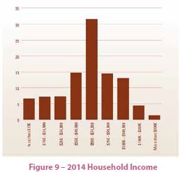 Income and years of education are prime proxies to gauge skill level. Maricopa has a relatively large percentage of residents in high wage jobs (earning between $50,000 and $100,000) compared to the greater Phoenix area. As of 2014, the median household income was $58,338.
| Goal F2.1: |
Recruit high performing and high quality companies that match the labor profile in the community and / or complement existing industries. |
| Objective F2.1.1: |
Ensure all future development infrastructures include fiber-optic and other desirable telecommunication facilities and utilities. |
| Objective F2.1.2: |
Partner with local Nissan and Volkswagen leadership to identify opportunities for, and recruit ancillary and complementary businesses, technology, and research and development firms to build upon the existing automotive industry in Maricopa. |
| Objective F2.1.3: |
Leverage existing uses and industries to pursue agritech and alternative energy related businesses to expand the “clean and green” portfolio within the City. |
| Objective F2.1.4: |
Undertake a detailed employment study to more specifically identify existing resident’s occupations, education, and skill sets to develop a strategically targeted business recruitment campaign. |
| Objective F2.1.5: |
Recruit services and industries that fill a gap in local business offerings and support other business activity. |
| Objective F2.1.6: |
Create and maintain a business attraction and expansion marketing program promoting the business climate of Maricopa. |
| Objective F2.1.7: |
Use local and statewide economic development agencies and tools to make the City a more competitive business location, to encourage private sector investment to create new jobs and expand the local tax base. |
Labor Force
Maricopa offers employers access to a talented local workforce with a larger than average workforce-aged population. Maricopa’s labor pool is both young (average age of 31.2) and educated, with 46% holding a bachelor’s degree or advanced degree, and an astounding 89% having at least some college education.
Residents of Maricopa are employed in a wide distribution of industries represented with manufacturing, retail, finance / professional services, education, and medical / healthcare each having at least 10% of the employed residents. Most of these industries equate to higher wages for employees. Conversely, there is very little reported employment within categories such as restaurant/hospitality which has relatively low wages. Compared to the metro Phoenix as a whole, Maricopa has a higher percentage of manufacturing employment but a lower percentage of professional services.

Figure 10 – Employment Commute Statistics (Graph 1)
Location Advantages
Maricopa’s proximity to the Phoenix metropolitan area produced a major residential growth spurt driving substantial population growth and associated growth in demand for consumer goods. SR-347 provides critical access to Maricopa from the Phoenix metropolitan area, serving as an “economic conduit” for the community. Maricopa serves as an intervening opportunity for almost all traffic to or from Harrah’s Ak-Chin Casino and Ultra Star Multi-tainment Center.
Ground
Located between Phoenix and Tucson, Maricopa offers convenient access to major markets throughout the Southwest. Interstate 10, the southernmost coast-to-coast highway in the United States, is just 15 minutes from Maricopa along SR- 347 and directly connects to Phoenix, Tucson, and Los Angeles. Interstate 8, immediately south of Maricopa, runs west to San Diego and merges with Interstate 10 to the east. Maricopa is also centrally located along SR-238 and Maricopa-Casa Grande Highway which provides east-west connections to Gila Bend and Casa Grande through Maricopa’s central business corridor.
According to the CAG RTP, Pinal County is strategically positioned to take advantage of the emphasis on the Sun Corridor, and northwest of Casa Grande (Maricopa) has been determined potentially viable as a warehousing mixing center. Potential I-11 through Maricopa’s planning area would enhance this opportunity for truck freight services and other trucking related facilities (e.g., servicing facilities, distributions warehouses, etc.)
Rail
Between 45 and 55 freight trains operate daily through Maricopa along the Union Pacific Railroad’s Sunset Route. This route carries nearly 20% of Union Pacific’s total freight traffic and stretches from Los Angeles to El Paso. In Maricopa, the route parallels the Maricopa-Casa Grande Highway and there are many available commercial and industrial zoned sites with potential for rail-to-site. See Section II E. Circulation & Connectivity E4.2.2 for additional goals and objectives.
Maricopa also offers passenger rail access and is the greater Phoenix area’s Amtrak hub. Amtrak’s Orlando-Los Angeles Sunset Limited has a scheduled stop in Maricopa, the only stop in the Phoenix metropolitan area. Refer to Goal E4.2 of the Circulation & Connectivity Element for heavy rail transportation strategies.
Air
Maricopa is just 32 miles from Phoenix Sky Harbor International Airport, one of the 10 busiest airports in the United States. More than 100,000 passengers, 1,200 aircraft, and 800 tons of cargo pass through Sky Harbor each day. The airport is served by 17 major airlines with daily service to 80 domestic and 20 international destinations. Locally, the City is conveniently served by two smaller airports. The Ak-Chin Regional Airport is a publicly-owned public-use airport located in the eastern most portion of the City of Maricopa planning area, and directly abuts the City’s incorporated boundary. The airport site also is home to a number of local manufacturing and aviation related businesses and provides a local source for employment and commerce, though currently outside of corporate limits.
The second local airport is the Estrella Sailport, located in the northeast planning area and also abutting the city’s incorporated boundaries. Estrella Sailport is a privately owned public-use glider airport located seven miles west of Maricopa’s central business district. The airport covers an area of 640 acres and was the recommended site for City operated airport facilities in a 2007 Airport Feasibility and Site Selection Study performed on behalf of the City. Estrella Sailport is home to one of the largest glider training facilities in the United States and provides a unique opportunity for travel and tourism to Maricopa. Refer to Goal E4.3 of the Circulation & Connectivity Element for air transportation strategies.
Other Advantages
Climatic
- Desert climate; mild winters
Natural Environment
- Wide-open spaces, beautiful views, night-sky viewing
- Maintains high-level of environmental quality
Transportation Network
- Situated on SR-347
- Access to interstate highway network (I-10 and I-8)
- Direct access to transcontinental Union Pacific Railroad
- Amtrack Station
Residential
- Low to moderate housing costs, attainable housing
- Small-town ambiance, safety, quality of life
- Easy access to nearby metropolitan goods, services and amenities.
Commercial
- Easy access to Central Arizona labor market
- Easy access to goods and services regionally and nationally
- Low to moderate site and operating costs
- Land available for development; land zoned for Industrial and Commercial use
3. Economic Challenges
All communities and regions have obstacles to overcome and Maricopa is no exception. Some of these challenges are clearly more correctable than others.
Under-Served Population. Some of Maricopa’s biggest needs are for expanded retail services and medical facilities. Presently, residents demand for consumer goods and full-service medical services are met outside Maricopa, thereby economically ‘leaking’ revenues to other communities.
Proximity to Metropolitan Phoenix. This is a double-edged sword. The fact that Maricopa is near Phoenix means that it is in direct competition with Phoenix’s greater commercial sectors. The other edge of the sword being identified as a Phoenix-metro city significantly enhances market credibility.
Under-Utilized Commercial Centers and Corridors. SR-347 provides a central primary business corridor for the City. Significant improvements are in progress to enhance this corridor, both functionally and aesthetically with the funding of the SR-347 Overpass. This overpass along with proper planning of the surrounding land will provide greater connectivity between the Heritage District and Gin Site industrial park, to the anticipated Copper Sky Mixed-use development and larger contiguous commercial parcels of land along 347, south of the railroad tracks. The overpass alone will not ripen these corridor properties for development as they remain in the floodplain and are therefore less advantageous for development.
The City’s Economic Development potential is greatly limited due to a lack of available commercial, office, and industrial space in the commercial corridor. This condition will likely remain until a floodplain solution is implemented for the Vekol tributary. Refer to Section II H2.f Flood Control for additional details.
Work/Residence Separation. The metropolitan Phoenix employment centers drain off local demand for goods and services because of a combination of work commuting and shopping trips. The lack of local industry and retail businesses currently robs Maricopa of a potential tax base. The Goals and Objectives within this element are intended to address this reality to the benefit of the City.
4. Employment Centers & Corridors
Figure 5 Maricopa Growth Area & Employment map identifies lands within the community along the major transportation corridors that are suitable for employment based uses. Many of these sites have necessary industrial zoning to support major manufacturing, office, research and development and similar activities. Both existing employment areas, including the motor vehicle test facilities of Volkswagen and Nissan, and recommended future sites are included. By in-large, the SR-347 corridor offers the greatest opportunity for expanded retail and services in the near-term, based on existing infrastructure and accessibility. Once completed, the planned overpass improvement at the UPRR intersection could accelerate development south of the railroad tracks. Refer to Section II B3. Heritage District Redevelopment Area for additional economic goals and objectives.
">
Public-Private Partnerships
 Maricopa will continue to explore opportunities to engage in public-private partnerships that leverage City and private resources for the purpose of generating a positive economic return (2040 Vision Strategy). The City has proactively engaged in public private partnerships to stimulate economic development through the acquisition of key parcels of land located within the existing Growth Areas and economic corridors. The Gin Site is a planned light industrial and R&D office complex situated in the Redevelopment Area, with convenient access to the SR-238 and SR-347 transportation corridors. The City has contracted with a private firm to develop, operate, and manage the initial phase of this development.
The Gin Site is also designated for a future transportation center adjacent to the UPRR lines, and to include a park-n-ride facility, future transit hub for the region, the only Amtrak stop serving the Phoenix Metro area, and is planned for a rail spur line to support rail oriented industry for the business park. The Gin Site, along with the adjacent Heritage District Redevelopment Area is likely to be the central hub of activity in Maricopa in the coming decade and is planned for transportation, employment, and entertainment related mixed-use and transit oriented development. This area is the first developing urban village core area designated within Maricopa. Refer to Goal E4.1 of the Circulation & Connectivity Element for Transportation Center strategies (Goal B3.1.4).
| Goal F4.1: |
Fast track the development and redevelopment programs for the Estrella Gin Site and the abutting Heritage District Redevelopment Area to create available commercial space and shovel ready sites |
| Objective F4.1.1: |
Plan and entitle (Zone and plat) the Estrella Gin Site business park land to market as shovel ready industrial sites for public/private development. |
| Objective F4.1.2: |
Remove the Estrella Gin Site and the Heritage District Redevelopment Area from the 100-Year Floodplain |
| Objective F4.1.3: |
Update the Redevelopment Area Plan (RDA) to ensure effective urban design accounting for the impacts from changes that have occurred overtime, such as the SR-347 overpass project, relocation of City Hall, Estrella Gin, etc. |
| Objective F4.1.4: |
Implement economic development strategies and related recommendations of the RDA, in lieu of an update to the RDA. |
Another Public-Private Partnership is a very high-profile mixed-use development site located along the SR-347 frontage, adjacent to the Copper Sky Regional Park and Multigenerational Complex.
| Goal F4.2: |
Plan and facilitate a joint public-private venture to develop the Copper Sky Commercial Site. |
| Objective F4.2.1: |
Build upon the Town Hall Visioning Session for the Vekol Site and preliminary plan and design concepts and entitle (Zone and plat) the Copper Sky Mixed Use Site to market as shovel ready sites for public/private development. This may include Final Plat, removal from the 100 year floodplain designation, rezoning, and site plan approval. |
| Objective F4.2.2: |
Consider a partnership with the abutting commercial corner site to develop a comprehensive design plan that is transit oriented and offers a rich sense of place and destination for the surrounding area. |
The PEED property is another parcel owned by the City and is located along the SR-238 industrial corridor. The site is currently used for storage of public works asphalt millings and is located within the 100-Year floodplain. Further planning and entitlement is necessary to market the parcel to potential users.
| Goal F4.3: |
To be a community recognized by site selectors as having developable shovel ready sites and the tools to satisfy the needs of companies in our targeted industries. |
| Objective F4.3.1: |
Partner in the development of office space. |
| Objective F4.3.2: |
Include mixed-uses in development of City Center. |
| Goal F4.4: |
Establish Maricopa as a regional leader in economic development with properly aligned resources and tools. |
| Objective F4.4.1: |
Update the City’s Economic Development Strategic Plan and incorporate the 2040 Vision Strategic Plan Goals and Strategies. |
| Objective F4.4.2: |
Align existing organizations such as MEDA and Chamber of Commerce business development and recruitment efforts. |
| Objective F4.4.3: |
Strengthen Business Retention and Expansion (BRE) program to focus on high wage employers to understand identify their business partnerships. |
| Objective F4.4.4: |
Continue to build internal resources and organizational capacity for economic development to achieve and implement the Goals and Objectives of the Economic Development Element. |
| Goal F4.5: |
Effectively market and position the City as a top of mind destination for new investment opportunities among key target sectors and audiences. |
| Objective F4.5.1: |
Leverage and expand existing local partners for internal awareness campaign. |
| Objective F4.5.2: |
Cooperate with non-profit, education, and economic development groups to advance local, regional, and statewide economic and workforce development initiatives. |
| Objective F4.5.3: |
Market externally by leveraging regional and national partners for targeted marketing and recruitment. Partner with area communities, local jurisdictions, Pinal County economic development efforts, Central Arizona Association of Governments (CAAG), Central Arizona Economic Development Foundation and possibly the Greater Phoenix Economic Council (GPEC) and Maricopa Association of Governments (MAG), to promote Maricopa’s uniqueness and connectivity to the larger region. |
| Goal F4.6: |
To be known as a community with a unique quality of place within the region that attracts businesses and a diverse workforce. |
| Objective F4.6.1: |
Leverage educational & workforce partners. |
| Objective F4.6.2: |
Continue targeting retail and entertainment concepts. |
| Objective F4.6.3 |
Enhance place assets for tourism and talent attraction. |
Sections of this Element:
- Introduction
- Needs Analysis and Standards
- Open Space Plan
- Parks & Trails
- Public Art
Accomplishments (since 2006):
- Development of Pacana Park, a 28 acre active recreation facility with fishing lake
- City adopted the 2008 Parks, Trails, and Open Space Master Plan
- Copper Sky Multi-generational Center, Regional Park, and Aquatic Center Grand Opening
- Growing number of large-scale community events
- Maturing communities with improved parks, some enhanced to City standards
- Over 3.5 miles of Multi-Use Trails constructed within washes and utility easements
- Lexington Park constructed within the Heritage District
The Parks, Recreation and Open Space Element has been prepared to support the establishment of standards and levels of service criteria that lead to the creation of a full-service parks, recreation and open space system in Maricopa.
Citizen preferences place high priority on developing and having adequate access to parks, recreation, leisure activities, community and cultural events and performing arts to serve the diverse community. The City has been playing ‘catch-up’ in meeting the needs for large scale open spaces and regional recreation amenities. To respond to citizens’ priorities, the City has established a Community Services Department (formerly the Parks, Recreation and Library Department) to play a lead role in developing and steering Maricopa’s parks, recreation and open space system, among other things.
2040 Vision: Provide areas of open space and facilities for parks, recreation and leisure that serve the population and its interests through flexible planning and responsiveness to the community.
A successful parks, recreation and open space system has been credited for the success of many cities in achieving a high quality of life for residents that includes health benefits and transportation alternatives to automotive dependence. When given options, residents are typically happier and healthier, have a greater sense of community, and support local commerce and neighborhood-scale retail and services. These options encourage diverse and sustainable land use patterns supported by alternative transportation networks and create corridors of opportunity. Such communities are sought out by large employers seeking a skilled and engaged workforce who wish to reside in a high quality of life in a full- service community.
This Element identifies a comprehensive network of park, open space, trails, and recreational amenities according to the needs and standards for Maricopa. The Goals and Objectives, when coupled with the policies contained in the 2040 Vision, Parks, Trails and Open Space Master Plan (PTOS), and the City Council’s strategic plan, provide the framework and direction necessary to accomplish the Vision. The City will align its land use policies, development requirements, impact fees and other tools in implementing the citizen-driven goals and objectives. Complementary policy documents essential to this element are, and not limited to, the following:
- 2040 Vision (2015)
- Parks, Trails, and Open Space Master Plan (2008)
- Area Transportation Plan (2015)
- Library Master Plan (Draft 2008)
- Subdivision Ordinance (2006) & Zoning Code (2014)
- Pinal County Open Space and Trails Master Plan
- Click for Interactive (GIS) Map
Interactive Maps (GIS)
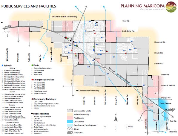
1. Introduction
a. Community Services Department
The City of Maricopa Community Services Department is committed to providing services and amenities to enhance the quality of life of Maricopa residents. The Department has established programs, provided leadership and participated in planning and development review activities to ensure Maricopa’s growth includes adequate open space and recreational facilities.
b. Achievements from Previous Planning Efforts
 In 2014, citizens surveyed identified “parks, recreation, and libraries” among the top five most complimented services provided by the City.
The 2006 General Plan included a needs assessment for parks and community amenities. Prioritized among the needs was, as it was then described, “[a] district park is a community’s flagship park.” It is with great pride the community now enjoys the Copper Sky Multigenerational Center and Regional Park as the City’s flagship park and community center serving thousands of residents every week. The plentiful recreational opportunities at the Center include an aquatic center, state-of-the-art fitness equipment, softball and baseball fields, interactive playgrounds, multi-purpose sports fields, batting cages, basketball courts, sand volleyball courts, horseshoe pits, a five-acre fishing lake, picnic equipment, dog park and more.
The Copper Sky grounds serve as the major event center for the City, offering plentiful space for large crowds drawn to the unique events that have become part of the City’s proud traditions. The Salsa Festival and Independence Day celebrations are part of the pulse of the City. The expansive recreational development offers a public amenity that enhances the quality of life of all of Maricopa’s residents and neighboring communities.
Prior to the Copper Sky Multigenerational Center and Regional Park, the City constructed Pacana Park, which served as the City’s regional park from 2006 to 2013. This park is a 28-acre active recreation sports complex and the host venue for much of the City’s inaugural events and celebrations, such as the 4th of July BBQ, Salsa Festival, and Fishing Derby.
Within the Heritage District, a minor accomplishment with a fair amount of impact is the creation of Lexington Park. The space provides a pocket park with turfed recreation space providing a much needed stormwater retention basin for the Redevelopment Area neighborhood.
There have been select locations where the City’s Master Trails System has expanded within the natural washes and major utility easements that are adjacent to private development. Additional details are presented in the Parks, Open Space and Trails Inventory (subsection d). Goals and objectives are included in this element as well as the Circulation & Connectivity element to establish a complete pedestrian and bicycle trail system.
The majority of the City’s growth to date has been under the development standards of Pinal County. Since the 2006 General Plan, the City has adopted its own Subdivision Ordinance (2006) and the Parks, Trails and Open Space Master Plan (2008) which regulate private development with contemporary standards for community amenities. These development standards will have greater influence and enhance the quality of life for residents over time as applied to new communities. The same can be expected for the trails system planned through, or along the edge of new development.
c. Role of Private Development
The majority of Maricopa neighborhoods consist of subdivisions that are master-planned with connectivity in mind within the development, however little has been accomplished to connect these developments to surrounding open spaces, schools, and commercial destinations. Most commonly, neighborhood trails and parks are privately owned and maintained by homeowner’s associations (HOAs). The City’s open space policy requires new development to provide neighborhood open space and parks to serve the development’s residential population. Trails located in private development, which serve the connectivity needs of residents within and outside of the development, are required to provide for a continuous public linkage with surrounding residential, institutional, and commercial developments.
Private development efforts must consider many aspects of community design to promote quality of life sought by City leadership and residents alike. To highlight key considerations: the layout of streets, visibility, crosswalk design, usable open space, Crime Prevention Through Environmental Design (CPTED), proximity to potential destinations, and environmental comfort when promoting accessibility and safety of pedestrians and cyclists are all considered for users to fully enjoy open space and recreational amenities. Walkable neighborhoods should be designed to encourage leisure, recreation, and to provide alternative active- transportation options for trips that may relieve dependence on automotive transport.
As directed by the 2040 Vision and community input, there is a strong desire to diversify the housing options available to Maricopa residents. To entice quality multi-family development and greater user-ship of public amenities, the City should incentivize higher density and attached housing development, where appropriate, to directly access open space and recreation facilities.
| Goal G1.c.1: |
Trails and open space design requires emphasis on walkability and connectivity across the property complete with connections to adjacent properties. |
| Objective G1.c.1.1: |
Analyze PTOS Master Plan spaces to advance goals of existing Safe Routes grant funding and future funding opportunities in other areas such as Senior and ADA compatible design and improvements. |
| Objective G1.c.1.2: |
Conduct targeted walkability studies and environmental design audits between likely pedestrian routes (existing or unrealized) in the developed areas of Maricopa. |
| Objective G1.c.1.3: |
City to acquire land dedications or easements adjacent to or within communities, appropriately scaled for planned trails. |
| Objective G1.c.1.4: |
Future developments should incorporate open space, trails, and recreation as an integral design element, providing direct access and visibility to open space corridors from public ways. |
| Goal G1.c.2: |
Incentivize mixed-use and higher density housing in select locations consistent with redevelopment plans, special area plans, and the General Plan Land Use goals. |
| Objectives G1.c.2.1: |
Update the City’s Subdivision Ordinance to incentivize multi-family housing and mixed-use development where appropriate and when adjacent to public open space or a public park. Properly zoned properties within 1/8 mile of a public park of 5 acres or larger should be considered ideal candidates for such an incentive. |
| Objective G1.c.2.2: |
Plan for Town Square Parks within urban/village cores providing opportunities for parks, civic buildings, schools, and gathering spaces to serve as the heart of the village. Park design should reinforce the special character of the specific community it serves. |
| Objective G1.c.2.3: |
Create public and private partnerships, where appropriate, for funding and maintenance agreements of public spaces heavily relied upon by private development. |
d. Parks, Recreation, Open Space and Trails Inventory
As of October 2015, the inventory of planned and constructed public parks, trails, and open space include:
- 4 total City Parks (publicly maintained)
- Copper Sky Multigenerational Center, Regional Park, Aquatic Center (98 acres, active park amenities)
- Pacana Park (28 acres, active park amenities)
- Lexington Park (.34 acres)
- Veterans of Foreign Wars (VFW) Park
- 110+/- total HOA Parks or open spaces (privately maintained)
- 3.55+/- miles of disconnected trail improvements
- Desert Wind Community Park (33.3 acres) – Planned future park dedication as part of the Eagle Shadow Master Planned Community
Aquatic Center Photo
 The range of park and recreation facilities that are privately maintained within new developments, including golf courses, varies greatly. The inventory of facilities privately developed and maintained should be revised and included when preparing a Parks, Recreation and Open Space Master Plan and Needs Assessment for Maricopa. Public amenities should also be inventoried for Needs Assessment.
| Goal G1.d.1: |
Inventory where land acquisition or easements will be required for planned trails. |
| Objective G1.d.1.1: |
Work with HOAs to dedicate land or provide easements where planned trails cross or run adjacent to established communities. |
| Objective G1.d.1.2: |
Pursue Public-Private Partnerships as necessary to achieve this goal. |
2. Needs Analysis and Standards
Standards for the provision of parks, open space and recreation facilities vary from community to community. The City’s Community Services Department is a member of the National Recreation and Parks Association (NRPA). The NRPA has worked with the Commission for Accreditation of Park and Recreation Agencies (CAPRA) to establish a standard set of Level of Service (LOS) criteria. The LOS criteria are established by an independent overview of expert advisers and used nationally as parks and recreation benchmarks. The Community Services Department will continue to apply the most current standards of CARPA to the future planning efforts and Master Plan updates.
In addition to the CARPA standards, participating agencies are sharing data and generating reports on park and recreation amenities through an online database known as PRORAGIS. PRORAGIS provides park and recreation agencies a tool to compare operations and management services with other communities (http://www.nrpa.org).
Many jurisdictions have adopted or modified the NRPA standards for planning and programming purposes in past years. The City of Maricopa utilized the NRPA standards for the 2008 PTOS Master Plan. An update to the PTOS Master Plan should be performed to further define the LOS criteria for the future of the City based on population levels and projected growth patterns.
| Goal G2.1: |
Update the Parks, Trails, and Open Space Master Plan. |
| Objective G2.1.1: |
Take full inventory of PTOS amenities with geographic analysis to ensure adequate levels of service is provided equitably throughout the City. |
| Objective G2.1.2: |
Update Master Plan to reflect current national LOS standards. |
| Objective G2.1.3: |
Obtain and Maintain CARPA Accreditation for the Community Services Department. |
| Objective G2.1.4: |
Support the updated PTOS Master Plan goals within the City’s Capital Improvement Projects as well as within the regulations of the Subdivision Ordinance and Zoning Code, as required. |
| Objective G2.1.5: |
Align the design standards and connectivity network with the goals and recommendations of the Area Transportation Plan. |
| Objective G2.1.6: |
Verify planned trails and open space corridors are to connect with neighboring jurisdictions, especially with the Pinal County plans within the unincorporated area of the planning area. Bicycle and equestrian networks are of interest for ability to assist in regional connectivity. |
| Objective G2.1.7: |
Consider opportunities to expand tourism through recreation destinations and sporting events with regional and national interest. Consider proximity to lodging and Copper Sky for benefits of serving large crowds and overnight stays. |
| Objective G2.1.8: |
Crime Prevention Through Environmental Design (CPTED) and Safescapes should be considered when establishing design standards and recommendations. |
| Objective G2.1.9: |
Support Economic Development goals with quality parks and recreation amenities to attract and retain high-skilled employers and employees seeking a full-service community. |
| Objective G2.1.10: |
Assist in the effort to win recognition as a Walk Friendly Community and Bicycle Friendly Community as identified in the Area Transportation Plan. |
| Objective G2.1.11: |
Evaluate existing Community Service assets to maximize future programming and expansion of uses. |
*Additional Objectives for the PTOS Master Plan Update are throughout this General Plan as they relate to the various elements and topics.
3. Open Space Plan
The Parks, Trails and Open Space Plan included with this element is intended to provide a preliminary indication of the community’s expectations with regard to establishing a system of open spaces that are linked by on and off-street paths and trails, throughout the Planning Area.
As directed by the 2040 Vision, the City is to create or revise dated Special Area Plans or Master Plans to achieve Maricopa’s Vision. The PTOS Master Plan has served to provide much needed early direction for the City. However, much has been achieved and a new focus should look forward. Benchmark standards should revise its level of service standards to the current nationally accepted standards and modify them to meet the specific needs of the community. A revised inventory of PTOS assets is necessary for a comprehensive analysis of progress and projected needs.
As before, the Community Services Department is considered to be lead expert and administrator of the PTOS Master Plan update. The Master Plan will need to refer to the 2040 Vision and the General Plan to ensure consistency and support of the mutual direction these long-range policy documents provide. A robust public outreach and public involvement plan should be in place to echo the public sentiments and priorities for the future of Parks, Trails, Open Space, Libraries and related resources. In recent years, the City has benefited from quality community engagement offering a wealth of feedback to access.
a. General Open Space
This category includes all open spaces that are available to the general public for recreational use. To ensure open space is planned for and adequately maintained into the future, the City maintains Open Space Standards through the Subdivision Ordinance and Zoning Code. The allocation of open space is based on both density and scale of residential developments. Open space serves a number of uses for stormwater retention, parks, play fields, greenways, trails, buffer between uses, and landscape. Conditions of open space can be grass lawns, natural desert, lush landscapes, or a mix of these elements. As open space becomes programmed and amenitized for recreation and social gatherings it is counted additionally as parks and trails in a variety of categories listed below.
Maricopa has a number of wash corridors serving as passive open space and they provide opportunities for greenbelts that traverse the City and planning area. Washes are linear and weave through the community to provide connectivity within and to abutting jurisdictions once equipped with multi-use trails. Washes within the desert provide not only drainage for the area but also recreational opportunities and additional mobility. These washes, in addition to utility and canal corridors, provide the backbone for open space connectivity and linkages necessary to serve existing and future residents of the City. Although there are few washes with improved trails today, the master trails plan calls for the washes to have a multi-use trail on either side of the washes: Vekol, Santa Rosa, and Santa Cruz. The Santa Rosa Wash is mostly developed on both sides, and there were opportunities missed early in the City’s development to have portions of the trails improved as part of the abutting subdivision improvements.
| Goal G3.a.1: |
Plan and construct multi-use trails along Santa Rosa Wash to serve existing neighborhoods. |
| Objective G3.a.1.1: |
Acquire necessary easements and rights of way to construct a continuous multi-use trail system along the Santa Rosa Wash from the Gila River Indian Community to the Ak-Chin Indian Community. |
| Objective G3.a.1.2: |
A Master Park and Trail design shall incorporate PTOS direction and the Master Transportation Plan policy and design standards. |
| Objective G3.a.1.3: |
Consider a complete loop trail design with access to the west along Bowlin Road to provide a connection to Copper Sky Regional Park. |
| Objective G3.a.1.4: |
Incorporate a wayfinding signage plan to direct trail users. |
Along with serving the residents, the washes provide wildlife corridors as well without compromising safety of vehicles since the roadways bridge over the washes. Open space works well with land conservation efforts and protecting natural habitats. Future wash and drainage channel improvements should incorporate an ecological approach, and design facilities to function and appear natural.
Open space will continue to be monitored and compared to peer cities and NRPA standards to track Maricopa’s standing in this essential asset for both its practical benefits and beautification of the City’s landscape.
“The vision for the Santa Rosa Wash is verdant corridor that residents can walk or bike through via access from their neighborhoods or parking lots at arterial roads. The site would include recreation activities such as picnicking, open multi-use turf, dog parks, basketball courts, and children’s playgrounds located along the way. The wash will continue to serve as a storm water conveyance but will be transformed into a community multi-use area. The wash is a critical corridor for multi-use paths and trails and is vital in providing a connected off-street pedestrian and bicycle network.”
-PTOS Master Plan
| Goal G3.a.2: |
Design future wash improvements as an integral open space element to surrounding development. |
| Objective G3.a.2.1: |
The Design of communities and neighborhoods abutting or including washes shall integrate the wash corridors as a functional design component and include amenities and trails to accommodate pedestrians, runners, cyclists, (and equestrians when designated as such) as a means to access schools, neighborhoods, and commercial uses. |
| Objective G3.a.2.2: |
Designs of the washes are to include diverse amenities, recreation, and destinations throughout the corridor. |
| Objective G3.a.2.3: |
The washes are to continue to serve as valuable wildlife habitat and corridors for native plant and animal species. |
| Objective G3.a.2.4: |
Washes should be designed to provide direct and frequent access from trails to abutting neighborhoods and roadways. |
| Objective G3.a.2.5: |
Update codes and ordinances governing wash and drainage channel improvements to implement the goals of this Plan. |
b. Public Health and Recreational Activity Opportunities
There is a growing awareness that public health is impacted by a community’s level of access to open space conducive to active recreation. Additionally, Maricopa residents rely on personal motorized transportation for a majority of trips. Studies find that more time driving leads to less time for exercise, civic engagement, as well as to negative health outcomes of sedentary behavior such as obesity and cardiovascular disease.
Public health should be a consideration when performing the needs assessment for Maricopa residents. When health considerations are involved in traditionally non-health sectors and all policies, it has proven to improve the health outcomes for City residents across the country. The City should explore the incorporation of Health Impact Assessments (HIA) as a policy development tool and to establish health related performance measures for future land use and development decisions.
2040 Vision: Parks and Recreation services support citizen health, environmental cohesiveness and community pride.
4. Parks & Trails
The 2008 PTOS Master Plan provides detailed evaluation for Maricopa’s unique circumstance and is the City’s guiding parks, trails, and open space long-range planning policy. The plan includes definitions of the types of facilities, and optimal facilities and services based on public sentiment, population, and other unique factors to Maricopa. The Master Plan outlines policy for Open Space, Park and Recreation Facilities, Paths and Trails, and Implementation Plan for Maricopa and the greater planning area. Pursuant to Goal 2.a.1 of this element, the PTOS Master Plan is anticipated for update to account for the changes that have occurred since 2008 such as Park and Recreation improvements, rapid growth, public sentiment, and changes in land use patterns.
In lieu of an updated PTOS Master Plan, current 2008 PTOS Level of Service (LOS) standards are utilized and outlined below. Future adopted LOS standards should take precedence and serve as the City standard.
Table 9—PTOS Master Plan Service Standards
| Type of Park |
Acres |
Geographic Service Area |
LOS Population Served |
| Grand Park |
200+ |
3 mile radius |
50,000+ |
| Community Park |
20-79 |
3 mile radius |
10,000 - 50,000 |
| Neighborhood Park |
10 |
½ mile radius |
5,000 |
| Village Park |
80-200 |
3 mile radius |
50,000+ |
| Special Use Parks |
Variable |
Variable |
Variable |
| Neighborhood (HOA) Parks |
.33 - 2 |
¼ mile radius |
250-500 |
a. Neighborhood & HOA Parks
Maricopa has a large number of private HOA parks and open space within existing neighborhoods. This has offered a variety of recreation opportunities within walking distance of most residents. Diligent enforcement of existing open space and subdivision ordinances are critical to ensuring residents continue to have adequate access to these neighborhood level services. This will enable the City of Maricopa to concentrate on the large scale Community, Village and Grand Parks.
The smaller Neighborhood Parks are also referred to as Pocket Parks, Tot Lots, and Mini Parks. Pocket parks are typically planned in new residential communities maintained by an HOA, or a retrofit strategy where an aging neighborhood has unmet open space and recreation needs. Additional benefits include centralized water retention solutions to reduce flood hazards and to provide a park closer to home safer for children who may otherwise have to cross busy roads. Parks are typically beneficial to quality of life and property values for a community, and thus a potential tool for revitalization. At the time of this General Plan adoption, the only Neighborhood Park constructed, owned, and maintained by the City is the 13,000 square foot Lexington Park constructed in the Heritage District. The neighborhood served by this park is located in a redevelopment area and was previously underserved by park and drainage facilities. The City also owns and operates the VFW Park, which serves members and patrons of the VFW and the abutting neighborhood.
| Goal G4.a.1: |
Improve parks and recreation access in underserved areas. |
| Objective G4.a.1.1: |
Establish a policy for converting small-scale properties to pocket parks in the instance of property donation or City acquisition. Target abandoned properties in neighborhoods underserved by park space and stormwater retention. |
| Objective G4.a.1.2: |
Conduct geographic analysis to identify any potentially underserved areas regarding park, recreation, and open space based on LOS standards. |
| Objective G4.a.1.3: |
Analyze improved park access in the Redevelopment Area Plan update with special emphasis on the impact of the SR-347 overpass. Scrutiny for connectivity and integration of parks and amenities are critical in the success of the project and the surrounding areas impacted. |
| Objective G4.a.1.4: |
Promote social and cultural ties to the community through public gathering spaces, neighborhood theming, and well-connected communities. |
| Goal G4.a.2: |
Establish Parks, Trails, and Open Space amenity standards to meet the expectations of Maricopa residents. |
| Objective G4.a.2.1: |
Evaluate need and consider best practices to incorporate ADA accessible and special needs playground equipment for inclusion in public and private park facilities |
| Objective G4.a.2.2: |
Update the minimum code requirements for open space and amenities to meet LOS identified in the PTOS Master Plan. |
| Goal G4.a.3: |
Parks and public buildings should function symbiotically. |
| Objective G4.a.3.1: |
Seek to provide affordable meeting space within parks and public buildings as project opportunities arise. |
| Objective G4.a.3.2: |
Parks should serve as spill-over space for functional expansion for special events or unique settings. |
b. Community, Village and Grand Parks (i.e. Copper Sky Multigenerational Center and Park)
Community, Village and Grand Parks provide the broadest open space recreational opportunities and are the community’s flagship parks for sponsoring community wide events. They are a destination park for a large segment of the City. These parks should be centrally located so all residents of Maricopa, to the extent possible, can enjoy geographic equity. The PTOS Master Plan identifies approximate locations for each Community Park throughout the planning area with the intent to serve the greatest number of people with the least amount of travel time. The locations are not intended to identify actual parcels, but a general vicinity for future park locations. The conceptual locations are largely placed along drainage corridors or within floodplains. This would allow floodplain land within Maricopa to be used with greatest efficiency while still maintaining natural drainage patterns. More importantly, this enables pedestrian and bicycle linkages to Community Parks throughout Maricopa’s open space network by way of the multi-use trail system.
Community, Village and Grand Parks should be accessible to many neighborhoods and their LOS service area, providing parking, safe bicycle and pedestrian access as well as intensive recreation opportunities. These parks usually include all of the uses contained in neighborhood Parks, as well as additional acreage for athletic fields, courts, and special use facilities such as urban lakes, skate parks, large group picnic facilities, recreation centers, etc. These larger parks may also include fire/police stations, libraries and commercial development. They provide opportunity for regional and national sport tournaments, and can be an important resource to attract economic development and tourism.
c. Special Use Parks
Special use parks are a critical element of the open space network. These parks preserve the history and essence of what makes the City of Maricopa unique. As the City grows, the preservation of this history and character will connect new residents with the longtime residents of the areas. The PTOS Master Plan recommends preserving unique farming structures, historical structures, and archeological sites, such as the Water Tower, as special use parks. The Redevelopment Area Plan also reinforces the need for unique park sites and amenities that celebrate the history and culture of the City within the Heritage District, and offer a venue for events, farmers markets, and gatherings. Refer to the Heritage District Redevelopment Area discussion.
| Goal G4.c.1: |
Utilize Special Use Parks to establish and reinforce the character and identity of the Heritage District and Maricopa’s farming heritage. |
| Objective G4.c.1.1: |
Analyze feasibility to implement provisions of the Redevelopment Area Plan and PTOS Master Plan to create a Railroad Heritage Park and Farmstead Heritage Parks. |
| Objective G4.c.1.2: |
Update the Redevelopment Area Plan to study feasibility for parks, recreation, and trail linkage opportunities in the Heritage District in conjunction with the SR-347 Overpass design and improvements. |
A Special Use Park is also a park dedicated to a specific or single purpose recreational activities such as golf, nature centers/preserves, equestrian staging areas, amphitheaters, performing arts, or sports complexes, in addition to recreation centers that provide a variety of special events and activities. Their purpose is to enhance the multi-use year-round recreational opportunities for residents of Maricopa.
Planning Area Special Parks
Throughout Maricopa’s planning area there are a number of open spaces and significant cultural resources that offer a great benefit to area residents and visitors. The City works to support and enhance these open space and recreation amenities through participation and available resources.
Palo Verde Regional Park, Pinal County
Pinal County has implemented a Capital Improvement Plan to design and develop a 23,000 acre regional park and open space preserve in Maricopa’s western most planning area, between SR-238 (to the north) and Interstate 8 (to the south). The park includes portions of the Palo Verde Mountains, access to the Table Top Wilderness area and Sonoran Desert National Monument, and other significant natural open spaces and trails. This land was designated as a future regional park on the 2006 Maricopa General Plan Future Land Use Map and will provide a valuable open space and park resource for Maricopa and the greater planning area, once complete.
Pinal County, with input from the City of Maricopa and residents, began the specific master planning process in 2015. Maricopa and the planning area are tremendous beneficiaries of this Regional Park. Considerable attention to the planning process and thoughtful input is critical to creating a usable park and a regional attraction.
Juan Bautista de Anza National Historic Trail
In 1775 Jaun Batista de Anza led 240 men, women, and children on an epic journey to establish the first non- Native settlement at San Francisco Bay. Today, the 1,200-mile Juan Bautista de Anza National Historic Trail connects history, culture, and outdoor recreation from Nogales, Arizona, to the San Francisco Bay Area. The National Historic Trail is located in the northwest most corner of the Maricopa Planning Area, crossing from the north boundary to the west boundary, north of the SR-238. This location is anticipated for a future historic monument and trailhead celebrating this unique cultural artifact and is a part of Maricopa’s PTOS Master Plan. Pinal County has identified an alignment that follows the SR-238 corridor, as shown on the Park and Open Space Map.
| Goal G4.c.2: |
Pursue potential partnerships and collaboration with Pinal County for open space, trails, and amenity planning. |
| Objective G4.c.2.1: |
Evaluate opportunities for open space, amenities, and connectivity to Pinal County Parks and Trail features in the PTOS Master Plan Update, including the Juan Batista De Anza National Historic Trail, Sonoran National Monument, Palo Verde Regional Park, Thunderbird Equestrian Arena, and West Pinal Park. |
d. Paths and Trails – Paved and Unpaved
Paved Paths with Wide Shoulder are also known as Shared-use Trails or Multi- use trails in the City’s Master Plan documents. These multi-modal trails are the predominant type of trails within the City’s master trails system. They are used throughout the planning area to connect neighborhoods with landmarks, shopping and services, and parks and open space areas and are made of dual surface materials to accommodate a diverse group of users. For the paved portion of the path the preferred surface material is concrete, however asphalt is acceptable. This paved facility is used by bicyclists, pedestrians, joggers, strollers, wheelchair users, in-line skaters, other non-motorized users, and anyone wanting a smooth and consistent surface. The unpaved shoulder adjacent to the paved path should be a minimum of 4’ wide and is designed to accommodate users who prefer a softer surface.
Paths should be signed for various users, are primarily ADA accessible and may also be used by small maintenance and emergency response vehicles. Standards may vary according to Right-of-Way (ROW) width, existing or anticipated level of use, geographical and environmental constraints, and land uses. The typical minimum Paved Path width is 10’. The paved path master trail system includes regional and local connections. The system is designed to provide a variety of loops that connect neighborhoods to all types of destinations and unpaved trails and offer opportunities for trail dependent community events.
Unpaved paths are often designed to accommodate equestrian and pedestrian users. Signs, crossings, vegetation, rest and staging areas developed in conjunction with these paths may be primarily designed to accommodate equestrians. Unpaved paths may also be within utility and canal easements in order to allow utility access while achieving neighborhood connectivity. The PTOS Master Plan identifies the different types of unpaved trails anticipated for Maricopa and includes: Back Country Trails, Rural Neighborhood Trails, and Community Trails.
| Goal G4.d.1: |
Expand the Master Planned Trails System to promote greater connectivity throughout the City. |
| Objective G4.d.1.1: |
Seek out and pursue federal, state, and local grants to assist with funding. |
| Objective G4.d.1.2: |
Prioritize the paving and improvements of planned trails that are currently unimproved yet have the greatest accessibility to established neighborhoods. |
| Objective G4.d.1.3: |
Prioritize the paving of planned trails that will connect residential land uses with other developments, such as schools, retail, services and employment, which can reduce dependence on motorized transport. |
| Objective G4.d.1.4: |
Prioritize the paving of planned trails that will connect the developed communities north and south of Maricopa-Casa Grande Highway and the Union Pacific Railroad to relieve the City from the physical barrier to unite the north and south portions of the City. |
| Objective G4.d.1.5: |
Coordinate work plans and Capital Improvement Project (CIP) line items to achieve the goal and objectives above. |
| Objective G4.d.1.6: |
Overlay with projected future roadway improvements for years 2020 and 2030 are located within the current Transportation Master Plan. Consider intersections with trails and adjacent improvements in coordination with these timeframes. |
| Objective G4.d.1.7: |
Adopt trail signage, lighting, and wayfinding standards and programs to encourage broa |
* refer to Circulation & Connectivity Element for additional trails discussion
e. Bicycle & Pedestrian Network
To maximize the function of roadside sidewalks and bicycle lanes (also refer to Circulation & Connectivity Element), multi-use trails must also be enhanced. The Trails Master Plan should consider future enhancements for corridors with the potential for a high volume of bicycle traffic with additional markings and traffic controls. A phased approach will prepare the City to be responsive to cyclist needs if and when presented with the demand.
With regard to Parks, Recreation, and Open Space, the bike lanes should be designed to intersect with multi- use trails in a safe manner while promoting greater connectivity and a robust circulation network for cyclists. The PTOS Master Plan provides guidance in creating entry nodes and access points, as well as trailheads, multi-modal trail crossings at intersections, and other standards for unique circumstances.
| Goal G4.e.1: |
Plan for details to integrate bicycle lanes with multi-use trails. |
| Objective 4.e.1.1: |
Adopt design details for the intersection of bicycle lanes and multi-use trails to ensure safe and efficient intersections and trail entry locations. |
| Goal G4.e.2: |
Explore expanding the Wayfinding system envisioned within the 2015 Area Transportation Plan. |
| Objective 4.e.2.1: |
Include guidance to connect trails to local and collector streets to maximize the entire network. |
| Objective 4.e.2.2: |
Include guidance to direct pedestrians and cyclists to landmarks and parks and recreational spaces. |
| Objective 4.e.2.3: |
Explore local and regional branding opportunities for the Wayfinding system to recognize appropriate assets and future opportunities within the system. |
5. Public Art
Art and architecture set themes and distinction for villages and corridors in many cities and towns. Maricopa residents expect no different from their own city and desire public art and distinct architecture to establish character and interest within spaces and incorporated into buildings or structures. Arts and culture, when appropriately embedded into the context of a setting to provoke identity, inspires social and public assembly referred to as placemaking.
A theme is taking hold around the Copper Sky Multigenerational Center building that borrows from its design elements and color pallet. Public art should serve the same purpose. The SR- 347 overpass serves as a prime opportunity to showcase artistic talent and promote the design theme of the Heritage District and the adjacent properties as they redevelop.
2040 Vision: Opportunities for recreation, cultural enrichment, and social interaction make the City more attractive to its citizens. Adopt policies to provide desired and attractive amenities to drive quality growth and development.
| Goal G5.1: |
Create a committee to guide and promote the Arts & Culture in Maricopa and provoke identifiable spaces and places through the use of arts and culture (placemaking). |
| Objective G5.1.1: |
Develop a comprehensive program for encouraging art in Maricopa that includes a policy for displaying art in City facilities. |
| Objective G5.1.2: |
Seek funding sources to offset expenses associated with public arts initiatives and project construction. |
| Objective G5.1.3: |
Oversee the adoption of a wayfinding policy and guide to assist pedestrians and cyclists navigate to activity centers, parks, trailheads, and trail circuits. |
| Objective G5.1.4: |
Target entryways, gateways, streetscapes, and other features to delineate various neighborhoods or districts. |
| Objective G5.1.5: |
Identify possible partnerships to facilitate programs and locate venues to accommodate art education and exhibits, music institutions, and opportunities for performing arts |
| Objective G5.1.6: |
Work with staff and City Council to create the Committee’s oversight responsibilities and structure. |
| Objective G5.1.7: |
Evaluate the opportunities, needs, and sentiment for a public Performing Arts Center. |
| Objective G5.1.8: |
Incorporate the Committee into a strategy to attract resorts, hotels, convention facilities, and other venues to accommodate a variety of events, art education and exhibits, music institutions and opportunities for performing arts. |
Sections of this Element:
- Public Buildings
- Public Services and Facilities
- Utility Services
- Functional Plans
- Cost of Development Element
Ensuring adequate public facilities and services demonstrate the City’s commitment to orderly growth. Certain services, like water and wastewater utilities, are privately provided in Maricopa, highlighting the need for cooperative efforts in maintaining acceptable levels of service at reasonable costs. The availability of public services and facilities will enable Maricopa to meet its future population expectations, accelerate growth in desired areas of the community, and, if needed, the flexibility to constrain development where growth is not desired. Developer provided infrastructure, coordinated with the City’s efforts, is an important component of this Element.
As a rule, public facility planning in a developing community like Maricopa should be directed to meet three important criteria:
- Service standards that are adequate and equitable for all parts of the community;
- Service to new developments that is cost-beneficial to the City’s citizens; and
- Financing that maximizes the long-term value of local government assets.
Carefully planned and implemented facility expansions and service extensions can maximize the return on investments by the City, School Districts, the private sector and other levels of government.
As Maricopa matures, new functions, public and private facilities, and income producers add new dimensions to the community. As public facilities and services continue to be established, a broadened revenue base can support these and other desired investments. The City and community are committed to expanding public facilities and services to meet citizens’ needs.
The citizens of Maricopa desire a “Smart City” approach as a path for enhancing the performance of City facilities and infrastructure, reducing costs and resource consumption, and engaging more effectively and actively with its citizens. This approach integrates technology and government with the intent to empower planning efforts and infrastructure development to create a more attractive and efficient city for residents, visitors, and businesses/employers. “Smart Cities” is an integral aspect of the Vision 2040 Strategic Plan adopted by the City Council May, 2015 with equal importance in this General Plan.
1. Public Buildings
Maricopa acknowledges the vital role public buildings play in shaping community life, and the city seeks to design facilities that represent the community’s special qualities. Public buildings are designed to respond to the needs of the community, and as such, the location, size, timing, and financing of public buildings must be planned well in advance of construction to minimize cost and maximize function. For new buildings, the City will lead by example in constructing facilities that reflect the community’s character and history, while maximizing usefulness and public benefits for generations to come.
Maricopa maintains City Hall, Police Station, Copper Sky Multi-Generational Center and Park, Copper Sky Police Substation, Pacana Park Maintenance and Concession buildings, Library, Public Works Building and Equipment Yard, Fire Maintenance facility, Copa Center Community Building, VFW Facility, Don Pearce Fire Station Community Room, four (4) fire stations and the Fire Department Administrative offices. The City operates centrally from City Hall located at 39700 W. Civic Center Plaza.
In 2010, City leadership undertook community outreach and visioning exercises to capture the citizens desires to assist the planning and design of a variety of City facilities: the City Hall Complex, Regional Park, Aquatics Center and a Multi-Generational Center. A result of the citizen outreach process was the conceptual design of the future City Center Complex, which includes a City Hall building and spaces for other public buildings and City services, a civic mall open space, a performing arts and cultural center, and a museum all located in the heart of a 145 acre mixed–use development.
In 2013, the City opened the new City Hall that was designed to embody the citizen’s desire for transparency and connectivity. The building and surrounding area is designed for expansion to support the growth of the City and meet the needs of Maricopa through build-out. The City Hall building is positioned on a highly visible site and raised on a plinth to create a civic presence. The architecture expresses an outward-reaching connection between the City’s programs and services and the community. To honor its past, materials symbolic to the city’s history, such as stone, ground-face masonry and metal panels are melded with concrete, steel and glass that express the city’s future.
City Hall offices house the City Council Chambers, City Council offices, City Management and administrative offices, Finance Department, Economic Development, Development Services, Engineering, Community Services, Information Technology, and the City Clerk offices.
Interactive Maps (GIS)
Figure 12-Public Buildings and Facilities Map
2. Public Services and Facilities
The service level provided by Maricopa’s public facilities has progressed significantly since incorporation. Facilities that once supported the original rural community have evolved and expanded to service large master planned developments. Municipal infrastructure is a mix of components that vary in quality, differ in capacity, and may involve multiple service providers or jurisdictions. Most facilities are newer, installed by developers, utilities, or by the City; others are older and require major maintenance, expansion, or replacement. Some essential public facilities, including higher education and medical services, are emerging in Maricopa.
Recently developed areas of the community are designed and constructed with urban infrastructure and services. Older neighborhoods, less dense and more rural in character, are usually served by water, on-site waste disposal (septic), and street systems designed for their level of need at the time of improvement, and these will not accommodate future growth without additional infrastructure improvements. Public safety functions, such as police protection, have significantly expanded to keep up with the population. Fire services are provided by the City Fire Department and emergency medical service is offered by a contract provider, Southwest Ambulance Service.
2040 Vision: Ensure parity of services among all sections of the City.
This chapter lists the major services provided by the City (Refer to Public Facilities Map) and the issues related to examining future needs and desired levels of service. Some services may be discussed in other portions of this General Plan, such as Open Space & Recreation. As other services develop or new issues arise, the plan will be amended to include them for analysis.
Level of Service
To determine what constitutes an equitable provision of city service, the City of Maricopa must first determine the desired level of service for any service provided by the City or other private and non-profit entities. The method to determine this can be measured in many ways depending on the amenity provided. Examples of this include service per population, per area, or per distance traveled.
When determining level of service it is important to also consider the desired level of service when related to the existing or future intensity of the area. Equitable service planning for Maricopa will look at the sustainability of the service when compared to the number of users and the cost to the City. Fewer services will be provided in rural areas in general and some noncontiguous (leapfrog) development, due to cost of providing the service as well as the fewer number of residents who will benefit from the service. When looking at service levels compared to density it will be important to examine the need of the residents and if there are other areas of the City that have a greater need for the same or different services when budgetary constraints are applied.
a. Emergency Services
Fire Prevention/Suppression
The Maricopa Fire Department (MFD) provides emergency fire suppression and EMS services to all development in Maricopa. MFD is rapidly growing, and will keep growing, to meet new demands in the community. MFD currently has 68 trained firefighters, four fire stations and one administration building. Further, MFD has also recently added major new firefighting equipment to their roster to enhance emergency response preparedness.
Dispatch is handled through Phoenix Regional Dispatch system. MFD is working with the Ak-Chin Fire Department to provide back-up service to one another.
Fire Prevention Services are managed by the MFD, which coordinates fire code enforcement related to new and existing construction. Fire inspections to all commercial, schools, and industrial buildings occur regularly by fire inspectors. Fires are investigated for cause and determination to reduce future fires by educating the community. Emergency operations center has reached out to the community for engagement to promote “Whole Community” approach consistent with FEMA emergency management. FEMA has recognized to partner with organizations like faith-based and nonprofit groups, and private sector to individuals, families who continue to be the nation’s most important assets as first responders during a disaster. Fire prevention has incorporated a Community Emergency Response Teams (CERT) with volunteers who are interested in training for major disasters. An additional function that has been initiated by MFD is public education that extends to all of the Maricopa area schools and special events. MFD has also developed a Hazardous Materials Response Team, designed to provide specialized emergency response to both personnel and equipment to protect the public, the environment and properties. Refer to the Section II. D Safety Element for additional policy discussion.
| Goal H2.a.1: |
Maintain a community in which all residents, businesses and visitors are safe. |
| Objective H2.a.1.1: |
Ensure all future development infrastructures include fiber-optic, proper ingress and egress for efficient public safety including bicycle paths and pedestrian crossings. |
| Objective H2.a.1.2: |
Develop specific initiatives for Homeland Security and the City’s Emergency Operations Center focusing on an all-hazards response to critical infrastructure. |
| Objective H2.a.1.3: |
Achieve optimal staffing levels and facilities, located in strategic areas throughout the City to provide efficient public safety including hazardous material and water rescue. |
| Objective H2.a.1.4: |
Ensure the MFD delivers seamless services to the community. |
| Objective H2.a.1.5: |
Increase opportunities for use of technology and high quality resources. |
| Objective H2.a.1.6: |
Achieve national accreditation for Fire Department |
2040 Vision: Maricopa is a safe and livable community in which citizen involvement supports and upholds the value of being safe and secure in one’s own community.
Police
 The Maricopa Police Department (MPD) began taking calls for service on July 1, 2007. The Department has 66 sworn employs and 11 civilian employees as of 2015. With an approximate population of 50,000, there are 1.32 sworn officers per 1,000 residents. The national recommendation for staffing is between 1.8 and 2.0 officers per 1,000 residents. Adding to the challenge of preserving life and property is the 45 square miles of incorporated land that requires vigilant patrolling. To help meet immediate and future needs of the residents, the Maricopa Police Department moved into its first police station and headquarters in November of 2013. The headquarter facility acts as the first permanent facility in the history of the department. MPD plans to open the second permanent facility in January 2016.
As part of the effort to maintain a consistent level of high performance, the Maricopa Police Department has made strides in accountability, professionalism, and community engagement. The Maricopa Police Department was able to complete the initial accreditation with the Commission on Accreditation for Law Enforcement Agencies (CALEA). CALEA accreditation is the highest form of national accreditation currently offered to law enforcement agencies.
Due to the fact that the first four minutes of any emergency are critical, it is the goal of MPD to be on scene within four minutes of the 9-1-1 call. Currently the response time is more than five minutes. Maricopa has relied on contracted 9-1-1 services through Pinal County Sheriff’s Office (PCSO) and then Buckeye Police (BPD) since the inception of the police department in July, 2007. All 9-1-1 calls made within Maricopa are answered either by PCSO and then transferred to the City of Buckeye Police Department Public Safety Communications Center or they are answered directly by the City of Buckeye. Upon completion of the Police Communications Substation discussed below, MPD will take full control of police and emergency dispatch serving Maricopa. Furthermore, Section II. H2 .i Communications subsection explains public communications in the event of an emergency.
Maricopa has worked to keep pace with meeting the public safety needs. A new police substation opened in 2016 to house the Maricopa Police Department Communications Division and an expanded Property and Evidence facility. Furthermore, the new substation provides emergency and policing presence south of the railroad tracks and the neighboring Copper Sky Recreational Complex. The facility also provides expanded, walk-in access to policing personnel through the 24/7/365 communications and dispatch center. The facility expands the deployment of resources currently available to MPD and the citizens of Maricopa. Finally, the new substation houses a regional emergency operations center and training facility. These features allow MPD to create and maintain partnerships and emergency communications with regional and national public safety providers, including the municipal police departments in Pinal County.
Moving forward, the MPD is actively pursuing Smart City technologies to improve operational efficiencies. The MPD has launched a mobile app to allow residents and businesses to keep up with MPD news and updates, as well as report crimes and suspicious activities on their mobile devices. MPD is also implementing new technologies for monitoring public facilities and parks 24/7. Refer to the Section II. D Safety Element for additional policy discussion.
| Goal H2.a.3: |
Increase meaningful citizen participation in community policing efforts, especially in neighborhoods. |
| Objective H2.a.3.1: |
Promote efforts and successes in making Maricopa safe through enhanced website and meaningful partnerships with local and regional media. |
| Objective H2.a.3.2: |
Create Neighborhood Watch programs in all areas. |
| Objective H2.a.3.3: |
Involve public safety officials in the City’s planning process (e.g., review plans to ensure incorporation of public safety concepts). |
| Objective H2.a.3.4: |
Create liaisons to facilitate the development of neighborhood groups and activities. |
| Objective H2.a.3.5: |
Expand the services provided for community organizing, creating and maintaining citizen involvement (e.g., partnering with neighborhood HOA’s). |
| Objective H2.a.3.6: |
Continue to provide City sponsored mechanisms for citizen input (e.g., coffee with the Chief, town hall meetings, public forums, Public Safety Citizens Academy, etc.) |
| Objective H2.a.3.7: |
Engage citizens in the building of community and neighborhood safety programs. |
| Goal H2.a.2: |
Maintain a community in which all residents, businesses and visitors are safe. |
| Objective H2.a.2.1: |
Create and implement policy for Crime prevention through Environmental Design to improve public safety in existing and new development. |
| Objective H2.a.2.2: |
Conduct a study to evaluate lighting levels throughout the City. |
| Objective H2.a.2.3: |
Adopt civil and criminal abatement ordinances and policies. |
| Objective H2.a.2.4: |
Incorporate into the City’s Development and Redevelopment plans, Urban and community Crime Prevention design concepts that adhere to national standards and promote public and neighborhood security and safety. |
| Objective H2.a.2.5: |
Design and implement effective community policing programs and strategies. |
| Objective H2.a.2.6: |
Achieve optimal staffing levels and facilities, located in strategic areas throughout the City to provide efficient public safety response. |
| Objective H2.a.2.7: |
Maintain national accreditation for Police Department. |
| Objective H2.a.2.8: |
Increase opportunities for use of technology and high quality resources. |
b. Courts
The Pinal County Complex in Maricopa at 19955 N. Wilson Ave, houses the court services that serves Maricopa. As of July 1, 2004, the City of Maricopa began operating under a consolidated court system with Pinal County. The City has elected to use a consolidated court based on increased efficiency and lower costs.
c. Community Services
The City of Maricopa Community Services Department is committed to providing services and amenities to enhance the quality of life of Maricopa’s residents. The department offers a variety of diversified programs, activities and special events that focus on family, fun, recreational needs, inclusion programs, and physical wellness of children, adults and seniors. Parks and other public facilities enhance the quality of life of Maricopa residents, provide a place for families and friends to gather and add to the amenities offered to many visitors. The Community Services Department is comprised of the following four (4) divisions:
- Library
- Parks
- Recreation
- Events
Library
 There is one public library in Maricopa that is part of the Pinal County Regional Library System. The library is located on a one-half acre site at 41600 W. Smith-Enke Rd, Building #10. The library is approximately 8,000 square feet in size and has a collection of over 40,000 books, journals, cd’s, dvd’s, videos, etc. The Library provides full library services, materials in all formats, programming for all ages, and 20 public access computers. As the population grows, this facility, too, will need to keep pace with increasing demand. A growing and expanding library network, equipped with the latest technology and quality programming betters the community by supporting education, community togetherness and both personal and econoimic growth.
Libraries built in the future should be located and designed as a central part of the community. The library serves less as a research center and more as a place for art display, continuing education center, social gathering and leisure space and any other use the public may have. A location that can provide this much to a community becomes a central piece in making a public place.
2040 Vision: The City provides and maintains quality facilities and programming for information resources, educational support and community interaction.
Public library services are based on relationships and interactions between staff and library users. Today’s library staff is one that instructs and interacts with customers to insure a library experience that is gratifying and relevant to the customer needs and expectations. Library staffing must be available to meet the needs of each age group, engage in community outreach, and to plan and coordinate the cultural and educational offerings of the library. In 2015, Library facilities in Maricopa are below that recommended by the Library Master Plan and the library facilities per capita based on the national average.
| Goal H2.c.2: |
Implement Library resources and facilities necessary to maintain the industry standard level of service. |
| Objective 2.c.2.1: |
Update the Libraries Master Plan in conjunction with the PTOS Master Plan update and implement a plan to meet the recommendations for level of service standards for Library services in Maricopa, including a new Library. |
| Objective H2.c.2.2: |
Consider peer community levels of service when planning for Library facilities. |
| Objective H2.c.2.3: |
Expand library services to provide public access to communications and information technology. |
| Goal H2.c.1: |
Encourage the creation and expansion of a wide array of community-oriented services, and the ability of residents to share such services. |
| Objective H2.c.1.1: |
Identify and utilize strategic placement of library facilities (both new and existing public or private spaces) to encourage participation and partnerships i.e., near gathering centers and educational facilities. |
| Objective H2.c.1.2: |
Create and maintain strong partnerships with other libraries to build a supportive network of resources. |
| Objective H2.c.1.3: |
Identify and support opportunities to place and expand strong, reliable technologies for connectivity on a worldwide level. |
| Objective H2.c.1.4: |
Ensure quality staff training and education to support research assistance, at multiple levels, both privately and through business resource centers and partnerships. |
| Objective H2.c.1.5: |
Explore opportunities to enhance usage of facilities, including the availability of multi-media, interactive and artistic modes. |
| Objective H2.c.1.6: |
Maintain a strong community connection through programming designed towards social and intellectual interaction among community members. |
| Objective H2.c.1.7: |
Explore extended library services to underserved populations, such as book and media delivery to home-bound residents. |
| Objective H2.c.1.8: |
Preserve history and culture through public facilities and private partnerships in the form of a history museum, auditorium, cultural center, etc. |
Parks
This division is responsible for community park facilities including fields, playgrounds, courts, trails, restroom buildings and ramadas.
| Goal H2.c.3: |
Create and maintain a responsibly connected system of open spaces throughout the City. |
| Objective H2.c.3.1: |
Implement responsible landscaping that facilitates conservation of water and other resources. |
| Objective H2.c.3.2: |
Utilize landscaping and hardscaping to provide shade and strategically placed water availability to encourage broad use. |
| Objective H2.c.3.4: |
Conduct a study to evaluate and improve the levels of lighting throughout the City parks. |
Recreation
Residents envision Maricopa providing areas of open space and facilities for parks, recreation and leisure that serve the population and its interests through flexible planning and responsiveness to the community. The Recreation Division helps deliver this vision by providing year-round programs that include coordinating adult sport leagues, youth sports, special events, instructional classes and programs for youth, teens, special needs and senior citizens.
In 2010, City leadership undertook community outreach and visioning exercises to capture the citizens desires to assist the planning and design of a variety of City facilities, including a Regional Park, Aquatics Center and a Multi-Generational Center. A result of the citizen outreach process was the 140 acre Regional Parks Master Plan, which includes a Multigenerational Center, Aquatic Center (now known as Copper Sky Regional Park and Multigenerational Center) with a Police Substation and an 18 acre mixed–use development.
The City opened the Copper Sky Recreation complex in 2014 and is the premier sporting, fitness, recreation and leisure destination in Maricopa. Comprised of the Copper Sky Multigenerational Center, Aquatic Center and the Copper Sky Regional Park, this expansive recreational development offers 98 acres of active recreation space, state-of-the-art equipment, grand green spaces and fantastic programs designed to enhance Maricopa residents’ quality of life. The aquatic facility provides an 8-lane competition pool and a recreation pool with a splash pad, lazy river, slide, diving well, rock climbing wall, with water volleyball, basketball and aerobics. The 52,000 sf Multigenerational Center includes a double-court gymnasium, dance studio, fitness center, walking track, multipurpose/mini-banquet rooms, catering kitchen, child watch, and restrooms/showers.
In addition to Copper Sky, the City opened the 28 acre Pacana Park and recreation facility in 2008, and the 13,000 square foot Lexington Park in 2013. The City also owns and operates three community center facilities. The Don Pearce Fire Station 575 was constructed within the Redevelopment Area and designed to include an 800 square foot community room and event space located within walking distance from Lexington Park. The Copa Center is a larger air conditioned public event space located at 44585 W. Honeycutt Road. Various City classes and programs are regularly held there and open hours are provided for social and recreational activities. The City also owns and maintains the VFW facility located at 44240 W. Maricopa-Casa Grande Highway.
| Goal H2.c.4: |
Create and maintain a system of recreational opportunities throughout the City. |
| Objective H2.c.4.1: |
Periodically evaluate the City’s park needs to be responsive to current interests. |
| Objective H2.c.4.2: |
Foster and maintain relationships with private and public entities to provide multi-use recreational facilities that promote fitness and activity. |
| Objective H2.c.4.3: |
Encourage green belts and natural areas to allow for flexible and multiple uses. |
| Objective H2.c.4.4: |
Assess needs and implement policies to provide special needs and ADA accessible recreation equipment for public and private amenity features. |
| Objective H2.c.4.5: |
Evaluate recreation facilities and programing in the PTOS Master Plan Update identified in the Open Space & Recreation Element Goals. |
Events
The Events Division programs large and small scale events throughout the year to provide opportunities for local community members to enjoy cultural, social and educational activities. Maricopa has a long tradition of celebrations and partnerships. Stagecoach Days, Maricopa’s original celebration that started in the 1950’s, inspired other events such as Salsa Festival, Merry Copa, and the Great American Fourth. The enduring history of Maricopa traditions provides a thread that connects the past, present and future to the citizens of Maricopa.
2040 Vision: Maricopa is an attractive and appealing city; a great place to live, work and play. Maricopa works to highlight and enhance our amenities as a City, to promote a positive and professional image, and foster regional relationships.
| Goal H2.c.5: |
Foster and sustain community events that maintain our heritage while engaging the citizens of Maricopa. |
| Objective H2.c.5.1: |
Identify the traditional events that are vital to sustaining the heritage of Maricopa. |
| Objective H2.c.5.2: |
Create opportunities to enhance citizen participation in community events. |
| Objective H2.c.5.3: |
Leverage these events to foster our relationships with our partners. |
| Objective H2.c.5.4: |
Explore, create and maintain opportunities to share Maricopa events with regional or greater audiences. |
| Objective H2.c.5.5: |
Identify venues such as resorts, hotels, convention facilities, and other public or private spaces to accommodate a variety of events, art education and exhibits, music institutions and opportunities for performing arts. |
d. Human Services
Human Services facilitates the consideration of physical and mental health, and social well-being, within the land use planning process. It sets forth human values and principles which are to be taken into account as Maricopa grows. It provides the basis for assuring the social and health needs of all residents are met and there is an opportunity to provide services in appropriate settings to achieve the highest quality of life and productivity.
Inclusion of this element in the City of Maricopa General Plan represents an important policy advance. While the intent is to promote public convenience, consideration of the need for planned social and health infrastructure can be overlooked. There is a need for long-range comprehensive human services planning that places human service concerns on the same level as physical development in the planning process and based upon fundamental principles.
Human Services is broadly defined to include all of those community services which provide support and protection for individuals and families including services in the following areas: food and shelter, employment and training services, education services, financial services, physical and mental health care, dependent care, substance abuse services, protective and supportive services, legal and criminal justice services.
Planning to meet the needs of Maricopa’s residents requires understanding of human services assets and gaps as they currently exist as well as how the assets and needs of the residents will change with time. As the City embarks on implementing a comprehensive Human Services Plan, periodic data review and analysis of demographics as well as human service needs, usage and access will be necessary. Collaboration and information sharing with human service providers is necessary to project needs and promote placement of human services facilities as part of the planning process.
With the aforementioned information, a Human Services Plan will be able to identify if an appropriate amount of land and facilities are designated for human service usage. A Human Services Plan will also be able to indicate what types of services are most needed in particular with new growth areas.
| Goal H2.d.2: |
Encourage the Integration of Human Services across all facets of the community. |
| Objective H2.d.2.1: |
Allow for and support the integration of multi-use human service functions within existing and future facilities such as churches, housing, retail and community centers. |
| Objective H2.d.2.2: |
Analyze use of existing facilities, co-location options and alternative facility configurations as a cooperative effort among human service agencies as a component of the overall facilities planning process. |
| Objective H2.d.2.3: |
Explore homecare service options, clinics, and programs to promote wellness and active aging. |
| Goal H2.d.1: |
Human Services shall be recognized as an integral part of the community and are physically accessible to all residents. |
| Objective H2.d.1.1: |
Encourage public and private partnerships to support quality public health, social services and health education, including domestic violence shelters and veterans’ needs. |
| Objective H2.d.1.2: |
Prepare, Implement, and periodically update a formal Human Services Needs Assessment and Plan which includes all segments of the population. |
| Objective H2.d.1.3:. |
New Human Services facilities shall be appropriately sited adjacent to existing or planned transportation corridors to enhance access to all segments through multiple mobility options. |
| Objective H2.d.1.4: |
Adequate infrastructure (streets, sidewalks, bicycle lanes) and appropriate design elements are incorporated during the planning and review of new human service facilities to improve connectivity and access. |
Community wellness is a topic of increasing concern in communities across the nation. As the “baby boomer” population reaches retirement age, more facilities and services will be required to address the needs of an aging population. With aging, there is also an increase in the number of people with disabilities. The issues associated with this topic go beyond the location and services provided by public and private medical institutions. The overall health of a community depends on multiple factors, including the environment around them. A healthy and active environment reduces health risks and promotes better lifestyle choices.
Providing Maricopa’s senior residents with access to services and amenities is critical to retaining this rapidly growing demographic within the community. Never before has such an educated and accomplished workforce retired, and age-friendly policies are necessary to keeping this population engaged and active in the community.
2040 Vision: Maricopa is a community where residents can gain a true hometown feel; a place where citizens can work and play together and share experiences unique to our City. The City is dedicated to servicing all families, at all ages and stages of life, with professional services and a sense of togetherness.
| Goal H2.d.4: |
Identify and implement effective methods of communication and media sources to inform and educate the Senior population. |
| Objective H2.d.4.1: |
Develop and implement an overall communications strategic plan to provide information about available services, events, and other opportunities to promote senior participation and engagement |
| Objective H2.d.4.2: |
Explore promotion of and access to the use of technology to connect aging residents to their community, friends and family. |
| Goal H2.d.3: |
Maricopa will be an “Age-Friendly City,” a community that connects people 60 years plus with people of all ages in order to improve social interaction and to increase access to services, social opportunities and recreation. |
| Objective H2.d.3.1: |
Travel within the City will be safe and affordable for travelers of all ages and abilities, particularly seniors, on all modes of transportation, public or private. |
| Objective H2.d.3.2: |
Create Walkable Neighborhoods including well-lit paths, sidewalks and crossings |
| Objective H2.d.3.3: |
Senior residents have multiple options to access goods and services in their neighborhood and across the city. |
| Objective H2.d.3.4: |
Provide on-going evaluation of transit needs to serve the Senior population, including expanded transit services and funding, such as the Federal Transit Administrations 5310 Program and the recommendation of the TMP. |
| Objective H2.d.3.5: |
Establish a non-profit senior center foundation to solicit available resources and funding for senior related programs |
| Objective H2.d.3.6: |
Consider the senior population in a city-wide housing needs assessment. Attract alternative housing choices, such as apartments, condominiums, patio homes, and senior living facilities (with independent and assisted living, skilled nursing, and memory care) to offer options for aging-in place. |
| Objective H2.d.3.7: |
Implement programs to support and promote ethnic and cultural diversity, along with programs to encourage multigenerational interaction and dialogue. |
| Objective H2.d.3.8: |
Explore promotion of paid work and volunteer activities, training that connects available retiree workforce with existing needs / skill sets, and new entrepreneurial ventures for older residents. |
| Objective H2.d.3.9: |
Explore creation of a community-wide resource and asset “exchange” program. Develop public/private partnerships that could a) solicit / accept / distribute items of need, b) identify those in need of specific items, and c) act in an oversight / management capacity. Consider partners such as the Chamber of Commerce, For Our City, Veterans’ Service Organizations, and HOA’s. |
*refer to Section II. H2 i. Communications, for related objectives
Medical & Healthcare
The City of Maricopa is committed to building a healthcare community that can service the growing needs of its many young families and expanding retiree population. The first steps have already been taken with the opening of the Banner Health Center in May 2012 and Dignity Health’s recent expansion into the community. The first major medical facility in Maricopa, the center is the result of a public/private partnership between the City of Maricopa and Banner Health.
Banner Health plans to expand the 41,000-square-foot facility in the future as Maricopa’s population continues to grow and additional medical services are needed. Two more phases are envisioned, which could include expanding the facility and increasing staff.
Dignity Health Urgent Care opened in April 2013 and treats patients of all ages with non-life threatening illnesses or injuries that require immediate attention. The healthcare provider has also acquired 18.6 acres in the city with long-term plans for a 34,800 square foot emergency hospital.
Additionally, the Pinal County Public Health Department’s Maricopa Clinic provides both Community Health Nursing and Women Infant and Children (WIC) services. The Sun Life Family Health Center also provides healthcare for women. Expansion to existing medical facilities and additional healthcare and medical facilities are needed to serve Maricopa’s continuing growth and to effectively meet the goals and objectives of the Safety Element (Section II.D).
2040 Vision: Quality healthcare, human services, and facilities serve residents across their lifespan in the prevention, treatment and support of human health.
| Goal H2.d.6: |
Stimulate the expansion of a variety of healthcare services |
| Objective H2.d.6.1: |
Facilitate strategic placement of complimentary health care service locations such as group medical buildings and plazas. |
| Objective H2.d.6.2: |
Facilitate, recognize and promote a variety of affordable professional medical services including family and general practice, primary care and dentistry. |
| Objective H2.d.6.3: |
Support the growth of advanced treatment specialties, psychological services, nutrition and dietetic support, chiropractic care and education. |
| Objective H2.d.6.4: |
Attract supportive services, such as urgent care facilities, medical laboratories, and hospice. |
| Goal H2.d.5: |
Encourage the development of an array of healthcare facilities |
| Objective H2.d.5.1: |
Attract and develop state- of-the art hospitals and full-service healthcare facilities including specialized medicine, emergency rooms, trauma centers, and air transport. Facilities should be located in close proximity to transit corridors and to the populations they serve for convenient access to services. |
| Objective H2.d.5.2: |
Encourage the creation and maintenance of facilities specializing in behavioral health, emergency and general psychiatric care. |
e. Solid Waste Collection and Disposal
Residents located within the Maricopa planning area utilize privately owned services for solid waste removal. The City will eventually transition to a consolidated city-wide solid waste and recycling program where the City would take a greater coordination and oversight role. Maricopa’s growth will increase the quantities of both non-hazardous and hazardous solid wastes generated in the area. An effective and comprehensive long-range waste management plan for the planning area will ensure that storage, collection, disposal, and recycling of wastes occur in an environmentally and economically acceptable manner. Right Away Disposal (RAD) Maricopa is under contract by the City to operate a recycling and solid waste collection facility in Maricopa located at 46250 W McDavid Road. Limited household hazardous waste collection events are also offered. Additionally, Waste Management of AZ offers waste pickup, recycling services, dumpster rental, and other waste services to residential and business customers in Maricopa.
| Goal H2.e.1: |
Establish a municipal solid waste and recycling program. |
| Objective H2.e.1.1: |
Explore the establishment of a City Recycling Program. |
| Objective H2.e.1.2: |
Conduct a feasibility study regarding establishment of a City Municipal Solid Waste collection program and transfer station. |
| Objective H2.e.1.3: |
Foster strategic regional partnerships beyond Pinal County. |
| Objective H2.e.1.4: |
Integrate with Smart Cities initiatives. |
f. Flood Control
The City of Maricopa has certain floodplain areas shown on the FEMA (federal emergency management agency) floodplain maps. These areas are generally associated with the Santa Cruz and Santa Rosa Washes. Other major drainage courses impact the planning area; most notably Vekol Wash to the west. In a 2014 survey, Maricopa residents were most critical of the services addressing flood management in the City. Additionally, the 2040 Vision identifies the need to expedite the removal of existing commercial properties and homes from the 100-Year floodplain to reduce flood insurance costs and stimulate economic development on otherwise shovel ready properties. A floodplain mitigation strategy is necessary to prioritize city resources in the most cost effective manner.
The Vekol Wash tributary impacts a number of existing residential and commercial properties along SR-347, the primary growth area of the City. Current community investment projects occurring in this area coupled with the City’s investments for economic development along this primary transportation corridor make this area a high priority for floodplain mitigation.
A major drainage channel has been completed in conjunction with new development along the Santa Rosa Wash. This channel cuts a wide corridor through Maricopa, creating a great opportunity for a community greenbelt. Other floodplain improvement projects are not as urgent, but will need to be remedied to accommodate future growth areas as existing developments build-out. Improvements to the Santa Cruz wash floodplain will be necessary to relieve planned communities that are anticipated to develop in the decades to come.
The City is taking a lead role in coordinating future improvements to the Santa Cruz Wash in order to assure unity in design and construction projects. Improvements will be funded through developer contributions and impact fees. A Community Facilities District (CFD) may be utilized to cover maintenance and operations. The Santa Cruz will be channelized, creating a second major drainage corridor in the City. Regional flood control is managed by Pinal County Flood Control District. Refer to Environmental Planning and Economic Development elements for additional policy discussion.
| Goal H2.f.1: |
Expedite removal of Maricopa from the FEMA 100-Year floodplain. |
| Objective H2.f.1.1: |
Create a City of Maricopa Flood Control/Drainage Master Plan, and integrate it with surrounding jurisdictional plans. |
| Objective H2.f.1.2: |
Implement a floodplain improvement strategy aligned with the present economic development priorities, and to facilitate the timely development of future growth areas. |
| Objective H2.f.1.3: |
Engage regional partners and update the Multi-Jurisdictional Multi-Hazard Mitigation Plan. |
| Objective H2.f.1.4: |
Remove the SR-347 corridor and Southern Maricopa from the Vekol Wash floodplain. |
| Objective H2.f.1.5: |
Complete the design of the North Santa Cruz Wash for the surrounding developments. |
| Objective H2.f.1.6: |
Apply for grants and create partnerships to reduce the impact of floodwaters within the City. |
| Objective H2.f.1.7: |
Become the City’s floodplain administrator. |
| Objective H2.f.1.8: |
Take control of the Maricopa Flood Control District. |
| Objective H2.f.1.9: |
Review prior approved development plans, which have not been constructed, for adequate floodway facility design and potential downstream issues. |
g. Education Facilities
The education element provides for not only a higher standard for elementary and secondary education, but continuing education in the form of trade schools, colleges, and universities, as well as lifelong education within the community. Although school districts are separate political jurisdictions, the actions of the City can have a profound impact on the ability of the schools to provide a quality educational environment. Unless coupled with cooperative planning between the school districts and the City, a high rate of residential growth could lead to over-crowding at existing school sites. Generally, the City of Maricopa is served by the Maricopa Unified School District, however southeastern segments are served by the Casa Grande Elementary and Union High School Districts. The greater planning area is presently served by Maricopa Unified, Stanfield Elementary, Casa Grande Elementary, and Casa Grande Union High School Districts (see Figure 11). In addition to the school districts, Maricopa has four charter schools that provide alternate educational opportunities.
The once small Maricopa Unified School District has exploded with growth. The District currently operates six elementary, two middle and a high school with enrollment totaling over 6,400 students.
The District is engaged in long-range planning to meet future needs. Conservative estimates have district enrollment increasing to 8,900 students by the year 2020, 12,150 by 2030, and 16,740 by the year 2040. In addition to preparing demographic and enrollment projections, the District has adopted policies and resolutions that address rapid development. The District works with developers to obtain a combination of school site donations and voluntary impact fees. Presently the District has 22 elementary and five middle school sites reserved for future development. A future high school site is being studied by the District.
The Stanfield Elementary District was also projected to be heavily impacted by planned development, but projections have since declined. The District’s Capital Plan includes five new schools, however all plans for expansion have been delayed due to the drastic slow-down in growth. The District works with developers to address impacts through school site donations and “rooftop” fees or donations.
Charter Schools within the City of Maricopa are at full capacity and serve approximately 2,700 students. The City anticipates the need to expand the availability of land for Charter Schools in addition to that planned by the public school districts.
 Central Arizona College (CAC) provides local higher educational opportunities for planning area residents. In 2006, Central Arizona College established a small education center in the City. Since that time, Central Arizona College decided to close the small center and build a brand new campus to accommodate the local community. Central Arizona College’s new 217 acre campus in the City of Maricopa opened for business in January 2013 with an array of classes. Many classes that meet the general education requirements for degrees are now offered at the Maricopa Campus and associates degrees can be completed entirely at the Maricopa Campus.
| Goal H2.g.2: |
Actively coordinate with local school districts, charter schools and institutions of higher learning in the planning, construction and rehabilitation of facilities. |
| Objective H2.g.2.1: |
Ensure effective communication between the City, developers and schools districts. |
| Objective H2.g.2.2: |
Promote shared facilities and efficiencies in public-funded improvements including the co-location of parks with schools including opportunities for aquatic centers and illuminated athletic fields. |
| Objective H2.g.2.3: |
Assist schools with locating new sites and design considerations to provide greater access to schools from adjacent neighborhoods. |
| Objective H2.g.2.4: |
Update and implement recommendations of the Safe Routes to Schools Master Plan. |
| Goal H2.g.1: |
Expand the educational opportunities within the City to meet the needs of a diverse and growing population and to create a climate of rich educational opportunities at all levels. |
| Objective H2.g.1.1: |
Create a joint committee with representatives of local and regional educational institutions and City staff or public officials to support the City’s education related Goals and Objectives. |
| Objective H2.g.1.1: |
Identify and work to reserve suitable sites for higher education campuses and facilities, including a site where a cluster or group facilities can be master planned, within the City limits and the planning area. |
| Objective H2.g.1.2: |
Use the Smart Cities initiatives and processes to guide the City’s decision making and to attract technology–oriented educational facilities. |
| Objective H2.g.1.3: |
Partner with education institutions at all levels to develop competency-based academic programs tied to current and projected industry needs. |
| Objective H2.g.1.4: |
Collaborate with education institutions and the business community to offer experiential learning opportunities, such as internships, job shadowing, mentoring, service learning, etc. |
| Objective H2.g.1.5: |
Develop programs within the education system designed to assist innovative and entrepreneurial community members in launching and growing their businesses. |
| Objective H2.g.1.6: |
Recruit universities, colleges, post-secondary educational institutions, advanced education campuses, and technical trade schools to the community to broaden the educational choices for workers seeking professional advancement. |
| Objective H2.g.1.7: |
Establish flexible learning pathways from elementary school through college to build skills and knowledge relevant to job and career fields. |
| Objective H2.g.1.8: |
Support local schools in their efforts to improve elementary and secondary education quality and program offerings. |
h. Information Technology
The Information Technology Department coordinates the use of information technology across the various departments of the City of Maricopa to ensure that accurate and timely information is provided to citizens, elected officials, management, and staff. The Information Technology Department plays an integral role in the managed city growth, focusing on the establishment of efficient system architectures that enhance productivity.
| Goal H2.h.1: |
Establish Maricopa as a “Top Tier” Smart City. |
| Objective H2.h.1.1: |
Encourage the use of technology wherever possible to improve efficiency, cost-effectiveness, and the ability for citizens to participate and contribute. |
| Objective H2.h.1.2: |
Leverage the knowledge of citizens and their connections within the technology industry to enhance support and funding. |
| Objective H2.h.1.3: |
Partner with companies currently engaged in Smart Cities initiatives. |
| Objective H2.h.1.4: |
Leverage regionally available resources such as the Center for Urban Innovation at Arizona State University. |
| Objective H2.h.1.5: |
Use the Smart Cities initiatives and processes to guide the City’s decision making and to attract technology-oriented employers and educational facilities. (cross reference with Educational Facilities) |
Smart Cities Initiatives
The citizens of Maricopa envision a City that integrates digital technologies to enhance performance and wellbeing, to reduce costs and resource consumption and to engage more effectively and actively with the citizens. Maricopa is poised for growth with intelligent infrastructure systems due to a very short history of urbanized growth and development. The growth and development that has occurred in Maricopa is relatively modern as compared to peer communities and offers the potential for a City served almost entirely of modern technology infrastructure. In many cases little to no barriers exist in Maricopa due to the minimal existing infrastructure and fast growth rate relative to older developed communities in the market area. Most homes have been built since 2002 and utilize higher performing construction methods than were unavailable a decade earlier.
The City has begun to build momentum as a Smart City by implementing the first fully integrated land use, permitting, and property database system accessible to the public on a web based platform. The system integrates GIS with a paperless application process and public records database for building permits, business licenses, and development entitlement and CIP’s for all public and private projects, from review approvals to on-going asset maintenance. Additionally, Public Safety has launched a mobile application to give residents instant access to the police and other protective services.
| Goal H2.h.2: |
Establish a Smart Cities Initiative Strategic Plan and Task Force to provide guidance for implementation. |
| Objective H2.h.2.1: |
Develop a City-wide Smart Cities Strategic plan |
| Objective H2.h.2.2: |
Update the CIP to incorporate recommendations and a system to provide on-going monitoring and evaluation of the impacts to the various City operations. |
| Objective H2.h.2.3: |
Leverage knowledge of citizen’s experience and networks within the technology industry to enhance support and funding. |
| Objective H2.h.2.4: |
Create partnerships with companies and organizations who promote the advancement of Smart City initiatives |
| Objective H2.h.2.5: |
Leverage regionally available resources such as the Center for Urban Innovation at ASU. |
Fiber Optic Infrastructure
Fiber Optic Infrastructure today is essential technology with multiple benefits that impact economic development, city services, safety, public education, and Maricopa residents’ and visitors’ quality of life. Going forward, installing fiber optic will be part of a standard set of utilities installed within strategic locations in the Public Utility Easement (PUE) or Rights-of-Way. As of August 4, 2015, the City has taken the first step of passing Resolution 15-44 to pursue a strategic plan for a fiber optic network that will guide fiber optic installation as part of any City project.
| Goal H2.h.3: |
Establish a Strategic Plan to guide the fiber optic network in the City that coordinates with various Master Plans, including but not limited to plans for Area Transportation, Public Safety, Community Services, Information Technology, and Economic Development. |
| Objective H2.h.3.1: |
Develop a Fiber Optic Network Strategic Plan. |
| Objective H2.h.3.1: |
Evaluate the impacts to the CIP process. |
Geographic Information Systems Division
Technologies using computerized Geographic Information Systems (GIS) drastically improve the capabilities to track, map, and analyze essential data for City functions and analysis used in strategic planning and decision-making support. Without a system to manage the vast amounts of data a City is responsible for tracking, analytic options are quite limited. The impetus on the City to re-launch a GIS Division is critical for moving into the 21st Century and providing unparalleled intelligence support to City administrators, advisory bodies, the general public, and the City Council.
| Goal H2.h.3: |
Establish a Strategic Plan to guide the fiber optic network in the City that coordinates with various Master Plans, including but not limited to plans for Area Transportation, Public Safety, Community Services, Information Technology, and Economic Development. |
| Objective H2.h.3.1: |
Develop a Fiber Optic Network Strategic Plan. |
| Objective H2.h.3.1: |
Evaluate the impacts to the CIP process. |
i. Communications
The citizens of Maricopa have expressed a desire to have a better awareness of information and programs that are available to them. Maricopa has a strong community culture and residents prefer a broad variety of opportunities to share their diverse strengths for the benefit of the entire community. Communications and media sources are pertinent to informing residents of the vast community offerings and critical information in the event of an emergency, as well as receiving information and input from the community at large. The City shall employ a number of different and effective methods of communication and the dissemination of information reflective of a diverse population and an age-friendly community. It is the City’s intent to provide a high level of effective communication and access to information, services, and programs. One such program includes the utilization of NIXLE as an effective method of mass communication via text message, email, and telecommunication in the event of an emergency.
| Goal H2.i.1: |
Encourage community involvement by developing and maintaining a wide range of opportunities that benefit the citizens of Maricopa. |
| Objective H2.i.1.1: |
Evaluate the community needs and develop versatile solutions for citizen involvement. |
| Objective H2.i.1.2: |
Develop marketing and communication strategies to educate and inform residents about opportunities in which they can become involved. |
| Objective H2.i.1.3: |
Create a communication plan that incorporates methods accessible to all residents. Provide a central location for access to printed information, materials and resources. |
| Objective H2.i.1.4: |
Create and empower citizen-led committees to address identified community needs. |
| Objective H2.i.1.5: |
Support and recognize community involvement and volunteerism through Council action. |
3. Utility Services
The provision of infrastructure, utilities, and services, both public and private, is key to the continuing success of Maricopa. Water, wastewater, stormwater, solid and hazardous waste, energy, and telecommunications systems must be expanded to meet current and new development needs as well as the creation of sustainable villages in the future. In the process of expanding these systems, it is the city’s desire to make the systems as efficient, environmentally friendly, and visually unobtrusive as possible. To achieve this it will be necessary to work with private providers to plan for the needs of future technology.
2040 Vision: The public utilities infrastructure of the City ensures that economic development remains robust and citizens are served in the best and most reliable ways.
Efficient Utility Planning
Efficient utility planning is an important component of becoming a sustainable community. Well planned utility facilities can provide high quality service at affordable rates, lower construction costs, and reduced maintenance problems. The City has outlined a Village Center land use pattern to aid in planning for effective utility coverage with minimal infrastructure. As with any service being provided by the City, it is important to analyze all the factors involved in providing the service and ensuring it is sustainable over time. Many of the services have the same initial factors; cost of construction, timing, demand for service, etc. Utility provision also considers a density to cost ratio to determine if there will be enough users to justify the expansion or construction of a new utility. In some cases, the density of population may be correct for the area but the provision of utilities may be too costly to provide to residents of the area without special consideration.
Sixty-eight percent of survey participants in 2014 considered utility rates to be a “major concern”. The City is actively taking steps to address the citizens’ concerns and to ensure public and private utilities do not become an impediment to growth and economic development. Right of way control over other utilities enables the City to maintain a competitive utility environment and facilitate new technologies and utility distribution for the public good, and compatible with the Smart Cities Initiative.
| Goal H3.1: |
Establish greater Right-Of-Way (ROW) control over other utilities within the City. |
| Objective H3.1.1: |
Establish ROW and Public Utility Easements for dedicated conduit along all arterial roadways enabling efficient installation and maintenance of current and future utility solutions. |
| Objective H3.1.2: |
Renegotiate franchise agreements with all public utilities to greater protect the public’s interest. |
| Objective H3.1.3: |
Optimize availability of all other utilities, including natural gas, to all citizens. |
| Objective H3.1.4: |
Integrate planning and execution with Smart Cities initiatives. |
Density to Cost Ratio
Provision of services to more customers with less actual infrastructure makes a more efficient utility service. This is displayed by a density to cost ratio. Each service ratio will be different depending on costs associated to the service but the effect on all utilities is the same. As a neighborhood increases in density, more people will require a utility. With the customers living closer to each other, or in a single building, utilities may need to provide fewer feet of cable, pipes, or wires although it may be at a larger size. This reduction in footage of installed utility combined with the number of customers makes the cost of providing a utility lower at higher densities. For public entities, the savings is a direct benefit to the public through better use of tax dollars. With private industries, their bottom lines are affected, which makes a more profitable company and may affect their service rates.
The Land Use and Growth Area Elements encourage a more efficient land use pattern to maximize utility efficiencies, all the while instituting more desirable and higher quality development.
a. Water Services
The cost and quality of the water and utilities are major considerations of residents and economic development within the community. Maricopa’s citizens desire to improve the quality of water and utilities while controlling costs and providing a level of service competitive with other communities in the market area. Domestic water service is managed and served by two water providers. Within the Pinal Active Management Area (AMA), the majority of water services in and around Maricopa are provided by the Santa Cruz Water Company, a subsidiary of Global Water Resources. The older neighborhoods (prior to 1998) are being served or managed by the Maricopa Domestic Water Improvement District (MDWID). Reference the Water Resource Element for water supply and conservation policy.
Table 10—Projected Water Demand
| Year |
Population |
Needed Capacity(in million gallons per day) |
| 2015 |
48,000 |
5 |
| 2020 |
73,000w |
8.1 |
| 2030 |
105,000 |
11.6 |
| 2040 |
138,700 |
15.5 |
*Data provided by Global Water Resources.
Santa Cruz Water Company (SCWC)
SCWC has master planned and installed the majority of infrastructure to serve Maricopa’s expansive growth. In total, SCWC has CC&N’s covering approximately 30 square miles of property within Maricopa’s city limits, of which, approximately 12 square miles has been developed. In accordance with a regional master water infrastructure plan, they have constructed a substantial potable water system to support this area.
Maricopa Domestic Water Improvement District
The Maricopa Domestic Water Improvement District (MDWID) is led by a locally elected board and is the original water company to serve Maricopa. Small by today’s standards, MDWID has about 200 customers primarily in the Heritage District and Seven Ranches areas. The District does not presently hold a 100 year assured water supply certificate as required by the Arizona revised Statutes or the Arizona Department of Water Resources. Additionally, some portions of the service area may not meet the Fire Department’s water pressure requirements for commercial sprinkler systems. These infrastructure deficits limit the viability for redevelopment in the some older areas of the community. Recent improvements of MDWID include a water line extension and fire hydrants along SR-347 south of the UPRR, and a new water tank to increase water pressure to meet minimum fire flow requirements for properties in the Heritage District and the Seven Ranches area.
| Goal H3.a.1: |
Improve the quality of the water and utilities while controlling costs. |
| Objective H3.a.1.1: |
Increase the Cities influence over water and wastewater utilities. |
| Objective H3.a.1.2: |
Conduct a feasibility study of the City’s acquisition and operation of water systems and utilities. |
| Objective H3.a.1.3: |
Become a Designated Management Agency (DMA) through Arizona Department of Environmental Quality. |
| Objective H3.a.1.4: |
Pursue Federal grants and public-private partnerships in an effort to improve quality and reduce costs of water and wastewater utilities. |
| Objective H3.a.1.5: |
Develop contingency capabilities for water supply and treatment. |
| Objective H3.a.1.6: |
Integrate with Smart Cities initiatives. |
b. Wastewater Service
Palo Verde Utilities Company (PVUC), a subsidiary of Global Water Resources, Inc. provides sanitary sewer and wastewater treatment services to the citizens and businesses within Maricopa (excluding a very small customer base in older neighborhoods that continue to utilize septic tank systems). In accordance with a regional master plan, Global Water has constructed a substantial wastewater system including gravity and force mains, lift stations, a water reclamation facility, and an extensive recycled water distribution (purple pipe). Refer to Water Resource Element for wastewater and conservation policy.
Based on projected growth, the demand for wastewater capacity is summarized in Table 9. Similar water reclamation facilities are planned to be constructed within the City’s planning area as growth demands.
Table 11—Projected Wastewater Demand*
| Year |
Population |
Needed Capacity (in million gallons per day) |
| 2015 |
48,000 |
2.5 |
| 2020 |
73,000 |
5.2 |
| 2030 |
105,000 |
7.5 |
| 2040 |
138,700 |
10.4 |
*Data provided by Global Water Resources.
The Heritage District area of Maricopa and other rural enclaves are not served by sanitary sewers. Intended improvements include extending sewer service to those areas currently on aging septic systems. The City is evaluating options to provide sewer service to these areas. When new septic systems are requested, Pinal County Department of Environmental Health reviews and approves applications.
| Goal H3.b.2: |
Adopt standards and require effluent recharge piping (purple piping) in all new development and new public infrastructure. |
| Goal H3.b.1: |
Establish a sewer system in the Heritage District to serve properties not currently on a sewer system. |
c. Electric Service
The majority of the electrical requirements for the City of Maricopa planning area have been served since 1926 by Electrical District No. 3 of Pinal County (ED3). ED3 has been working with the City of Maricopa to develop a long-term transmission plan that meets the reliability and cost effective requirements to serve the projected loads under the City’s General Plan.
New transmission facilities (lines and substations) will be required to meet the growth currently anticipated for the Maricopa planning area. The City and ED3 will continue to work together to develop common corridors (along major transportation and multi-use paths for example) for their new facilities, as well as other public services. ED3 has also pledged to work with the City to minimize the visual impacts that the new facilities have on the community. The desire to have new transmission lines built underground has been expressed by the community. Feasibility, including financing for the additional costs to construct underground, is being studied by both ED3 and the City.
ED3 has contract relationships and interconnections with the three largest transmission providers in Arizona to provide capacity and reliability to service at ED3 delivery points to existing and new residential, commercial and industrial customers. They are a project participant with partial ownership in the 500 KV Southeast Valley Transmission project that was placed in commercial operation in 2014. This project provides additional long-term capacity and was planned to allow expansion as needed. ED3 Has the ability to serve electricity to meet the needs of most any large scale business or operation, and annually updates a five (5) year strategic capital plan to ensure a reliable power supply.
ED3 has implemented renewable energy programs that include establishing application, review and approval processes for small and large scale renewable energy producing and related projects, such as solar and wind farms. The ED3 electric system utilizes 13% of its power supply from hydro and has 6% (8.8 megawatts of solar generation) of its residential customers interconnected with roof top solar distributed generation systems based on available information. This is the highest percentage of solar customers of the Arizona Utilities. There is also some small commercial solar distributed generation in the community. The solar program interconnection continues to grow each month. The 500 KV Southeast Valley Transmission project allows ED3 to purchase power supply contracts that are generated from a blend of all current generation fuels. These fuels include large scale renewable generation projects such as solar and wind generation.
ED3 is a nonprofit utility that evaluates new technologies on an annual basis and has an aggressive strategy of implementing these technologies to provide safe, reliable and cost effective electric service to the customer within the City of Maricopa planning area. They regularly evaluate short and long term power supply contracts that may include company owned generation, load management and peak-shaving technologies to achieve the lowest cost electric service.
ED3 has a discounted Home Energy Audit program that is approved by Energy Star. ED3 will evaluate this and other new energy conservation programs annually to ensure their effectiveness. ED3 also offers free Energy Workshops to customers interested in learning to reduce their household energy consumption. Additionally, multiple rate plans are available and include two Time of Use plans that allow customers to manage their energy usage.
d. Natural Gas & Biofuels
Southwest Gas maintains lines within Maricopa and offers service to subdivisions with natural gas. Kinder Morgan maintains a high-pressure gas transmission line that crosses the southwestern portion of the planning area. Refer to Energy Element for renewable energy and conservation policy.
Alternatively, Maricopa is very fortunate to have one of the few alternative fuel producers in the State. Pinal Energy LLC, a privately held company, is the first ethanol production facility to be built in Arizona. The facility began production in July 2007. The plant plays an important role in improving Arizona’s air quality and makes a local source of ethanol available. Pinal Energy’s annual ethanol production rate is 50 million gallons from roughly 18 million bushels of grain acquired from both local producers as well as from the Midwest. The fuel-grade ethanol is used in blending with gasoline components to produce E10, a 10% ethanol blend. The ethanol produced at the plant is also used for the blending of E85, a clean-burning blend of 85% ethanol and 15% gasoline for use in flex fuel vehicles. Production of ethanol results in two other commercially viable by-products: distiller’s grain and CO2. Distiller’s grain is a feed utilized by dairies and feedlots. The CO2 produced is captured and recycled for use in the Arizona soft drink, dry ice, and hydroponics industries.
e. Telephone and High Speed Data
A robust telecommunications infrastructure enhances the City’s ability to manage the quality of the water treatment, power/grid management and transportation. Orbitel and Century-Link provide basic telephone, cable service, and high-speed data links. Improvements are continuing to be made for cellular phone service in the Maricopa area.
Orbitel plans to continue to grow with the City of Maricopa and the planning area. They are pursuing implementation of “Smart Home” technology and currently have the internet speeds to sustain such a subscriber option. Orbitel supports the Maricopa vision to be a leading Smart City and are a part of the discussion to help provide services to residents, commerce, and institutions. They are continuing to increase internet speeds throughout the service area and have the ability to provide high volume data speeds to support large facilities such as Central Arizona College, Harrah’s Ak-Chin, and City operations.
The Public Services and Facilities map indicates locations for selected existing and future public, institutional and utility facilities throughout Maricopa.
2040 Vision: Maricopa has a robust telecommunications infrastructure and is at the forefront of Smart Cities initiatives.
4. Functional Plans
In order to understand the magnitude and timing of needed services and facilities, Maricopa will continue to prepare, update, and implement functional plans that relate to specific public facilities and services. The plans should include Master Plans or Strategic Plans for Economic Development, Emergency Services (police, fire, EMS), Wastewater, Floodplain, Water and Reclaimed Water, Information Technologies, Smart City & Infrastructure, Transportation, Libraries, Park, Trail and Open Space Systems. Each of these plans will provide information on existing facilities, assessments for current and projected needs based on desired levels of service, and make recommendations for future public and private actions.
In addition, the City’s pending Capital Improvement Plan (CIP) defines the capital projects that will be funded over the next five years. The CIP is updated annually to address the community’s most urgent needs. Maricopa’s CIP proposes fast track infrastructure improvement schedules that demonstrate the City’s intention to keep up with its growth rate.
5. Cost of Development Element
For the City of Maricopa to be fiscally sustainable over time it will become necessary to review revenue and expenditures, maintenance and repair issues, and secondary costs to new development and redevelopment efforts. These functions are directly influenced by the City’s anticipated Level of Services (LOS’s) to the community. The ability to sustain facilities and services to the community are affected by the method of growth and the balance of growth between residential and non-residential uses. For example, if the City employs a method of orderly and systematic growth for infrastructure by developing within or directly adjacent to existing developed areas, the overall cost-benefit from the new development should have a minimal impact to, or even enhance City services to the community as a whole. If a leapfrog development pattern occurs, the cost to extend and maintain limited-use infrastructure and city services is generally disproportionate and imposes a greater financial impact on the City and Utilities to maintain the established level of service. However, not all land uses have the same impacts. For instance, revenue generating uses or employment uses may meet the goals of this General Plan and offer other quantifiable benefits to the community that should be considered.
The City of Maricopa expects development to pay for itself by providing the necessary infrastructure, including parks, school sites, streets, and all utility facilities. Even though development may pay for the cost of new or expanded infrastructure, the long term operation and maintenance costs fall largely on taxpayers, except when the improvements are solely private.
Costs need to be equitably apportioned and assessed to new growth. The City has developed guidelines by which development pays for itself. Three basic steps include:
- Establish service and facility standards to help identify needed future capacities and facilities based on growth projections from new development.
- Recognize impacts resulting from new development on public services and facilities.
- Where applicable and to the extent possible, require growth to pay for itself.
These steps reflect City policy and are consistent with the requirements embodied within the Growing Smarter legislation with respect to assessing the costs of development. Accordingly, the Cost of Development Element is designed to:
- Identify various mechanisms that are allowed by law and that can be used to fund additional public services necessary to serve the development.
- Identify policies to ensure that any mechanisms that are adopted by the City under this element result in a beneficial use to the development, bear a reasonable relationship to the burden imposed on the City to provide additional services to the development and otherwise are imposed according to law.
Development Impact Fees
The City began collecting development fees in November 2005 for roads, police, traffic control, parks, recreation and open space and general government at the time a building permit is issued. Since 2005, the City also began collecting impact fees for libraries and fire protection. Development impact fees may be only used to pay for construction, acquisition or expansion of public facilities that are necessary public services. They may also be used to pay principal and interest on the portion of the bonds, notes, or other debt service obligations issued to finance construction of the facility. The City continues to evaluate the Development Impact Fee study on an annual basis.
Impact fees are capital specific and provide resources to construct facilities and improvements based upon the types and levels of facilities already in the community. The Development Impact Fees are appropriated to fund specific projects and improvements included in City’s Five Year Capital Improvement Plan. Both, the Impact Fees and CIP should be reviewed annually and adjusted as necessary to keep pace with growth and account for the most current costs of development.
Other Sources of Funding and Financing Options
There are several mechanisms that can be utilized to pay for capital expenditures. Paying for improvements is generally desirable but often not feasible, so it is critical that the City weigh all options when determining the appropriate financing vehicle. The City utilizes a number of funding strategies for new infrastructure, equipment and facilities necessitated by growth. Other mechanisms available to the City for funding expansion of services include but are not limited to:
- Primary and secondary property taxes
- Transaction Privilege (Sales) Tax
- Specialty Industry Tax
- Improvement Districts
- Community Facilities Districts (CFDs)
- User Fees
- Voter approved bonds (General Obligation)
- Municipal Property Corporation Bonds
- Payback Agreements
| Goal 5.1: |
Ensure new development provides the resources to establish the infrastructure and services needed to serve that development. |
| Objective 5.1: |
Enhance the programs, policies and fees that put infrastructure in place, in a timely manner, to meet the demands of new residents and visitors in Maricopa. |
| Objective 5.2: |
Ensure that development impact fees (DIF) and other funding mechanisms are comprehensive, up to date, and designed to require new growth to pay for itself. |
| Objective 5.2: |
Future DIF studies should clearly define vehicles, equipment, operations costs and level of service (LOS) standards. The City budget should closely coincide with the established LOS. |
| Objective 5.4: |
The City of Maricopa seeks to facilitate productive cooperation between the school districts, fire district, utility providers, special districts, tribal communities, county and state agencies and the development community for the betterment of our citizens. It is imperative that growth be prevented from penalizing the quality of life of existing and future residents. Developers should ensure that the expansion of public facilities is adequate to maintain quality service levels, with appropriate exceptions when in the public interest. A lack of adequate fire facilities, police services, school facilities, roadway, utility infrastructure, drainage capacity, wash enhancements or open space could preclude development in certain areas of the city. |